Woodruff, Kansas
Jump to navigation
Jump to search
Woodruff, Kansas | |
|---|---|
 | |
| Coordinates: 39°59′34″N 99°25′35″W / 39.9927881°N 99.4264895°W[1] | |
| Country | United States |
| State | Kansas |
| County | Phillips |
| Elevation | 2,001 ft (610 m) |
| Population | |
| • Total | 13 |
| Time zone | UTC-6 (CST) |
| • Summer (DST) | UTC-5 (CDT) |
| Area code | 785 |
| FIPS code | 20-80400 |
| GNIS ID | 471768 [1] |


Woodruff is a census-designated place (CDP) in Phillips County, Kansas, United States.[1] As of the 2020 census, the population was 13.[2]
History
[edit]A post office was opened in Woodruff in 1885, and remained in operation until it was discontinued in 1956.[3]
Demographics
[edit]| Census | Pop. | Note | %± |
|---|---|---|---|
| 2020 | 13 | — | |
| U.S. Decennial Census | |||
Notable people
[edit]- Harold W. Bauer, World War II flying ace, Medal of Honor
- Hollis Caswell, Educator
References
[edit]- ^ a b c d "Woodruff, Kansas", Geographic Names Information System, United States Geological Survey, United States Department of the Interior
- ^ a b "Profile of Woodruff, Kansas (CDP) in 2020". United States Census Bureau. Archived from the original on March 16, 2022. Retrieved March 16, 2022.
- ^ "Kansas Post Offices, 1828-1961, page 2". Kansas Historical Society. Retrieved June 22, 2014.
Further reading
[edit]External links
[edit]- Phillips County Kansas
- Phillips County maps: Current, Historic, KDOT
Municipalities and communities of Phillips County, Kansas, United States | ||
|---|---|---|
| Cities | 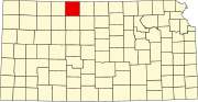 | |
| CDPs | ||
| Unincorporated community | ||
| Ghost towns | ||
| Townships |
| |
This article about a location in Phillips County, Kansas is a stub. You can help Wikipedia by expanding it. |