Tupadły, Pomeranian Voivodeship
Jump to navigation
Jump to search
Tupadły | |
|---|---|
Village | |
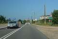
 Pucka Street in Tupadły | |
 Tupadły | |
| Coordinates: 54°49′15″N 18°18′53″E / 54.82083°N 18.31472°E | |
| Country | |
| Voivodeship | Pomeranian |
| County | Puck |
| Gmina | Władysławowo |
| Population | 439 |
| Time zone | UTC+1 (CET) |
| • Summer (DST) | UTC+2 (CEST) |
| Vehicle registration | GPU |
Tupadły is a village in the administrative district of Gmina Władysławowo, within Puck County, Pomeranian Voivodeship, in northern Poland. It lies approximately 7 km (4 mi) north-west of Władysławowo, 14 km (9 mi) north-west of Puck, and 55 km (34 mi) north-west of the regional capital Gdańsk. It is located within the historic region of Pomerania. Prior to January 1, 2015, it was a part of the town Władysławowo.[1]
Tupadły was a royal village of the Polish Crown, administratively located in the Puck County in the Pomeranian Voivodeship.[2]
Gallery
[edit]-
 Pucka Street

References
[edit]- ^ Rozporządzenie Rady Ministrów z dnia 29 lipca 2014 r. w sprawie połączenia gmin, ustalenia granic niektórych gmin i miast, nadania niektórym miejscowościom statusu miasta oraz zmiany siedziby władz gminy, Dz. U., 2014, No. 1023 (2014-07-29)
- ^ Biskup, Marian; Tomczak, Andrzej (1955). Mapy województwa pomorskiego w drugiej połowie XVI w. (in Polish). Toruń. p. 101.
{{cite book}}: CS1 maint: location missing publisher (link)
| Seat | ||
|---|---|---|
| Other villages | ||
This Puck County location article is a stub. You can help Wikipedia by expanding it. |