Third Avenue and North High Historic District
Jump to navigation
Jump to search
Third Avenue and North High Historic District | |
 | |
 Interactive map | |
| Location | N. High St. in the vicinity of 2nd and 3rd, Columbus, Ohio |
|---|---|
| Coordinates | 39°58′59″N 83°00′17″W / 39.983056°N 83.004722°W |
| Architectural style | Late 19th and early 20th century American movements |
| MPS | Short North MPS |
| NRHP reference No. | 90000585[1] |
| Added to NRHP | April 19, 1990 |
The Third Avenue and North High Historic District is a historic district in the Short North neighborhood of Columbus, Ohio. It was listed on the National Register of Historic Places in 1990.[1] The site consists of 24 buildings, including six that are non-contributing. Most are commercial or multifamily residential brick buildings built between 1900 and 1920.[2]
Gallery
[edit]-
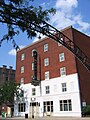 1024 N. High
 -
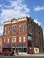 1040 N. High
 -
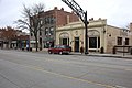 1100 and 1108 N. High


See also
[edit]References
[edit]- ^ a b "National Register Information System". National Register of Historic Places. National Park Service. March 13, 2009.
- ^ "National Register of Historic Places Registration Form". National Park Service. Retrieved December 20, 2020.

This Columbus, Ohio-related article is a stub. You can help Wikipedia by expanding it. |