Sumba
Native name: Humba / Hubba (in Sumba) | |
|---|---|
 | |
 | |
| Geography | |
| Location | Indonesia |
| Coordinates | 9°40′S 120°00′E / 9.667°S 120.000°E |
| Archipelago | Lesser Sunda Islands |
| Area | 11,243.78 km2 (4,341.25 sq mi) |
| Area rank | 73rd |
| Highest elevation | 1,225 m (4019 ft) |
| Highest point | Mount Wanggameti |
| Administration | |
Indonesia | |
| Province | East Nusa Tenggara |
| Largest settlement | Waingapu (pop. 71,752[1] - comprising Kota Waingapu and Kambera Districts) |
| Demographics | |
| Demonym | Sumbans; Sumbanese |
| Population | 820,506 (mid 2023 estimate[1]) |
| Pop. density | 72.97/km2 (188.99/sq mi) |
| Languages | Predominantly native Sumba languages (Kambera, Momboru, Anakalang, Wanukaka, Wejewa, Lamboya, Kodi, Loli) and Indonesian (national language of Indonesia) |
| Ethnic groups | Predominantly Sumbans |
Sumba (Petjo: Soemba-eiland; Indonesian: pulau Sumba), natively also spelt as Humba, Hubba, Suba, or Zuba (in Sumba languages) is an Indonesian island (part of the Lesser Sunda Archipelago group) located in the Eastern Indonesia and administratively part of the East Nusa Tenggara provincial territory. Sumba has an area of 11,243.78 square kilometres (4,341.25 square miles), about the same size as Jamaica or Hawaii (Island). The population was 686,113 at the 2010 Census[2] and 779,049 at the 2020 Census;[3] the official estimate as of mid-2023 was 820,506 (comprising 420,291 males and 400,215 females).[1] To the northwest of Sumba is Sumbawa, to the northeast, across the Sumba Strait (Selat Sumba), is Flores, to the east, across the Savu Sea, is Timor, and to the south, across part of the Indian Ocean, is Australia.
Nomenclature
[edit]
The name of this island is etymology of
the name "Sumba" is derived from the native Sumbanese word humba or hubba (in various Subanese dialects), which means “original”, “native”, “indigenous” or “no interference”; this was initially an ethnonym referring to the native inhabitants of this island who identified themselves as tau Humba or tau Hubba (lit. 'native people' or 'original people'), to differentiate themselves from foreigners (non-Sumbanese people) who gradually and continuously came to occupy the island.
_from_Melolo_village,_Indonesia,_Honolulu_Museum_of_Art_accession_12983.1.JPG?lang=en)
On the other hand, the Sumbanese cultural territory (including Sumba Island and its surrounding seas) are also known as tana wai humba or tana wae hubba (in Sumbanese languages), which means “our native land” or “the motherland of Sumba people”; these sentences appeared in ancient Sumbanese manuscripts that told the tale of Inya Nyale (a mermaid-like creature who used to live on land but then moved to the ocean), considered as a sacred figure in Sumbanese mythology.
The letter 'h' in later time (around 12th century) replaced by 's' due to the mass migration of Javanese people from the island of Java, because the word humba sounds so similar to the Javanese word of ꦲꦸꦩ꧀ꦧꦃ (umbah, but written as humbah according to Javanese writing system), meaning "to wash" or "to cleanse".
History
[edit]Oral traditions
[edit]According to Sumbanese historians, Sumba Island was once connected to the neighbouring islands to the north, namely Flores and Sumbawa.
Flores and Sumba were connected by the Kataka Lindiwatu (in Sumba languages), an ancient stone bridge built by the native of Sumba and Flores.[4] Due to the high level of socialization around the Kataka Lindiwatu which connected both islands, civilization was thought to arise from around those regions (which nowadays correspond to northern Sumba and to part of East Sumba regency territory). This story belongs to the Sumba oral traditions as was written down by Umbu Pura Woha (2007) in his book Sejarah, Musyawarah dan Adat Istiadat Sumba Timur (lit. 'History, Deliberation and Customs of East Sumba').[4]
Ancient civilization ruins
[edit]
The ruins of the historical civilization of the Sumba people dates back to the BC era; megalithic burials were found on the central regions of the island (Central Sumba) which go back to thousands of years ago. These stone-based burial traditions are still kept alive by the Sumba people and have become a 'living ancient tradition' that still can be observed by scholars in modern days.[5] The megalithic remains found on Sumba Island include dolmen tombs, upright stones, megalithic statues, stone enclosures, and levelled terraces. The Sumba megalithic tradition itself was characterized by the old megaliths built and carved with high quality standards.[6] Some ancient tools are also found on the island. Notable findings are quadrangular adzes unearthed in the Anakalang area (a cultural region of Anakalang Sumba, a subethnic group of Sumba people).[7]
One significant archaeological discovery was that of the urn burial site in Melolo[8] in the 1920s,[9] dated around 2,870 BCE.[10]
Javanese power
[edit]Around the 12th century, the kingdom of Singhasari in eastern Java gained more power over the maritime Southeast Asian territory after the kingdom defeated the Mongols; since then, this kingdom evolved into the empire known as Majapahit. Sumba Island was a subject of Majapahit's dominion, and the word "Sumba" itself was first officially used during the Majapahit era (mentioned in the ancient Javanese manuscripts of Pararaton and Sumpah Palapa oath of Gajah Mada); the word itself was thought as the closest substitution in Javanese for the native name of the island according to native Sumba people, which is Humba or Hubba. The Javanese people was predicted to arrived on the Sumba Island via the Madura and Kangean route, it was examined through the analysis on the DNA of chicken species on Sumba that are naturally only endemic to the eastern regions of Java and its neighbouring islands (which in these case, most probably Kangean Island).[11]
European colonizations
[edit]In 1522, the native Sumba came into contact with the Europeans (Portuguese) who arrived on the island by ships to exploit the natural resources of the island. Later, it also attracted the Dutch VOC to come in the region in circa 1600s era. Historically, sandalwood was the main commodity exported to Europe from this island, thus the Sumba Island back then colloquially also known as the Sandalwood Island[12] or Sandel Island (in English).
_in_Watuhadang_TMnr_20018328.jpg?lang=en)
As the time goes by, in 1866, the island of Sumba was later transferred to and dominated by the following Dutch East Indies colonization power. The well-known Christianization of the natives of Sumba Island was started in 1886 by the Dutch under the Douwe Wielenga Jesuits missionary program in the district of Laura in West Sumba.[13]
Geography, climate and ecology
[edit]
The largest town on the island is the main port of Waingapu near the mouth of the Kambaniru River, with a population of 71,752[1] (including the adjoining district of Kambera) in mid 2023.
The landscape is low, limestone hills, rather than the steep volcanoes of many Indonesian islands. There is a dry season from May to November and a rainy season from December to April. The western side of the island is more fertile and more heavily populated than the east.
Although generally thought to be originally part of the Gondwana southern hemisphere supercontinent, recent research suggests that the island might have detached from the South East Asia margin. Most of it was originally covered in deciduous monsoon forest while the south-facing slopes, which remain moist during the dry season, were evergreen rainforest.[14] The northern part of the island is extremely arid; the soils have been depleted from deforestation and erosion.[15] Sumba is in the Wallacea region, having a mixture of plants and animals of Asian and Australasian origin. Due to its distinctive flora and fauna, Sumba has been categorised by the World Wildlife Fund as the Sumba deciduous forests ecoregion. [14]
Fauna
[edit]
There are a number of mammals, but the island is particularly rich in bird-life with nearly 200 birds, of which seven endemic species and a number of others are found only here and on some nearby islands. The endemic birds include the endangered Sumba eclectus parrot, four vulnerable species — the secretive Sumba boobook owl, Sumba buttonquail, red-naped fruit-dove, and Sumba hornbill — as well as three more common species: the Sumba green pigeon, Sumba flycatcher, and apricot-breasted sunbird.[14] Saltwater crocodiles can still be found in some areas.
The Sumba hornbill or Julang Sumba (Rhyticeros everetti) is under increasing threat of extinction. Indiscriminate deforestation is threatening their survival. The population is estimated at less than 4,000 with an average density of six individuals per square kilometre. A hornbill can fly to and from over an area of up to 100 square kilometres.[16]
Threats and preservation
[edit]Most of the original forest has been cleared for the planting of maize, cassava, and other crops so only small isolated patches remain. Furthermore, this clearance is ongoing due to the growing population of the island and this represents a threat to the birds.[17]
In 1998 two national parks were designated on the island for the protection of endangered species: the Laiwangi Wanggameti National Park and Manupeu Tanah Daru National Park.
Administration
[edit]Sumba is part of the East Nusa Tenggara Province, and there is no single administrative body at the island level. The island and the very small offshore islands administered with it are split into four regencies (local government regions), following re-organisation on 2 January 2007 when two new regencies were created from parts of West Sumba Regency. The four regencies are Sumba Barat (West Sumba), Sumba Barat Daya (Southwest Sumba), Sumba Tengah (Central Sumba) and Sumba Timur (East Sumba), which together accounted for 14.7% of the provincial population in 2023. The regencies are listed below with their areas and their populations at the 2010 Census[2] and the 2020 Census,[3] together with the official estimates as at mid 2023.[1] The provincial capital is not on Sumba Island, but in Kupang on West Timor.
| Kode Wilayah |
Name of City or Regency |
Statute (including year when established) |
Area in km2 |
Pop'n 2010 Census |
Pop'n 2020 Census |
Pop'n mid 2023 Estimate |
Capital | HDI[18] 2022 estimate |
|---|---|---|---|---|---|---|---|---|
| 53.11 | East Sumba Regency (Sumba Timur) |
UU 69/1958 | 7,000.50 | 227,732 | 244,820 | 255,498 | Waingapu | 0.6617 (Medium) |
| 53.12 | West Sumba Regency (Sumba Barat) |
UU 69/1958 | 737.42 | 110,993 | 145,097 | 152,414 | Waikabubak | 0.6443 (Medium) |
| 53.17 | Central Sumba Regency (Sumba Tengah) |
UU 3/2007 | 2,060.54 | 62,485 | 85,482 | 90,521 | Waibakul | 0.6271 (Medium) |
| 53.18 | Southwest Sumba Regency (Sumba Barat Daya) |
UU 16/2007 | 1,445.32 | 284,903 | 303,650 | 322,073 | Tambolaka | 0.6315 (Medium) |
| Sumba | 11,243.78 | 686,113 | 779,049 | 820,506 |
Culture
[edit]

The west part of Sumba is inhabited by segmentary societies made of clans and of politically autonomous villages, while Sumba North and East are occupied by stratified societies[19] (based on castes[20]) made of clan confederations and led by a dominant clan from which a “king” (raja) is chosen, who yields a real political power.[19]
Thus West Sumba is more ethnically and linguistically diverse.[21] Both systems exist simultaneously with a 3-tier class system (aristocracy, common people and slaves) assimilated in such a way that - paradoxically - it does not impair the egalitarian functionning of the Western segmentary societies.[19]
Villages almost always include members of several clans, because at each generation many of the youngest ones settle in villages other than the one they originated from - which may belong to an allied clan and not their own original clan and lineage.[22]
As of 2021, Sumba is the last place on Earth where societies have remained close to the traditions of South-East Asian hill tribes and still build megalithic monuments such as dolmens for collective burials:[23] more 100 megalithic tombs are still built each year on the island. But this too reflects the East / West difference: the Western segmentary societies built many more dolmens than the Eastern stratified societies; and dolmens in the east are larger, more richly ornated and are reserved to the royal clan.[24] Waingapu, a Kodi[a] village in the west of Sumba, has some 1,400 dolmens - one of the highest concentrations on the island.[24]
The Sumbanese have a mixture of Austronesian and Melanesian ancestry.[citation needed] Sumba is home to 24 ethnic groups who speak nine Austronesian languages, some of these including several dialects.[25] The largest language group is the Kambera language, spoken by a quarter of a million people in the eastern half of Sumba.[citation needed]
Twenty-five to thirty percent of the population practices the animist Marapu religion. The remainder are Christian, a majority being Dutch Calvinist with a substantial minority being Roman Catholic. A small number of Sunni Muslims can be found along the coastal areas.[citation needed] The younger generations seem to reject Marapu. This may be at least in part because the only functioning schools are Catholic and embracing that religion is required to attend school. Whatever the cause, the difference is significant compared to some other traditional places such as Waerebo, where the locals have a Christian first name and a traditional second name.[26]
Sumba is famous for ikat textiles, particularly very detailed hand-woven ikat. The process of dyeing and weaving ikat is labor-intensive and one piece can take months to prepare.[27]
Development and living standards
[edit]Sumba is one of the poorer islands of Indonesia.
Health
[edit]A relatively high percentage of the population suffers from malaria, although the illness is almost eradicated in the western part of the island. Infant mortality is high.
Water
[edit]Access to water is one of the major challenges in Sumba. During the dry season, many streams dry out and villagers depend on wells for scarce supplies of water.[28] Villagers have to travel several kilometres several times a day to fetch water. It is mainly the women and children who are sent for water, while the men are at work. The Sumba Foundation has been active in raising sponsorship to drill wells in villages and attempting to reduce poverty on the island. As of February 2013, the Sumba Foundation was responsible for 48 wells and 191 water stations, a supplying 15 schools with water and sanitation, and reducing malaria rates by some 85%.[29]
Electricity
[edit]Electricity mainly comes from diesel generators.[30] New projects include 3 MW Bayu wind power plant (PLTB) in Kadumbul, East Sumba by PT Hywind. Another is the Bodo Hula Biomass Power Plant (PLTBm), West Sumba. 1 MW capacity. Other existing renewable electricity projects involve solar PV and micro-hydroelectricity.[31]
Tourism
[edit]
Areas of interest
[edit]- Tanggedu Waterfall, 26 kilometres north-west of Waingapu (the East Sumba Regency's capital city).[32]
- Puru Kambera Beach, 26 kilometres from Waingapu, a one-hour drive
- Tarimbang Bay, 120 kilometres from Waingapu, a three-hour drive, is a surfers paradise with 2- to 3-meter tall waves between June and September.
- Watu Mandorak Cove, a white sandy beach with cliffs, a two-hour drive, and 42 kilometers from Tambolaka in the dry season. It takes longer and is not recommended in the rainy season.[33]
- The Sumba Hospitality Foundation is located in Sumba Barat or West Sumba. The Foundation is an organization dedicated to providing vocational education in hospitality to underprivileged students hailing from all across Sumba.[34]
Resorts
[edit]NIHI Sumba has been ranked as one of the world's five best eco-hotels and was awarded the world's best hotel of 2016 and 2017 from Travel + Leisure for its native ambiance and authentic local experience.[35]
See also
[edit]Notes
[edit]References
[edit]- ^ a b c d e Badan Pusat Statistik, Jakarta, 28 February 2024, Provinsi Nusa Tenggara Timur Dalam Angka 2024 (Katalog-BPS 1102001.53)
- ^ a b Biro Pusat Statistik, Jakarta, 2011.
- ^ a b Badan Pusat Statistik, Jakarta, 2021.
- ^ a b "Kampung Wunga, Tanah Kelahiran Masyarakat Sumba" [Wunga Settlement, The Birthplace of Sumba Community] (in Indonesian). 2014.
- ^ Richter, Anne; Carpenter, Bruce W.; Carpenter, Bruce; Sundermann, Jorg (16 May 2012). Gold Jewellery of the Indonesian Archipelago. Editions Didier Millet. p. 119. ISBN 978-981-4260-38-1. Retrieved 2 February 2013.
- ^ "Kampung Tarung Sumba" [Tarung Settlement of Sumba] (in Indonesian). 2018.
- ^ Simanjuntak, Truman (2006). Archaeology: Indonesian Perspective : R.P. Soejono's Festschrift. Yayasan Obor Indonesia. p. 288. ISBN 978-979-26-2499-1. Retrieved 2 February 2013.
- ^ "Melolo, map". google.com/maps.
- ^ Handini, Retno; Noerwidi, Sofwan; Sofian, Harry Octavianus; Fauzi, Ruly; Prasetyo, Unggul; Geria, I Made; Ririmasse, Marlon; Nasution, Devi Ayu Aurora; Rahayuni, Restu Ambar; Simanjuntak, Truman (July–August 2023). "New evidence on the early human occupation in Sumba Islands" [Nouvelles preuves de l’occupation humaine précoce dans les îles de Sumba]. L'Anthropologie. 127 (3). Retrieved 2024-06-15.
- ^ Koesbardiati, Toetik; Murti, Delta Bayu; Herina, Dessytri Ayu; Sari, Ayu Ambar (2018). "The occurrence of enamel hypoplasia, porotic hyperostosis and cribra orbitalia in three prehistoric skeletal assemblages from Indonesia". Bull Int Assoc Paleodont. 12 (2): 33–40. Retrieved 2024-06-15.
- ^ "Antara Majapahit, Sumba, dan Ayam Jantan Merah" [(Connecting the Dots) Between Majapahit, Sumba, and the Red Rooster]. Indonesian Institute of Sciences (in Indonesian). 2016.
- ^ Goodall, George (editor) (1943) Philips' International Atlas, London, George Philip and Son map 'East Indies' pp.91-92
- ^ Barker, Joshua (1 July 2009). State of Authority: The State in Society in Indonesia. SEAP Publications. p. 123. ISBN 978-0-87727-780-4. Retrieved 2 February 2013.
- ^ a b c Wikramanayake, Eric D. (2002). Terrestrial Ecoregions of the Indo-Pacific: A Conservation Assessment. Island Press. p. 532. ISBN 978-1-55963-923-1. Retrieved 2 February 2013.
- ^ "Sumba". sumba-information.eu (in French). Retrieved 2024-06-15.
- ^ "Sumba Hornbills under increasing threat of extinction". Antara News. Retrieved 2 February 2013.
- ^ "Sumba deciduous forests". Terrestrial Ecoregions. World Wildlife Fund.
- ^ "[New Method] Human Development Index by Regency/City 2020-2022" (in Indonesian). Statistics Indonesia. 2022. Retrieved 13 February 2023.
- ^ a b c Jeunesse, Christian; Bec-Drelon, Noisette; Boulestin, Bruno; Denaire, Anthony (2021). "Aspects de la gestion des dolmens et des tombes collectives actuels dans les sociétés de l'île de Sumba (Indonésie)" [Ethnoarchaeology of funeral practices: aspects of the management of current dolmens and collective tombs in the tribal societies of Sumba Island (Indonesia)]. Préhistoires méditerranéennes. 9 (2): 165-179 (see § 6). Retrieved 2024-06-15.
- ^ Forshee, Jill (2006). Culture and Customs of Indonesia. Greenwood Publishing Group. p. 41. ISBN 978-0-313-33339-2. Retrieved 2 February 2013.
- ^ Müller, Kal (1997). East of Bali: From Lombok to Timor. Tuttle Publishing. p. 170. ISBN 978-962-593-178-4. Retrieved 2 February 2013.
- ^ Jeunesse et al. 2021, § 7.
- ^ Jeunesse et al. 2021, § 3.
- ^ a b Jeunesse et al. 2021, § 8.
- ^ a b Jeunesse et al. 2021, § 4.
- ^ "Marapu and other weird things in Sumba". whatsnextnaomi.com. Retrieved 2024-06-15.
- ^ Sertori, Trisha (30 August 2012). "Sumba on show in Bali". The Jakarta Post. Retrieved 2024-06-15.
- ^ Hoepfner, Maren (4 March 2010). "Taking Sumba by surprise". The Jakarta Post. Retrieved 2024-06-15.
- ^ "The Sumba Foundation". sumbafoundation.org. Retrieved 2024-06-15.
- ^ Oswal, R.; Jain, P.; Muljadi, E.; Hirsch, B.; Castermans, B.; Chandra, J.; Raharjo; Hardison, R. (January 2016). "System Impact Study of the Eastern Grid of Sumba Island, Indonesia. Steady-State and Dynamic System Modeling for the Integration of One and Two 850-kW Wind Turbine Generators" (PDF) (Technical Report NREL/TP-5D00-65458). US National Renewable Energy Laboratory (NREL). p. 1.
- ^ "100% Renewable energy Atlas: Sumba Island, Indonesia". 100-percent.org. Retrieved 21 April 2020.
- ^ Annabel Symonds (9 March 2017). "7 Tips For Visiting Tanggedu Waterfall In Sumba Indonesia". londonerinsydney.com. Retrieved 2024-06-15.
- ^ "Sumba". komodotouristic.com. Retrieved 2024-06-15.
- ^ "Sumba Hospitality Foundation". sumbahospitalityfoundation.org. Retrieved 2024-06-15.
- ^ Intan Tanjung (July 12, 2016). "Indonesia home to 'world's best hotel' of 2016". thejakartapost.com. Retrieved 2024-06-15.
Bibliography
[edit]- Paccou-Martellière, Véronique; Hinterseer, Thomas H. (2016). Arts and traditions of Sumba. Paris: Le Livre D Art. ISBN 978-2-355-32241-9.
External links
[edit]- Sumba tourist and social information (private website)
- . Encyclopædia Britannica (11th ed.). 1911.
Maps
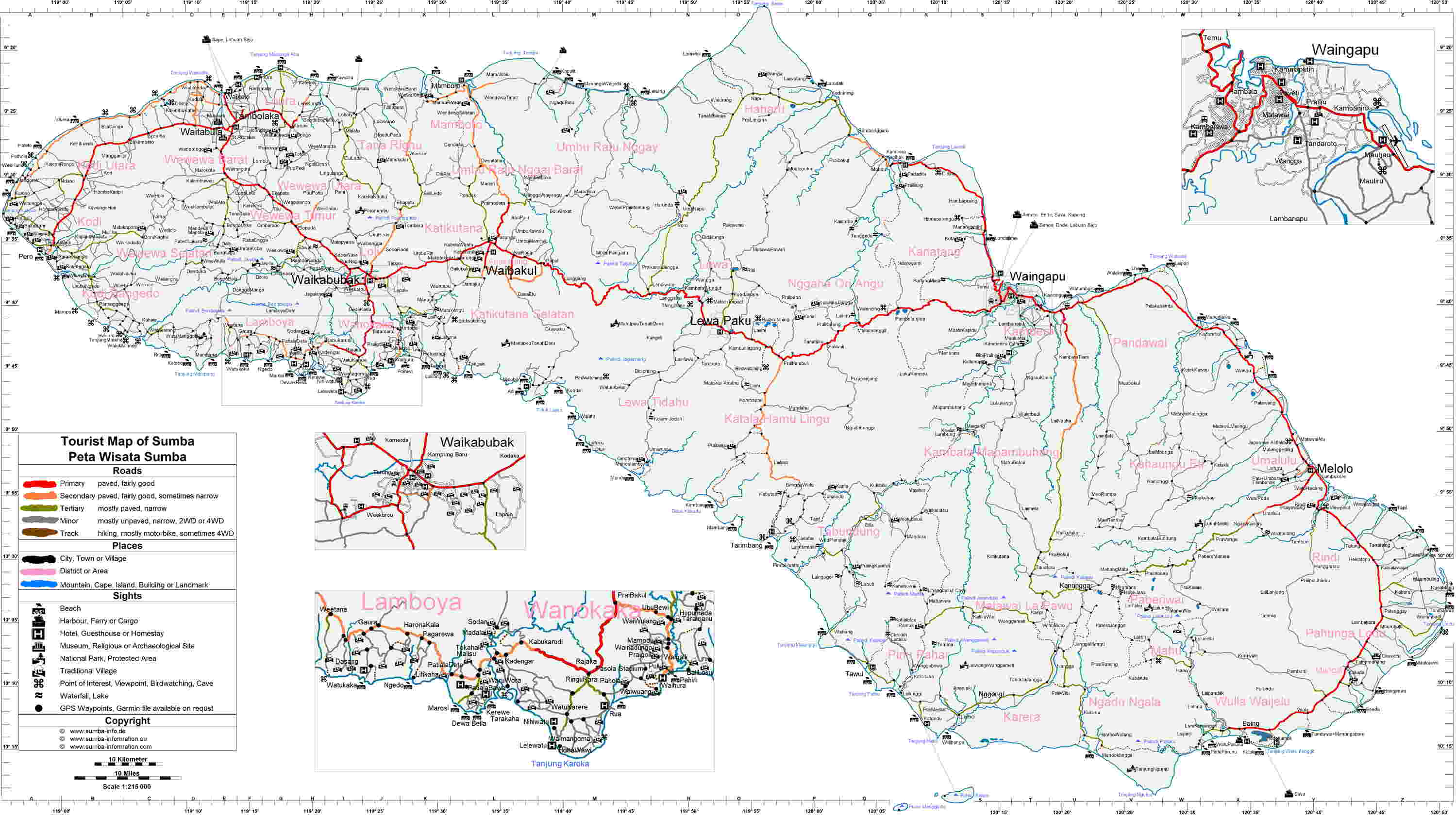
[edit]- "Tourist and Road Map of Sumba". files.creatr.de. Retrieved 2024-06-15.
- "High-resolution map of West Sumba with contour lines". maps.lib.utexas.edu (made by the US Army Map service). Retrieved 2024-06-15.
| International | |
|---|---|
| National | |