Schwartzenbach Falls
| Schwartzenbach Falls | |
|---|---|
| Qulitasaniakvik | |
 Weasel River Valley with Schwartzenbach Falls in the distance | |
 | |
| Location | Auyuittuq National Park, Nunavut, Canada |
| Coordinates | 66°30′30″N 65°31′30″W / 66.5083°N 65.5250°W |
| Type | Tiered Horsetails |
| Elevation | 640 m (2,100 ft)[1] |
| Total height | 520 m (1,710 ft)[1] |
| Number of drops | 5 |
| Longest drop | 200 m (660 ft)[1] |
| Total width | 30 m (98 ft)[1] |
| Average width | 30 m (98 ft) |
| Run | 884 m (2,900 ft)[1] |
| Watercourse | Unnamed stream |
| Average flow rate | 3 m3/s (110 cu ft/s)[1] |
| World height ranking | 111th[2] |
Schwartzenbach Falls, also known as Qulitasaniakvik, is a tiered horsetail waterfall located in the Weasel River Valley of Baffin Island in Nunavut, Canada. With an overall height of 520 m (1,710 ft), it is the 4th tallest waterfall in Canada and the tallest in Canada outside of British Columbia.[1]
Name origin
[edit]The Inuktitut name for the waterfall is Qulitasaniakvik, which means "place to get caribou skins". The name refers to the valley above the falls being a good place to hunt for caribou.[1][3]
Structure
[edit]The falls form from an unnamed stream that plummets 520 m (1,710 ft) down the western wall of the Weasel River Valley. The initial drop leaps 200 m (660 ft) over the edge of an inclined cliff and takes the form of a horsetail. This is followed by a series of four smaller cascades that descend an additional 320 m (1,050 ft) before the cliff gives way to a collection of talus deposits.[1]
See also
[edit]References
[edit]- ^ a b c d e f g h i "Schwartzenbach Falls, Nunavut, Canada - World Waterfall Database". www.worldwaterfalldatabase.com. Retrieved 2020-11-04.
- ^ "Tallest and Largest Waterfalls at the World Waterfall Database". www.worldwaterfalldatabase.com. Retrieved 2020-11-05.
- ^ "Auyuittuq National Park". bivouac.ca. Retrieved 2020-11-04.
External links
[edit]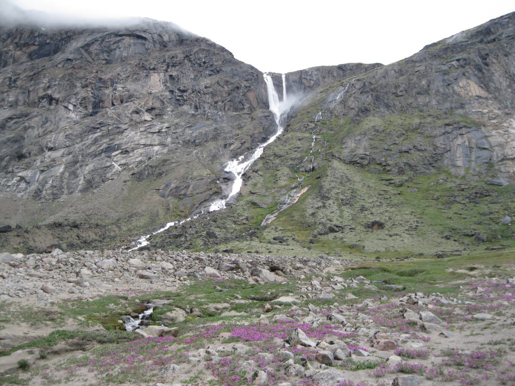
| Authority control databases: Geographic |
|---|