The Blue Marble, a photograph of the planet Earth made on 7 December 1972 by the crew of the Apollo 17 spacecraft.
The world is the totality of entities, the whole of reality, or everything that exists. The nature of the world has been conceptualized differently in different fields. Some conceptions see the world as unique while others talk of a "plurality of worlds". Some treat the world as one simple object while others analyze the world as a complex made up of parts.
In scientific cosmology, the world or universe is commonly defined as "[t]he totality of all space and time; all that is, has been, and will be". Theories of modality talk of possible worlds as complete and consistent ways how things could have been. Phenomenology, starting from the horizon of co-given objects present in the periphery of every experience, defines the world as the biggest horizon or the "horizon of all horizons". In philosophy of mind, the world is contrasted with the mind as that which is represented by the mind. Theology conceptualizes the world in relation to God, for example, as God's creation, as identical to God or as the two being interdependent. In religions, there is a tendency to downgrade the material or sensory world in favor of a spiritual world to be sought through religious practice. A comprehensive representation of the world and our place in it, as is found in religions, is known as a worldview. Cosmogony is the field that studies the origin or creation of the world while eschatology refers to the science or doctrine of the last things or of the end of the world.
Sustainability is a social goal for people to co-exist on Earth over a long time. Definitions of this term are disputed and have varied with literature, context, and time. Sustainability usually has three dimensions (or pillars): environmental, economic, and social. Many definitions emphasize the environmental dimension. This can include addressing key environmental problems, including climate change and biodiversity loss. The idea of sustainability can guide decisions at the global, national, and individual levels. A related concept is that of sustainable development, and the terms are often used to mean the same thing. UNESCO distinguishes the two like this: "Sustainability is often thought of as a long-term goal (i.e. a more sustainable world), while sustainable development refers to the many processes and pathways to achieve it."
Details around the economic dimension of sustainability are controversial. Scholars have discussed this under the concept of weak and strong sustainability. For example, there will always be tension between the ideas of "welfare and prosperity for all" and environmental conservation, so trade-offs are necessary. It would be desirable to find ways that separate economic growth from harming the environment. This means using fewer resources per unit of output even while growing the economy. This reduces the environmental impact of economic growth, such as pollution. Doing this is difficult. Some experts say there is no evidence that it is happening at the required scale. (Full article...)
The UNGA is responsible for the UN budget, appointing the non-permanent members to the Security Council, appointing the UN secretary-general, receiving reports from other parts of the UN system, and making recommendations through resolutions. It also establishes numerous to advance or assist in its broad mandate. The UNGA is the only UN organ where all member states have equal representation. (Full article...)
Image 3
The astronomical symbol of Earth represents either the four quadrants of the world or the four continents.
This period is characterized by changes in emphasis on particular areas of space exploration and applications. Initially, the United States and the Soviet Union invested unprecedented amounts of resources in breaking records and being first to meet milestones in crewed and uncrewed exploration. The United States established the National Aeronautics and Space Administration (NASA) and the USSR established the Kosmicheskaya programma SSSR to meet these goals. This period of competition gave way to cooperation between those nations and emphasis on scientific research and commercial applications of space-based technology. (Full article...)
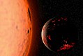
Artist's rendition of a fully-frozen Snowball Earth with no remaining liquid surface water.The Snowball Earth is a geohistorical hypothesis that proposes during one or more of Earth's icehouse climates, the planet's surface became nearly entirely frozen with no liquid oceanic or surface water exposed to the atmosphere. The most academically referred period of such global glaciation is believed to have occurred sometime before 650 mya during the Cryogenian period.
Proponents of the hypothesis argue that it best explains sedimentary deposits that are generally believed to be of glacial origin at tropical palaeolatitudes and other enigmatic features in the geological record. Opponents of the hypothesis contest the geological evidence for global glaciation and the geophysical feasibility of an ice- or slush-covered ocean, and they emphasize the difficulty of escaping an all-frozen condition. Several unanswered questions remain, including whether Earth was a full snowball or a "slushball" with a thin equatorial band of open (or seasonally open) water. The snowball-Earth episodes are proposed to have occurred before the sudden radiation of multicellular bioforms known as the Cambrian explosion. The most recent snowball episode may have triggered the evolution of multicellularity. (Full article...)
The Central Bureau of the Map of the World was established in London. After the Second World War, UNESCO took over the project. By 1953, 400 sheets had been produced. The completed sheets became outdated before the project had produced a full set of maps, and by the 1960s was being dismissed as being of no practical use. The project was no longer monitored by the 1990s. (Full article...)
Image 2Earth's night-side upper atmosphere appearing from the bottom as bands of afterglow illuminating the troposphere in orange with silhouettes of clouds, and the stratosphere in white and blue. Next the mesosphere (pink area) extends to the orange and faintly green line of the lowest airglow, at about one hundred kilometers at the edge of space and the lower edge of the thermosphere (invisible). Continuing with green and red bands of aurorae stretching over several hundred kilometers. (from Earth)
Image 3Earth's land use for human agriculture in 2019 (from Earth)
Image 5The replicator in virtually all known life is deoxyribonucleic acid. DNA is far more complex than the original replicator and its replication systems are highly elaborate. (from History of Earth)
Image 8Artist's impression of Earth during the later Archean, the largely cooled planetary crust and water-rich barren surface, marked by volcanoes and continents, features already roundmicrobialites. The Moon, still orbiting Earth much closer than today and still dominating Earth's sky, produced strong tides. (from History of Earth)
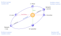
Image 13Exaggerated illustration of Earth's elliptical orbit around the Sun, marking that the orbital extreme points (apoapsis and periapsis) are not the same as the four seasonal extreme points, the equinox and solstice (from Earth)
Image 14Conjectured illustration of the scorched Earth after the Sun has entered the red giant phase, about 5–7 billion years from now (from Earth)
Image 18An animation of the changing density of productive vegetation on land (low in brown; heavy in dark green) and phytoplankton at the ocean surface (low in purple; high in yellow) (from Earth)
Image 19A schematic view of Earth's magnetosphere with solar wind flowing from left to right (from Earth)
Image 22Trilobites first appeared during the Cambrian period and were among the most widespread and diverse groups of Paleozoic organisms. (from History of Earth)
Image 31Pillar erected by India's Maurya Emperor Ashoka
Image 32Tiktaalik, a fish with limb-like fins and a predecessor of tetrapods. Reconstruction from fossils about 375 million years old. (from History of Earth)
Image 45Change in average surface air temperature and drivers for that change. Human activity has caused increased temperatures, with natural forces adding some variability. (from Earth)
Image 49Artist's impression of a Hadean landscape with the relatively newly formed Moon still looming closely over Earth and both bodies sustaining strong volcanism. (from History of Earth)
Image 62Pangaea was a supercontinent that existed from about 300 to 180 Ma. The outlines of the modern continents and other landmasses are indicated on this map. (from History of Earth)
Image 68A view of Earth with its global ocean and cloud cover, which dominate Earth's surface and hydrosphere; at Earth's polar regions, its hydrosphere forms larger areas of ice cover. (from Earth)
Image 72An artist's impression of the Archean, the eon after Earth's formation, featuring round stromatolites, which are early oxygen-producing forms of life from billions of years ago. After the Late Heavy Bombardment, Earth's crust had cooled, its water-rich barren surface is marked by continents and volcanoes, with the Moon still orbiting Earth half as far as it is today, appearing 2.8 times larger and producing strong tides. (from Earth)
Image 74Earth's western hemisphere showing topography relative to Earth's center instead of to mean sea level, as in common topographic maps (from Earth)
Image 75Earth's axial tilt causing different angles of seasonal illumination at different orbital positions around the Sun (from Earth)
Image 78A reconstruction of human history based on fossil data. (from History of Earth)
Image 79A 2012 artistic impression of the early Solar System's protoplanetary disk from which Earth and other Solar System bodies were formed (from Earth)
Image 86Geologic map of North America, color-coded by age. From most recent to oldest, age is indicated by yellow, green, blue, and red. The reds and pinks indicate rock from the Archean.
Xiamen Island possessed a major international seaport. The port of Xiamen is a well-developed first-class trunk line port in the Asia-Pacific region. It is ranked the 7th-largest container port in China and ranks 13th in the world. It is the 4th port in China with the capacity to handle 6th-generation large container ships. On 31 August 2010, Xiamen Port incorporated the neighboring port of Zhangzhou to form the largest port of China's Southeast. Ever since the 12th century, Xiamen was also an important origin for many migrants to Singapore, Malaysia, Indonesia and the Philippines. The overseas Chinese used to support Xiamen's educational and cultural institutions. Xiamen is classified as a Large-Port Metropolis. (Full article...)
... that decades after the type specimen of the lichen Punctelia graminicola was destroyed in World War II, its original name was restored after another specimen was rescued from disposal at a dump?
... that during World War II, the governor of Portuguese Timor was confined to the Palácio de Lahane by the territory's Japanese occupiers?
... that a willow maze in Sussex, England, planted in the shape of a quotation from the Bible in the 1990s, only came to wider notice when it was spotted on Google Earth in 2013?
The Seven Wonders of Colombia (Spanish: Siete maravillas de Colombia) was a 2007 competition sponsored by El Tiempo. The newspaper asked readers to nominate and vote for man-made structures whose engineering, architectural or historical value deserved special recognition. (Full article...)
This is a list of protected areas of Yukon. The Yukon, formerly called Yukon Territory and sometimes referred to as just Yukon is the smallest and westernmost of Canada's three territories. It also is the least populated province or territory in Canada, with a population of 35,874 people as of the 2016 Census. (Full article...)
Meanwhile, the central government has proclaimed the Coastline and the Tirana Greenbelt as areas of national importance. (Full article...)
Image 4
Protected areas of Indonesia comprise both terrestrial and marine environments in any of the six IUCN Protected Area categories. There are over 500 protected areas in Indonesia, of which 54 National Parks cover 16.4 million ha, and another 527 nature and game reserves cover a further 28.3 million ha. The total protected land area represents over 15% of Indonesia's landmass. Marine Protected Areas comprise over 15.7 million ha representing ca. 5% of territorial waters. (Full article...)
Image 5
Upolu Island, Samoa This is a list of some protected areas of Samoa which include national parks, reservations, protected nature zones, marine reserves and other areas of significant biodiversity and conservation.
In 1994, Samoa ratified the international and legally binding treaty, the Convention on Biological Diversity to develop national strategies for conservation and sustainable use of biological diversity. In 2010, protected areas in the country cover 5% of land although the government aims to increase protected areas coverage to 15%. (Full article...)
Image 6
The mountain of Stob Binnein lies in the Loch Lomond and The Trossachs National Park. Many parts of Scotland are protected in accordance with a number of national and international designations because of their environmental, historical or cultural value. Protected areas can be divided according to the type of resource which each seeks to protect. NatureScot has various roles in the delivery of many environmental designations in Scotland, i.e. those aimed at protecting flora and fauna, scenic qualities and geological features. Historic Environment Scotland is responsible for designations that protect sites of historic and cultural importance. Some international designations, such as World Heritage Sites, can cover both categories of site.
The various designations overlap considerably with many protected areas being covered by multiple designations with different boundaries. (Full article...)
Protected areas of Ukraine (Ukrainian: охоронні території) are special areas of Ukraine established with the goal of protecting the natural and cultural heritage of the country from excessive changes as a result of human activity. The protection of the areas is the responsibility of the government of Ukraine, specifically the Cabinet of Ministers of Ukraine.
The sun over the Lake Niassa Reserve Protected areas in Mozambique are known as conservation areas, and are currently grouped into national parks, national reserves, forest reserves, wildlife utilisation areas (coutadas), community conservation areas, and private game farms (fazendas de bravio). There are also a number of areas that have been declared as protected areas under a variety of different legislation, which for reasons of simplicity are here grouped together as "other protected areas." Under the Conservation Law of 2014 (Law 16/2014 of June 20), protected areas will need to be reclassified into a much more flexible series of new categories which are closer to the international system used by the IUCN. International initiatives such as transfrontier parks are grouped at the end of the page. (Full article...)
Image 11
This is a list of the nationally designated protected areas of China. There are many forms of protected areas in China. Based on their relative importance, each type of protected area can be further graded into two to three levels (national, provincial and prefectural/county level). Nevertheless, the highest rank for "pocket nature preserve" (social and mass-based), "no-hunting area", "no-fishing area", "no-logging area", "wild medicinal material resources conservation area", "crop germplasm resources conservation area", "forest tree germplasm resources conservation area" or "source water protection area" is practically restricted to provincial level. The local government at county level is also responsible for the delimitation and declaration of "basic farmland protection area" and "basic grassland".
Take note that many protected areas in China have multiple official designations, and the statutory boundaries of these multi-designated PAs may be identical or may vary one from the other. For instance, the boundaries of Huangshan NSHA coincide with those of the Huangshan NGP, whereas Fujian province's Wuyi Mountains NNR, NSHA and NFP are adjacent to each other. In Heilongjiang, 27,642.14 hectares out of 115,340.27 hectares of Huzhong NFP are intersected with the experiment zone of Huzhong NNR. (Full article...)
Image 3Only a few of the largest large igneous provinces appear (coloured dark purple) on this geological map, which depicts crustal geologic provinces as seen in seismic refraction data


 Sustainability is a social goal for people to co-exist on Earth over a long time. Definitions of this term are disputed and have varied with literature, context, and time. Sustainability usually has three dimensions (or pillars): environmental, economic, and social. Many definitions emphasize the environmental dimension. This can include addressing key environmental problems, including climate change and biodiversity loss. The idea of sustainability can guide decisions at the global, national, and individual levels. A related concept is that of sustainable development, and the terms are often used to mean the same thing. UNESCO distinguishes the two like this: "Sustainability is often thought of as a long-term goal (i.e. a more sustainable world), while sustainable development refers to the many processes and pathways to achieve it."


 Cross-section through a liposome (from History of Earth)
 Earth's night-side upper atmosphere appearing from the bottom as bands of afterglow illuminating the troposphere in orange with silhouettes of clouds, and the stratosphere in white and blue. Next the mesosphere (pink area) extends to the orange and faintly green line of the lowest airglow, at about one hundred kilometers at the edge of space and the lower edge of the thermosphere (invisible). Continuing with green and red bands of aurorae stretching over several hundred kilometers. (from Earth)
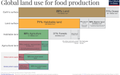 Earth's land use for human agriculture in 2019 (from Earth)
 An artist's rendering of a protoplanetary disk (from History of Earth)
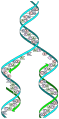 The replicator in virtually all known life is deoxyribonucleic acid. DNA is far more complex than the original replicator and its replication systems are highly elaborate. (from History of Earth)

 Artist's impression of Earth during the later Archean, the largely cooled planetary crust and water-rich barren surface, marked by volcanoes and continents, features already round microbialites. The Moon, still orbiting Earth much closer than today and still dominating Earth's sky, produced strong tides. (from History of Earth)
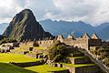 Machu Picchu, Inca Empire, Peru
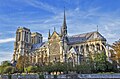 Notre-Dame de Paris, France
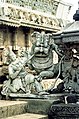 Chennakesava Temple, Belur, India
 Ajloun Castle, Jordan
 A pillar at Göbekli Tepe
 An animation of the changing density of productive vegetation on land (low in brown; heavy in dark green) and phytoplankton at the ocean surface (low in purple; high in yellow) (from Earth)
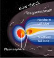 A schematic view of Earth's magnetosphere with solar wind flowing from left to right (from Earth)
 Last Moon landing: Apollo 17 (1972)
 Fall of the Berlin Wall, 1989
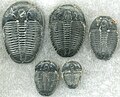 Trilobites first appeared during the Cambrian period and were among the most widespread and diverse groups of Paleozoic organisms. (from History of Earth)
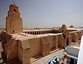 Great Mosque of Kairouan, Tunisia, founded 670 CE
 First airplane, the Wright Flyer, flew on 17 December 1903.
 Dinosaurs were the dominant terrestrial vertebrates throughout most of the Mesozoic (from History of Earth)
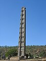 Obelisk of Axum, Ethiopia
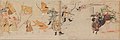
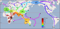 Peopling of the world, the Southern Dispersal scenario
 Tracy Caldwell Dyson, a NASA astronaut, observing Earth from the Cupola module at the International Space Station on 11 September 2010 (from Earth)
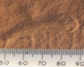 A 580 million year old fossil of Spriggina floundensi, an animal from the Ediacaran period. Such life forms could have been ancestors to the many new forms that originated in the Cambrian Explosion. (from History of Earth)
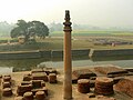
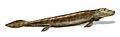 Tiktaalik, a fish with limb-like fins and a predecessor of tetrapods. Reconstruction from fossils about 375 million years old. (from History of Earth)
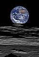 View of Earth from the Moon by the Lunar Reconnaissance Orbiter (from Earth)
 Shanghai. China urbanized rapidly in the 21st century.
 "Lucy", the first Australopithecus afarensis skeleton found, was only 1.06 m (3 ft 6 in) tall.
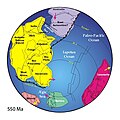 A reconstruction of Pannotia (550 Ma). (from History of Earth)
 A view of Earth with different layers of its atmosphere visible: the troposphere with its clouds casting shadows, a band of stratospheric blue sky at the horizon, and a line of green airglow of the lower thermosphere around an altitude of 100 km, at the edge of space (from Earth)
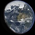 An artist's impression of ice age Earth at glacial maximum. (from History of Earth)
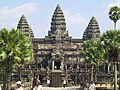 Angkor Wat temple complex, Cambodia, early 12th century
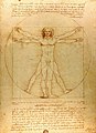 Vitruvian Man by Leonardo da Vinci epitomizes the advances in art and science seen during the Renaissance. (from History of Earth)
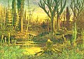 Artist's conception of Devonian flora (from History of Earth)
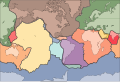
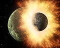 Artist's impression of the enormous collision that probably formed the Moon (from History of Earth)
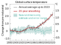 Change in average surface air temperature and drivers for that change. Human activity has caused increased temperatures, with natural forces adding some variability. (from Earth)
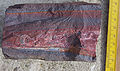 A banded iron formation from the 3.15 Ga Moodies Group, Barberton Greenstone Belt, South Africa. Red layers represent the times when oxygen was available; gray layers were formed in anoxic circumstances. (from History of Earth)
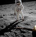
 Battle during the 1281 Mongol invasion of Japan
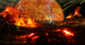 Artist's impression of a Hadean landscape with the relatively newly formed Moon still looming closely over Earth and both bodies sustaining strong volcanism. (from History of Earth)
 Empires of the world in 1898
 Pale orange dot, an artist's impression of Early Earth, featuring its tinted orange methane-rich early atmosphere (from Earth)
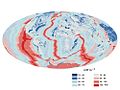 A map of heat flow from Earth's interior to the surface of Earth's crust, mostly along the oceanic ridges (from Earth)
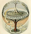 Yggdrasil, an attempt to reconstruct the Norse world tree which connects the heavens, the world, and the underworld. (from World)
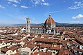 Florence, birthplace of the Italian Renaissance
 Artist's conception of Hadean Eon Earth, when it was much hotter and inhospitable to all forms of life. (from History of Earth)
 Chloroplasts in the cells of a moss (from History of Earth)
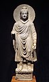 Standing Buddha from Gandhara, 2nd century CE
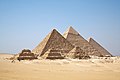 Great Pyramids of Giza, Egypt
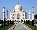 Taj Mahal, Mughal Empire, India
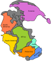 Pangaea was a supercontinent that existed from about 300 to 180 Ma. The outlines of the modern continents and other landmasses are indicated on this map. (from History of Earth)
 Ming dynasty section, Great Wall of China
 Graph showing range of estimated partial pressure of atmospheric oxygen through geologic time (from History of Earth)
 Satellite time lapse imagery of Earth's rotation showing axis tilt (from Earth)
 Image of the physical world, captured by the Hubble Space Telescope (from World)
 A composite image of Earth, with its different types of surface discernible: Earth's surface dominating Ocean (blue), Africa with lush (green) to dry (brown) land and Earth's polar ice in the form of Antarctic sea ice (grey) covering the Antarctic or Southern Ocean and the Antarctic ice sheet (white) covering Antarctica. (from Earth)
 A view of Earth with its global ocean and cloud cover, which dominate Earth's surface and hydrosphere; at Earth's polar regions, its hydrosphere forms larger areas of ice cover. (from Earth)
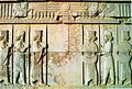 Persepolis, Achaemenid Empire, 6th century BCE
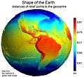 Earth's western hemisphere showing topography relative to Earth's center instead of to mean sea level, as in common topographic maps (from Earth)
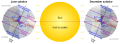 Earth's axial tilt causing different angles of seasonal illumination at different orbital positions around the Sun (from Earth)
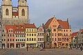
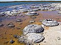 Lithified stromatolites on the shores of Lake Thetis, Western Australia. Archean stromatolites are the first direct fossil traces of life on Earth. (from History of Earth)
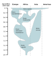 A reconstruction of human history based on fossil data. (from History of Earth)
 A 2012 artistic impression of the early Solar System's protoplanetary disk from which Earth and other Solar System bodies were formed (from Earth)
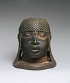 Benin Bronze head from Nigeria
 Artist's rendition of an oxinated fully-frozen Snowball Earth with no remaining liquid surface water. (from History of Earth)
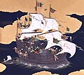 Japanese depiction of a Portuguese carrack. European maritime innovations led to proto-globalization.
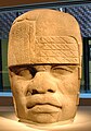 Olmec colossal head, now at the Museo de Antropología de Xalapa
 Earth's history with time-spans of the eons to scale (from History of Earth)
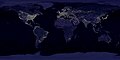 A composite image of artificial light emissions at night on a map of Earth (from Earth)
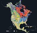 Geologic map of North America, color-coded by age. From most recent to oldest, age is indicated by yellow, green, blue, and red. The reds and pinks indicate rock from the Archean.
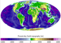
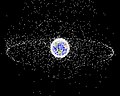 A computer-generated image mapping the prevalence of artificial satellites and space debris around Earth in geosynchronous and low Earth orbit (from Earth)


.jpg?lang=en)


.jpg?lang=en)

.svg?lang=en)


.jpeg?lang=en)


.jpg?lang=en)


.svg?lang=en)


.jpg?lang=en)


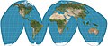 The Goode homolosine projection is a pseudocylindrical, equal-area, composite map projection used for world maps.
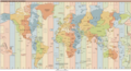 Time zones of the world
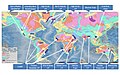 Only a few of the largest large igneous provinces appear (coloured dark purple) on this geological map, which depicts crustal geologic provinces as seen in seismic refraction data
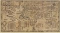 1516 map of the world by Martin Waldseemüller
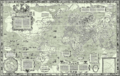 The world map by Gerardus Mercator (1569), the first map in the well-known Mercator projection
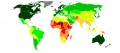 United Nations Human Development Index map by country (2016)
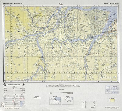
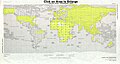 Index map from the International Map of the World (1:1,000,000 scale)
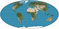 Mollweide projection of the world
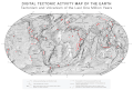 A plate tectonics map with volcano locations indicated with red circles


 Commons
 Wikibooks
 Wikidata
 Wikinews
 Wikiquote
 Wikisource
 Wikispecies
 Wikiversity
 Wikivoyage
 Wiktionary


