Portal:New York (state)
The New York State portal


New York, sometimes called New York State, is a state in the Northeastern United States. One of the Mid-Atlantic states, it borders the Atlantic Ocean, New England, Canada and the Great Lakes. With almost 19.6 million residents, it is the fourth-most populous state in the United States and eighth-most densely populated as of 2023. New York is the 27th-largest U.S. state by area, with a total area of 54,556 square miles (141,300 km2).
New York has a varied geography. The southeastern part of the state, known as Downstate, encompasses New York City, the most populous city in the United States, with over twice the population of Los Angeles, the nation's second-largest city; Long Island, the nation's most populous island; and the suburbs and wealthy enclaves of the lower Hudson Valley. These areas are the center of the New York metropolitan area, a sprawling urban landmass, and account for approximately two-thirds of the state's population. The much larger Upstate area spreads from the Great Lakes to Lake Champlain, and includes the Adirondack Mountains and the Catskill Mountains (part of the wider Appalachian Mountains). The east–west Mohawk River Valley bisects the more mountainous regions of Upstate, and flows into the north–south Hudson River valley near the state capital of Albany. Western New York, home to the cities of Buffalo and Rochester, is part of the Great Lakes region and borders Lake Ontario and Lake Erie. Central New York is anchored by the city of Syracuse; between the central and western parts of the state, New York is dominated by the Finger Lakes, a popular tourist destination. To the south, along the state border with Pennsylvania, the Southern Tier sits atop the Allegheny Plateau, representing the northernmost reaches of Appalachia.
New York was one of the original Thirteen Colonies that went on to form the United States. The area of present-day New York had been inhabited by tribes of the Algonquians and the Iroquois Confederacy Native Americans for several thousand years by the time the earliest Europeans arrived. Stemming from Henry Hudson's expedition in 1609, the Dutch established the multiethnic colony of New Netherland in 1621. England seized the colony from the Dutch in 1664, renaming it the Province of New York. During the American Revolutionary War, a group of colonists eventually succeeded in establishing independence, and the state ratified the then new United States Constitution in 1788. From the early 19th century, New York's development of its interior, beginning with the construction of the Erie Canal, gave it incomparable advantages over other regions of the United States. The state built its political, cultural, and economic ascendancy over the next century, earning it the nickname of the "Empire State." Although deindustrialization eroded a portion of the state's economy in the second half of the 20th century, New York in the 21st century continues to be considered as a global node of creativity and entrepreneurship, social tolerance, and environmental sustainability. (Full article...)
 Good article -

The Empire State is a nickname for the U.S. state of New York, adopted in the 1800s. It has been incorporated into the names of several state buildings and events.
The source of the nickname is unknown and has puzzled many historians; as American writer Paul Eldridge put it, "Who was the merry wag who crowned the State ... [as the Empire State]? New York would certainly raise a monument to his memory, but he made his grandiose gesture and vanished forever." (Full article...)Selected article -

The Catskill Mountains, also known as the Catskills, are a physiographic province and subrange of the larger Appalachian Mountains, located in southeastern New York. As a cultural and geographic region, the Catskills are generally defined as those areas close to or within the borders of the Catskill Park, a 700,000-acre (2,800 km2) forest preserve protected from many forms of development under New York state law.
Geologically, the Catskills are a mature dissected plateau, a flat region subsequently uplifted and eroded into sharp relief by watercourses. The Catskills form the northeastern end of the Allegheny Plateau (also known as the Appalachian Plateau). (Full article...)General images
-
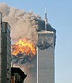 United Airlines Flight 175 crashes into the South Tower of the World Trade Center during the September 11 attacks. (from History of New York (state))
 -
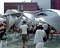 SUR by Xefirotarch at the P.S.1 Contemporary Art Center in Queens (from Culture of New York City)
 -
-
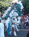 The West Indian Labor Day Parade is an annual carnival along Eastern Parkway in Brooklyn. (from Culture of New York City)
 -
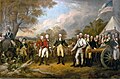 John Trumbull's Surrender of General Burgoyne stylizes the American win at Saratoga. (from History of New York (state))
 -
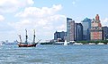 A historical juxtaposition: a replica of Henry Hudson's 17th-century Halve Maen passes modern-day lower Manhattan where the original ship would have sailed while investigating New York Harbor. (from History of New York (state))
 -
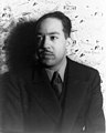 Langston Hughes was part of the Harlem Renaissance that flourished in the 1920s. (from Culture of New York City)
 -
 Flooding on Avenue C in Lower Manhattan caused by Hurricane Sandy. (from History of New York (state))
 -
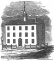 The Stadt Huys in Albany became the state's seat of government when Albany became the permanent capitol in 1797. (from History of New York (state))
 -
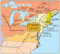 Map of the Province of New York. (from History of New York (state))
 -
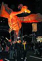 A Phoenix rises to new life at the Village Halloween Parade fifty days after the September 11, 2001, terrorist attacks (from Culture of New York City)
 -
-
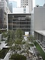 The Yoshio Taniguchi building at the Museum of Modern Art (from Culture of New York City)
 -
 Street vendors at the Feast of San Gennaro in Manhattan's Little Italy (from Culture of New York City)
 -
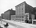 Companies such as Eastman Kodak (Rochester headquarters pictured ca. 1900) epitomized New York's manufacturing economy in the late 19th century. (from History of New York (state))
 -
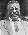 Theodore Roosevelt (from History of New York (state))
 -
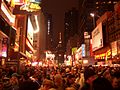 A crowd in Times Square awaits the countdown to the start of 2006. (from Culture of New York City)
 -
-
 A frameworker tightens bolts on the Empire State Building in 1930; the recently completed Chrysler Building is seen in the background. (from History of New York (state))
 -


.jpg?lang=en)
Selected quote -
 Featured article -
.jpeg?lang=en)
John Joseph McGraw (April 7, 1873 – February 25, 1934) was an American Major League Baseball (MLB) player and manager who was for almost thirty years manager of the New York Giants. He was also the third baseman of the pennant-winning 1890s Baltimore Orioles teams, noted for their innovative, aggressive play.
McGraw was born into poverty in Truxton, New York. He found an escape from his hometown and a bad family situation through baseball, beginning a quick rise through the minor leagues that led him to the Orioles at the age of 18. Under the tutelage of manager Ned Hanlon, the Orioles of the 1890s won three National League (NL) pennants; McGraw was one of the stalwarts of the team alongside Wee Willie Keeler, Hughie Jennings, and Wilbert Robinson. The Orioles perfected the hit and run play and popularized the Baltimore chop; they also sought to win by intimidating the opposing team and the umpire. (Full article...)Selected picture -

A sketch published by Nashville Tennessee News sketch of Theodore Roosevelt inauguration minus the customary Bible. Theodore Roosevelt, Jr. (October 27, 1858 – January 6, 1919), also known as T.R., and to the public (but never to friends and intimates) as Teddy, was the twenty-sixth President of the United States, and a leader of the Republican Party.
In the news

- June 16: Wikinews interviews candidate for New York City mayor Vitaly Filipchenko
- August 13: Water main bursts in White Plains, New York, US
- June 19: On the campaign trail in the USA, May 2020
- February 15: California lawyer Michael Avenatti convicted of attempted extortion
- October 17: Hundreds arrested for 'dark web' child porn by international task force
- October 10: U.S. judge orders release of President Trump's tax records, appeals court issues delay
- September 29: Fiancée of murdered Saudi journalist demands justice at UN General Assembly
- September 21: NYC Mayor de Blasio ends US presidential campaign
Did you know? -

- ...that contrary to some beliefs, the Battle of Plattsburgh was decided by the naval engagement and not other means?
- ...that Hawker v. New York is a law preventing convicted felons from practicing medicine, even when the felony conviction occurred before the law was enacted, as decided by the Supreme Court of the United States?
- ...that Representatives of the Albany Congress met on a daily basis between June 19 and July 11 to discuss better relations with the Indian tribes and common defensive measures against the French?
June selected anniversaries

- Ruth Atkinson Ford, born Ruth Atkinson (June 2, 1918 – May 31, June 1, or June 15, 1997) was a pioneering female cartoonist and comic book artist, raised in New York, who helped create the long-running Marvel Comics characters Millie the Model and Patsy Walker.
- Kevin Burns (born June 18, 1955 in Schenectady, New York) is an Emmy Award-winning American television and film producer, director, and screenwriter.
- Francis Marion McDowell (June 12, 1831 in Wayne, New York – March 22, 1894) was an American banker and farmer and a co-founder of the National Grange.
Selected panorama -

The Elting Memorial Library is the main library for the village and town of New Paltz, New York. It is located at 93 Main Street (also NY 32 and 299) in the village's downtown section. The old stone house that originally served as the library has since been added on to, and much of the library's collection and its main circulation desk are housed in this new wing. It has been on the National Register of Historic Places since 2004.
Topics
Categories

Recognized content
| This is a list of recognized content, updated weekly by JL-Bot (talk · contribs) (typically on Saturdays). There is no need to edit the list yourself. If an article is missing from the list, make sure it is tagged (e.g. {{WikiProject New York (state)}}) or categorized correctly and wait for the next update. See WP:RECOG for configuration options. |
Featured articles
 55 Wall Street
- 270 Park Avenue (1960–2021)
- December 1969 nor'easter
- Christmas 1994 nor'easter
- 2006 Westchester County tornado
- 2009 International Bowl
- 2009 New York's 20th congressional district special election
- Aaliyah
- Albany Charter half dollar
- American Airlines Flight 11
- American Bank Note Company Printing Plant
- Art Deco architecture of New York City
- Chester A. Arthur
- Tropical Storm Barry (2007)
- Battle of Ticonderoga (1759)
- Moe Berg
- Briarcliff Manor, New York
- David Hillhouse Buel (priest)
- Mariah Carey
- The Cat and the Canary (1927 film)
- Frances Cleveland
- Grover Cleveland
- Stephen Crane
- Enrico Fermi
- Millard Fillmore
- Eunice Newton Foote
- Joseph B. Foraker
- Fort Ticonderoga
- Horace Greeley
- Jake Gyllenhaal
- Maggie Gyllenhaal
- Here Is Mariah Carey
- Philip Seymour Hoffman
- Hudson Sesquicentennial half dollar
- Hudson Valley Rail Trail
- Anne Hutchinson
- James II of England
- Derek Jeter
- Joppenbergh Mountain
- Sandy Koufax
- Ursula K. Le Guin
- Live and Let Die (novel)
- Low Memorial Library
- 1955 MacArthur Airport United Air Lines crash
- John McGraw
- Assassination of William McKinley
- New Rochelle 250th Anniversary half dollar
- New York State Route 22
- New York State Route 28
- New York State Route 28N
- New York State Route 32
- New York State Route 174
- New York State Route 175
- New York State Route 308
- New York State Route 311
- Niagara Falls Suspension Bridge
- Oakwood Cemetery (Troy, New York)
- 1991 Perfect Storm
- Providence and Worcester Railroad
- RKO Pictures
- Isidor Isaac Rabi
- Riegelmann Boardwalk
- Rosendale Trestle
- Rex Ryan
- William H. Seward
- Elliott Fitch Shepard
- Harry F. Sinclair House
- State Route 343 (New York−Connecticut)
- New Paltz station
- Statue of Liberty
- Capture of Fort Ticonderoga
- Harriet Tubman
- Battle of Valcour Island
- Mary van Kleeck
- Barry Voight
- Walden–Wallkill Rail Trail
- Felix M. Warburg House
- P. G. Wodehouse
- Robert Sterling Yard
Featured lists
- 1970 NBA expansion draft
- List of highways in Warren County, New York
- List of winners of the New York City Marathon
- List of Buffalo Bills head coaches
- List of Buffalo Sabres head coaches
- List of Buffalo Sabres players
- List of Nobel laureates affiliated with Columbia University as alumni or faculty
- List of Roman Catholic archbishops of New York
- List of State University of New York units
- List of counties in New York
- List of tallest buildings in New York City
- Order of battle of the Battle of Long Island
- Lou Gehrig Memorial Award
- List of New York hurricanes
- List of governors of New York
- List of presidents of New York University
- Timeline of Briarcliff Manor
- List of international goals scored by Abby Wambach
Good articles
 2nd Canadian Regiment
- 14th Street Tunnel shutdown
- 15 Central Park West
- 116th Street–Columbia University station
- 140 Broadway
- 370 Jay Street
- 750 Seventh Avenue
- 1893 New York hurricane
- 1912–1913 Little Falls textile strike
- 1920 Buffalo All-Americans season
- 1973–74 Buffalo Braves season
- 1973 Belmont Stakes
- 1973 Buffalo Bills season
- 1974–75 Buffalo Braves season
- 1974–75 Buffalo Sabres season
- 1975–76 Buffalo Braves season
- July 1989 Northeastern United States tornado outbreak
- 2000 United States Senate election in New York
- 2008 NHL Winter Classic
- 2010 Heluva Good! Sour Cream Dips at the Glen
- 2017 New York City ePrix
- 2018 New York City ePrix
- 2020 New York's 22nd congressional district election
- Nick Abruzzese
- Curtis Aiken
- Coat of arms of Albany, New York
- Albany City Hall
- Albany Free School
- Albany, New York
- Albany Pine Bush
- USS Albany (1846)
- Algonquin Hotel
- All Saints' Episcopal Church (Briarcliff Manor, New York)
- Joseph H. Allen
- Alley Pond Park
- Alma Mater (New York sculpture)
- Amazon HQ2
- Mary Amdur
- The Ansonia
- Johnny Antonelli
- Arbor Hill Historic District–Ten Broeck Triangle
- Arden Valley Road
- Armageddon (2008)
- Astoria Park
- Attack on German Flatts (1778)
- Austin, Nichols and Company Warehouse
- Avianca Flight 052
- William Bliss Baker
- Patricia Banks Edmiston
- Barracuda Lounge
- Ed Barrow
- Barryville–Shohola Bridge
- Battle of Bennington
- Battle of Oriskany
- Battle of Cobleskill
- Battle of Fort Anne
- Battle of Fort Washington
- Battle of Harlem Heights
- Battle of Long Island
- Battle of Setauket
- Battle of Staten Island
- Battle of White Plains
- Battle on Snowshoes
- Battles of Saratoga
- Beechwood (Vanderlip mansion)
- John Beilein
- Richard Coote, 1st Earl of Bellomont
- Ann Eliza Bleecker
- Jessie Bonstelle
- Boot Monument
- Bowery Savings Bank Building (130 Bowery)
- Boxers NYC Washington Heights
- James T. Brady
- Tawana Brawley rape allegations
- Briarcliff College
- Briarcliff Farms
- Briarcliff High School
- Briarcliff Lodge
- Briarcliff Manor Fire Department
- Briarcliff Manor Public Library
- Briarcliff Manor Union Free School District
- Brooklyn Botanic Garden
- Dan Brouthers
- Pavel Buchnevich
- Buffalo, New York
- William Burnet (colonial administrator)
- Wellington R. Burt
- James Cagney
- Canajoharie Creek
- Candler Building (New York City)
- Joseph A. Canning
- La Caravelle (New York City)
- Andrew Carnegie Mansion
- Center Square/Hudson–Park Historic District
- Central Park
- Central Troy Historic District
- Ice Box Chamberlain
- Cherry Valley massacre
- Shirley Chisholm
- Chittenango ovate amber snail
- Francis Pharcellus Church
- Chyna
- Rose Cleveland
- Bill Clinton
- The Cock
- Eileen Collins
- 2021–2022 Columbia University strike
- Coney Island
- Dwayne Cooper
- John E. Corbally
- Patrick Corbin
- Cornell Botanic Gardens
- County Route 106 (Rockland County, New York)
- Crowne Plaza Times Square Manhattan
- The Culinary Institute of America
- Cushing House
- Daily News Building
- Richard J. Daronco
- Joseph Dart
- Honey Davenport
- Bruce Davidson (equestrian)
- Davison House
- Nina Davuluri
- Johnston de Peyster
- Death and funeral of Babe Ruth
- December 2013 Spuyten Duyvil derailment
- Murder of Bianca Devins
- William J. Devlin
- Robert Dirks
- Dongan Charter
- Alphonsus J. Donlon
- Downtown Ossining Historic District
- Dr. Holbrook's Military School
- Crystal Dunn
- E (New York City Subway service)
- East Side Access
- Eastern Air Lines Flight 663
- Edward M. Cotter (fireboat)
- Effects of Hurricane Floyd in New York
- Effects of Hurricane Isabel in New York and New England
- Eighth Grade (film)
- Electric Company (football)
- Ely Hall
- William J. Ennis
- Entranceway at Main Street at Roycroft Boulevard
- Entranceways at Main Street at Lamarck Drive and Smallwood Drive
- Esopus Creek
- Ethan Allen Express
- Arthur Eve
- Johnny Evers
- Thomas Farrell (United States Army officer)
- Fellows v. Blacksmith
- Bob Ferguson (infielder)
- Geraldine Ferraro
- Tina Fey
- Abigail Fillmore
- First American International Road Race
- First Battery Armory
- Hamilton Fish
- Val Logsdon Fitch
- Flaco (owl)
- Floyd Bennett Field
- Flushing Meadows–Corona Park
- Jerry Fodor
- Fonteyn Kill
- Siege of Fort Ticonderoga (1777)
- Battle of Forts Clinton and Montgomery
- Four Seasons Restaurant
- James Franco
- The French Connection (ice hockey)
- Frick Collection
- Milton Friedman
- Frontier Central School District
- Klaus Fuchs
- Gertrude Rhinelander Waldo House
- Kirsten Gillibrand
- Ruth Bader Ginsburg
- Kate Gleason
- Glenwood Generating Station
- Maria Goeppert Mayer
- Golos Truda
- Dennis Gorski
- Stephen Jay Gould
- Grand Central Terminal
- Mike Gravel
- Mallory Hagan
- Ray Hall (basketball)
- Alexander Hamilton
- William S. Hamilton
- Edward A. Hanna
- Harriman station (Erie Railroad)
- Abram Lincoln Harris
- Hart Island
- Joseph Hazelwood
- Heckscher State Parkway
- Helmsley Building
- Henry Clay Frick House
- Lorena Hickok
- Lauryn Hill
- Joseph J. Himmel
- History of Cornell University
- History of Briarcliff Manor
- Hotel Chelsea
- Hotel McAlpin
- Louis Howe
- Hudson River
- Huletts Landing, New York
- Shane Hurlbut
- Tillinghast L'Hommedieu Huston
- Hutchinson River Parkway
- Hyatt Grand Central New York
- In Your House 1
- Independent Democratic Conference
- Industry Bar
- International Aviation Meet at Belmont Park
- Interstate 87 (New York)
- Interstate 190 (New York)
- Interstate 287
- Invasion of Quebec (1775)
- The Irishman
- Washington Irving
- James A. Burden House
- Caitlyn Jenner
- Jewett House
- George McTurnan Kahin
- Jack Kemp
- PS Keystone State
- Joyce Kilmer
- Landing at Kip's Bay
- Kissena Creek
- Knife Edge Two Piece 1962–65
- Seymour H. Knox I
- Harold Kushner
- Lafayette Park Historic District
- Lafayette Square (Buffalo, New York)
- Lake Ontario Ordnance Works
- Lathrop House (Vassar College)
- Walter W. Law
- Lexington Hotel (New York City)
- Loop Parkway
- Sid Luckman
- Lucky and Squash
- John Van Antwerp MacMurray
- Sal Maglie
- Sean Patrick Maloney
- Sandro Mamukelashvili
- Manhattan House
- Manhattan
- Marcellus Formation
- Nancy Marcus
- James C. Marshall
- Ashley Massaro
- Massena Terminal Railroad
- Jack F. Matlock Jr.
- Steven Matz
- Mary Arthur McElroy
- Jason McElwain
- Priscilla Johnson McMillan
- Meadowbrook State Parkway
- Meigs Raid
- SS Merchant
- Metropolitan Life Insurance Company Tower
- Millennium Times Square New York
- Aaron Miller (ice hockey)
- Mirabito Outdoor Classic
- Montauk Point land claim
- Grandma Moses
- Mural (Julie Mehretu)
- Mark Murphy (American football executive)
- Michael P. Murphy
- Joe Nathan
- IRT New Lots Line
- New York and New Jersey campaign
- USS New York (BB-34)
- New York Biltmore Hotel
- New York Court of Appeals Building
- New York Jets
- New York Public Library Main Branch
- New York State Route 5
- New York State Route 7
- New York State Route 9A
- New York State Route 20SY
- New York State Route 23
- New York State Route 28A
- New York State Route 31
- New York State Route 43
- New York State Route 45
- New York State Route 59
- New York State Route 78
- New York State Route 92
- New York State Route 101
- New York State Route 108
- New York State Route 111
- New York State Route 114
- New York State Route 117
- New York State Route 118
- New York State Route 120A
- New York State Route 120
- New York State Route 128
- New York State Route 129
- New York State Route 132
- New York State Route 134
- New York State Route 141
- New York State Route 146
- New York State Route 164
- New York State Route 173
- New York State Route 210
- New York State Route 216
- New York State Route 217
- New York State Route 284
- New York State Route 292
- New York State Route 293
- New York State Route 306
- New York State Route 312
- New York State Route 335
- New York State Route 344
- New York State Route 361
- New York State Route 375
- New York State Route 376
- New York State Route 402
- New York State Route 448
- New York State Route 598
- New York State Route 878
- New York Yankees
- New York-class battleship
- Newburgh, Dutchess and Connecticut Railroad
- Francis Nicholson
- Joe Nieuwendyk
- Noble train of artillery
- North Shore Towers
- Not My Presidents Day
- Leo J. O'Donovan
- Logan O'Hoppe
- Arthur A. O'Leary
- Alexandria Ocasio-Cortez
- County of Oneida v. Oneida Indian Nation of New York State
- Peter Ostrum
- The Other Woman (2014 film)
- Otsego Lake (New York)
- Our Lady of Pompeii Church (Manhattan)
- Palisades Interstate Parkway
- Park Avenue Armory
- Alton B. Parker
- George N. Parks
- Henry B. Payne
- The Peninsula New York
- Gilbert Perreault
- The Philaletheis Society
- The Place Beyond the Pines
- Michael Plumb
- Pompey stone
- Pond Eddy Bridge
- Port of Albany–Rensselaer
- Natalie Portman
- Loretta Preska
- Publishers Clearing House
- Q35 (New York City bus)
- Raid on Unadilla and Onaquaga
- James Rainwater
- Norman Ramsey Jr.
- Keith Raniere
- Vic Raschi
- Rector v. Major League Baseball Advanced Media
- Kiliaen van Rensselaer (merchant)
- Rhinebeck and Connecticut Railroad
- Rhinecliff station
- Richmond Hill station (LIRR)
- Dick Rifenburg
- John D. Rockefeller
- Franklin D. Roosevelt
- Rosendale (CDP), New York
- Rosendale Theatre
- Murray Rothbard
- Lester Rowe
- Nicholas Russo
- Sagtikos State Parkway
- Edward Said
- St. Mary's Church (Albany, New York)
- St. Mary's-in-Tuxedo Episcopal Church
- St. Patrick's Cathedral (Midtown Manhattan)
- St. Regis New York
- Salt (2010 film)
- Savanna Samson
- Jedediah Sanger
- Saratoga campaign
- Peter Sarsgaard
- Linda Sarsour
- Richard Henry Savage
- Marilyn Saviola
- Saw Mill River
- Scarborough Day School
- Scarborough Historic District
- Scarborough station (Metro-North)
- Norman Schwarzkopf Jr.
- Seeley G. Mudd Chemistry Building
- Seneca Falls Convention
- Seneca Nation of Indians v. Christy
- September 2023 New York floods
- Cy Seymour
- Whitney North Seymour Jr.
- Siege of Fort Stanwix
- Siege of Fort William Henry
- Skinners Falls–Milanville Bridge
- Sleepy Hollow Country Club
- Sloatsburg station
- Joseph Smith
- Battle on Snowshoes (1757)
- Snyder, New York
- Sonia Sotomayor
- South End–Groesbeckville Historic District
- Elizabeth Cady Stanton
- State Route 346 (New York–Vermont)
- Staten Island Peace Conference
- Statue of James S. T. Stranahan
- Stonewall Inn
- Stork Club
- Students' Building (Vassar College)
- Syracuse University Alma Mater
- Syracuse University
- Martin F. Tanahey
- Henry Taube
- Telluride House
- Tesla, Inc.
- Al Thake
- Therapy (New York City)
- Third Onondaga County courthouse
- Antoine Thompson
- Obi Toppin
- Trump National Golf Club Westchester
- Taro Tsujimoto
- U.S. Route 4 in New York
- Underground World Home
- Unisphere
- United Rentals 176 at The Glen
- United States v. McMahon
- Harold Urey
- Utica, New York
- Valhalla train crash
- Van Tran Flat Bridge
- The View (talk show)
- William Vitarelli
- Marquise Walker
- Wallkill Valley Rail Trail
- Nina de Creeft Ward
- Pop Warner
- PS Washington Irving
- Washington Park Historic District (Albany, New York)
- Max Weinberg
- Murder of Peter Weinberger
- West Kill
- Jamaal Westerman
- Elmer White
- Walt Whitman
- John Wieting
- Wieting Opera House
- The Wilbraham
- Bradley Winslow
- WNYO-TV
- The Wolf of Wall Street (2013 film)
- Woodstock 50
- Woolworth Building
- Chien-Shiung Wu
Related portals
State facts
- Nicknames: The Empire State, The Excelsior State
- Capital: Albany
- Governor: Kathy Hochul (D)
- Lieutenant Governor: Antonio Delgado (D)
- Secretary of State: Robert J. Rodriguez (D)
- Attorney General: Letitia James (D)
- Total area: 54,555 mi2
- Land: 47,190 mi2
- Water: 7,365 mi2
- Highest elevation: 5,344 ft (Mount Marcy)
- Population 19,745,289 (2016 est)
- Admission to the Union: July 26, 1788 (11th)
State symbols:
- Animal: Beaver
- Bird: Eastern Bluebird
- Colors: Blue & Gold
- Freshwater Fish: Brook trout
- Saltwater Fish: Striped bass
- Flower: Rose
- Fossil: Eurypterus remipes
- Insect: Nine-spotted Ladybug
- Songs: "I Love New York"
- Tree: Sugar Maple
- Gem: Garnet
WikiProjects

- Main project
- Specific topics
Things you can do

- Requested articles: Hinduism in New York
- Help assess articles supported by WikiProject New York (state)
- Help suggest content for usage in this portal by using the archive links to obtain instructions
- Write New York topics if you see a redlink which is worthy of an article
- Cleanup and expand stub-class articles relating to New York
Associated Wikimedia
The following Wikimedia Foundation sister projects provide more on this subject:
-
 Commons
Free media repository -
 Wikibooks
Free textbooks and manuals -
 Wikidata
Free knowledge base -
 Wikinews
Free-content news -
 Wikiquote
Collection of quotations -
 Wikisource
Free-content library -
 Wikiversity
Free learning tools -
 Wikivoyage
Free travel guide -
 Wiktionary
Dictionary and thesaurus


