Kalina, Silesian Voivodeship
Jump to navigation
Jump to search
Kalina | |
|---|---|
Village | |
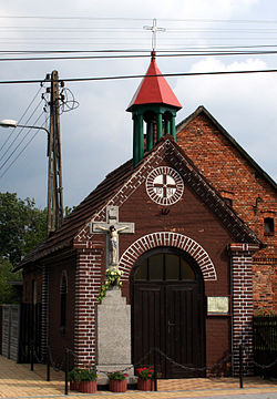
 Kalina Chapel. | |
| Coordinates: 50°43′N 18°52′E / 50.717°N 18.867°E | |
| Country | |
| Voivodeship | Silesian |
| County | Lubliniec |
| Gmina | Herby |
| Population | 381 |
Kalina [kaˈlina] is a village in the administrative district of Gmina Herby, within Lubliniec County, Silesian Voivodeship, in southern Poland.[1] It lies approximately 14 kilometres (9 mi) east of Lubliniec and 53 km (33 mi) north of the regional capital Katowice.
History
[edit]Kalina was previously a separate commune, and the town of Herby, today the seat of the commune, was part of the Kalina commune.
The village is administered by the Catholic Church and falls under the Olszyna parish
Whirlwind
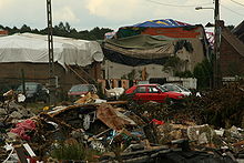
[edit]On August 15, 2008, around 5:24 p.m., a tornado passed over the town, damaging several dozen houses.


Transport
[edit]By car
[edit]You can drive through the village on DW 905
Public Transport
[edit]In the village, near the chapel, there is a bus stop which is rarely used anyway.
References
[edit]
