Gröden
(Redirected from Gröden (Brandenburg))
Gröden | |
|---|---|
 Church in Gröden | |
 Coat of arms | |
Location of Gröden within Elbe-Elster district  | |
 Gröden  Gröden | |
| Coordinates: 51°23′59″N 13°34′00″E / 51.39972°N 13.56667°E | |
| Country | Germany |
| State | Brandenburg |
| District | Elbe-Elster |
| Municipal assoc. | Schradenland |
| Government | |
| • Mayor (2024–29) | Sebastian Rick[1] (CDU) |
| Area | |
| • Total | 22.14 km2 (8.55 sq mi) |
| Elevation | 112 m (367 ft) |
| Population (2022-12-31)[2] | |
| • Total | 1,326 |
| • Density | 60/km2 (160/sq mi) |
| Time zone | UTC+01:00 (CET) |
| • Summer (DST) | UTC+02:00 (CEST) |
| Postal codes | 04932 |
| Dialling codes | 035343 |
| Vehicle registration | EE, FI, LIB |
| Website | www.gemeinde-groeden.de |
Gröden is a municipality in the Elbe-Elster district, in Brandenburg, Germany.
History
[edit]From 1952 to 1990, Gröden was part of the Bezirk Cottbus of East Germany.
Demography
[edit]-
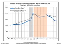 Development of Population since 1875 within the Current Boundaries (Blue Line: Population; Dotted Line: Comparison to Population Development of Brandenburg state; Grey Background: Time of Nazi rule; Red Background: Time of Communist rule)
|
|
|
References
[edit]- ^ Landkreis Elbe-Elster Wahl der Bürgermeisterin / des Bürgermeisters. Retrieved 27 June 2024.
- ^ "Bevölkerungsentwicklung und Bevölkerungsstandim Land Brandenburg Dezember 2022" (PDF). Amt für Statistik Berlin-Brandenburg (in German). June 2023.
- ^ Detailed data sources are to be found in the Wikimedia Commons.Population Projection Brandenburg at Wikimedia Commons
Towns and municipalities in Elbe-Elster | ||
|---|---|---|
|  | |
| Authority control databases: National |
|---|
This Brandenburg location article is a stub. You can help Wikipedia by expanding it. |