Ghughari
Jump to navigation
Jump to search
This article may require copy editing for grammar, style, cohesion, tone, or spelling. (June 2024) |
Ghughari | |
|---|---|
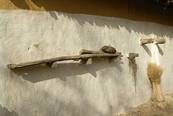
 House in village | |
| Coordinates: 22°41′N 80°41′E / 22.68°N 80.69°E |
Ghughari is a village and a Tehsil Headquarter and a Development Block in Mandla District. It's Situated on Bank of Burhner River that's tributary of Narmada River.[1] Ghughari is located on Latitude: 22° 68" N Longitude: 80° 69" E. Ghughari is 35 km away from Mandla .[2]
Ghughari town has population of 3760 of which 1915 are males while 1845 are females as Census 2011.with total 964 families residing.In 2011 literacy rate of Ghughari village was 83.48 % [3]
The main occupation of the people here is agriculture. Most people grow coarse grains and wheat. This area is a tribal dominated area.[4]
See also
[edit]References
[edit]- ^ "उपखंड | जिला प्रशासन मंडला, मध्यप्रदेश शासन | भारत" (in Hindi). Archived from the original on 2024-03-04. Retrieved 2024-06-27.
- ^ "Maps, Weather, and Airports for Ghugri, India". www.fallingrain.com. Archived from the original on 2022-09-30. Retrieved 2024-06-27.
- ^ "Ghughari Village Population - Ghughari - Mandla, Madhya Pradesh". www.census2011.co.in. Archived from the original on 2024-06-28. Retrieved 2024-06-27.
- ^ "MP Trade Portal". www.mptradeportal.org. Archived from the original on 2024-06-27. Retrieved 2024-06-27.
