File:Jenny Hurn map.png
Jump to navigation
Jump to search
No higher resolution available.
Jenny_Hurn_map.png (553 × 442 pixels, file size: 343 KB, MIME type: image/png)
Summary
[edit]
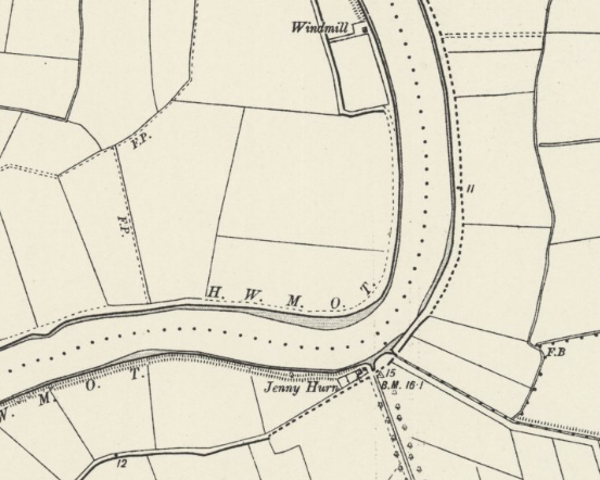
Extract of a pre-1915 Ordnance Survey Map showing Jenny Hurn on the River Trent in Lincolnshire.
| This image is in the public domain in the United States because it was first published outside the United States prior to January 1, 1929. Other jurisdictions have other rules. Also note that this image may not be in the public domain in the 9th Circuit if it was first published on or after July 1, 1909 in noncompliance with US formalities, unless the author is known to have died in 1953 or earlier (more than 70 years ago) or the work was created in 1903 or earlier (more than 120 years ago.)[1] |
 | Do not copy this file to Wikimedia Commons. This file might not be in the public domain outside the United States and should not be transferred to Wikimedia Commons unless it can be verified to be in the public domain in its country of first publication and that at least 70 years have elapsed since the author died. Commons requires that images be free in the source country and in the United States. If this file is in the public domain outside the United States, add |pdsource=yes to this template to hide this warning.If this file is not in the public domain in the source country but will become so in the future, add |out_of_copyright_in= and then the year its copyright will expire. |
File history
Click on a date/time to view the file as it appeared at that time.
| Date/Time | Thumbnail | Dimensions | User | Comment | |
|---|---|---|---|---|---|
| current | 19:24, 26 June 2024 | | 553 × 442 (343 KB) | Dumelow (talk | contribs) | crop |
| 10:38, 26 June 2024 | 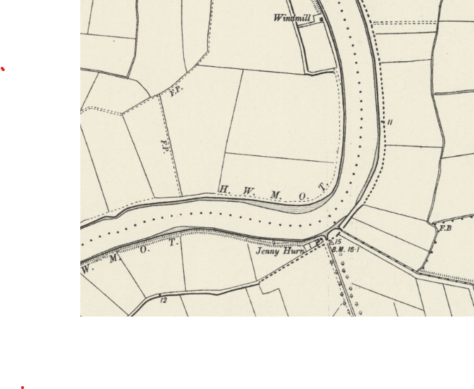 | 673 × 553 (360 KB) | Dumelow (talk | contribs) | Extract of a pre-1915 Ordnance Survey Map showing Jenny Hurn on the River Trent in Lincolnshire. https://maps.nls.uk/geo/explore/side-by-side/#zoom=15.6&lat=53.48100&lon=-0.77869&layers=6&right=ESRIWorld {{Template:PD-US-expired-abroad}} |
You cannot overwrite this file.
File usage
The following pages on the English Wikipedia use this file (pages on other projects are not listed):