Draft:Castledockrell
| Submission declined on 7 February 2024 by Hoary (talk). This submission is not adequately supported by reliable sources. Reliable sources are required so that information can be verified. If you need help with referencing, please see Referencing for beginners and Citing sources.
Where to get help
How to improve a draft
You can also browse Wikipedia:Featured articles and Wikipedia:Good articles to find examples of Wikipedia's best writing on topics similar to your proposed article. Improving your odds of a speedy review To improve your odds of a faster review, tag your draft with relevant WikiProject tags using the button below. This will let reviewers know a new draft has been submitted in their area of interest. For instance, if you wrote about a female astronomer, you would want to add the Biography, Astronomy, and Women scientists tags. Editor resources
|  |
 Comment: Please see my questions/requests in Draft talk:Castledockrell, and respond by improving this draft. Hoary (talk) 00:05, 7 February 2024 (UTC)
Castledockrell
Caisleán Dochraill | |
|---|---|
Village | |
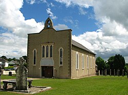
 All Saints Church, Castledockrell | |
| Coordinates: 52°34′59″N 6°36′22″W / 52.583°N 6.606°W |
Castledockrell (Irish: Caisleán Dochraill) is a village in Co. Wexford, Ireland, between the towns of Bunclody and Enniscorthy, off the N80 road.
The place name suggests a historical castle, yet the remains of a scattered wall near the centre of the village is the only potential clue to this.[1]
As of the 2022 census, the population of the rural area of Castledockrell was 502.[2]
Amenities
[edit]In the centre of the village is All Saints' Catholic Church, first built in 1840, and renovated in 1978 to '79.[3] Alongside this is a local community hall. The village has one primary school, Castledockrell N.S.
Completed in 2011, Castledockrell wind farm is comprised of 18 turbines. A scenic walking route along the turbines is open to the public.
References
[edit]- ^ Parish Journal Committee (2003). "unspecified". Marshalstown & Castledockrell Parish Journal. p. 76.
- ^ "Census 2022 - F1018 Population". Central Statistics Office Census 2022 Reports. Retrieved 2024-02-02.
- ^ FUSIO. "All Saints' Catholic Church, MOUNTFIN UPPER, Castledockrell, WEXFORD". National Inventory of Architectural Heritage. Department of Housing, Local Government and Heritage. Retrieved 2024-02-02.
