Cuchilla de Caraguatá
Jump to navigation
Jump to search
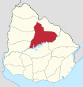
The Cuchilla de Caraguatá is a range of hills in Uruguay.
Location
[edit]It is situated in Uruguay's largest department, Tacuarembó Department, in the north of the country.
Name
[edit]The range of hills gives its name to a village formerly known as Cuchilla de Caraguatá.
The word 'Caraguatá' originally referred to a local plant.
A nearby river is named the Caraguatá River.
Featured in literature
[edit]'Caraguatá' is featured in the poetry of a local writer, Circe Maia.[1] Maia has written a series of poems entitled 'Poemas de Caraguatá', containing reflections to which local topography, flora and fauna have given rise.
See also
[edit]References
[edit]- ^ 'Circe Maia', Wikipedia (in Spanish) es:Circe Maia,
