Brodów Park
| Brodów Park | |
|---|---|
 | |
| Type | Urban park |
| Location | Szczecin, Poland |
| Coordinates | 53°27′38.35″N 14°33′54.31″E / 53.4606528°N 14.5650861°E |
| Area | 10 ha |
| Created | 1970s |
Brodów Park[a] is an urban park in Szczecin, Poland. It is located the neighbourhood of Żelechowa, within the district of Północ, between Obotrycka Street, Pochyła Street, Pochyła Street, Ułańska Street, Żurawia Street, Axentowicza Street, Liściasta Street, and Słowicza Street. It was originally a Lutheran cemetery, closed in 1946, and turned into a park in the 1970s.
Name
[edit]The park was named after the former name of the neighbourhood of Drzetowo, that was Brodów, briefly used after 1945, and related to the former German name Bredow.[1][2]
History
[edit]
The park was established in place of the former Lutheran Drzetowo Cemetery (Polish: Cmentarz Drzetowski; German: Bredower Friedhof), which served the village of Drzetowo, incorporated into Szczecin in 1900. The cemetery had an area of 10 ha. It was renovated and expanded in 1904, and was still operational in the interwar period.[1][3]
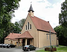
In 1892 there was opened a Lutheran chappel.[4] The cemetery ceased operation in 1946, with its gravestones being used as a building material in the city.[1][3] In 1946, the chapel was turned into the Catholic Church of Our Lady of the Gate of Dawn. On 6 September 2014, there was unveiled a plaque commemorating people that had been buried at that cemetery.[4]
In the 1970s, it was turned into an urban park, further developed as a recreational area in the 1990s.[1][3]
It was renovated in 2018, with numerous recreational amenities being added.[5]
Characteristics
[edit]The park is located the neighbourhood of Żelechowa, within the district of Północ, between Obotrycka Street, Pochyła Street, Pochyła Street, Ułańska Street, Żurawia Street, Axentowicza Street, Liściasta Street, and Słowicza Street. It is placed on the Warszewo Hills, and is covered by a mixed coniferous forest. It has the total area of around 10 ha.[3]
Next to the park, at Słowicza Street, is located the Catholic Church of Our Lady of the Gate of Dawn.[3]
Notes
[edit]References
[edit]- ^ a b c d Tadeusz Białecki, Tadeusz, Lucyna Turek-Kwiatkowska: Szczecin stary i nowy. Encyklopedyczny zarys dziejów historycznych dzielnic i osiedli oraz obiektów fizjograficznych miasta. Szczecin: University of Szczecin, 1991.
- ^ Tadeusz Białecki: Zmiany w nazewnictwie geograficznym Szczecina po 1945 roku. Szczecin: Wydawnictwo Naukowe Uniwersytetu Szczecińskiego, 1995, p. 20. ISBN 83-86745-01-0. (in Polish)
- ^ a b c d e "Park Brodowski". rowery.wzp.pl (in Polish).
- ^ a b "Historia parafii Matki Bożej Ostrobramskiej w Szczecinie". ostrobramska.eparafia.pl (in Polish).
- ^ "Park Brodowski w Szczecinie już gotowy. Jest mnóstwo atrakcji [zdjęcia]". infoludek.pl (in Polish). 20 December 2018.