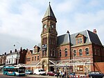
Bootle Village railway station
Bootle Village | |
|---|---|
| General information | |
| Location | Bootle, Metropolitan Borough of Sefton England |
| Coordinates | 53°26′54″N 2°59′46″W / 53.4484°N 2.9960°W |
| Grid reference | SJ339951 |
| Platforms | 2 |
| Other information | |
| Status | Disused |
| History | |
| Original company | Liverpool, Crosby and Southport Railway |
| Pre-grouping | Lancashire and Yorkshire Railway |
| Key dates | |
| 1 October 1850 | Opened as Merton Road |
| Late 1850/early 1851 | Renamed Bootle Village |
| 1 May 1876 | Closed |
Bootle Village railway station was a station in Bootle, Lancashire, England, which opened in 1850 and closed in 1876.
The station opened as Merton Road on 1 October 1850 when the Liverpool, Crosby and Southport Railway (LC&SR) extended its line from Waterloo south into Liverpool. It was renamed within the first few months to try and prevent passengers getting confused and using the East Lancashire Railway's Bootle Lane station, which might have cost the LC&SR revenue. [1][2]
The station was situated on the southern side of Merton Road where it crossed the railway on a bridge, there were two platforms, one each side of the double-track with a station building located on the east side.[3]
The station closed on 1 May 1876 when it, and Miller's Bridge station, were replaced by Bootle Oriel Road which was built between them.[4]
| Preceding station | Historical railways | Following station | ||
|---|---|---|---|---|
| Marsh Lane Line and station (now Bootle New Strand) open |
Lancashire and Yorkshire Railway Liverpool, Crosby and Southport Railway |
Miller's Bridge Line open and station closed | ||
References
[edit]- ^ Gahan 1985, p. 20.
- ^ Quick 2023, p. 93.
- ^ Lancashire Sheet CVI (Map). Six-inch. Ordnance Survey. 1851.
- ^ Quick 2023, p. 319.
Bibliography
[edit]- Gahan, John W. (1985). Seaport to Seaside: Lines to Southport and Ormskirk - 13 decades of trains and travel. ISBN 978-0-907768-07-5.
{{cite book}}: CS1 maint: ignored ISBN errors (link) - Quick, Michael (2023) [2001]. Railway passenger stations in Great Britain: a chronology (PDF). version 5.05. Railway & Canal Historical Society.


