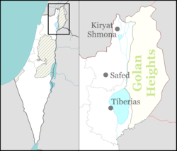
Almagor
Almagor
אַלְמָגוֹר | |
|---|---|
 | |
| Coordinates: 32°54′45″N 35°36′7.56″E / 32.91250°N 35.6021000°E | |
| Country | |
| District | Northern |
| Council | Emek HaYarden |
| Affiliation | Moshavim Movement |
| Founded | 1961 |
| Founded by | Nahal |
| Population (2022)[1] | 425 |
Almagor (Hebrew: אַלְמָגוֹר) is a moshav in northern Israel.[2][3] Located in the Korazim Plateau, to the north of the Sea of Galilee, it falls under the jurisdiction of Emek HaYarden Regional Council. In 2022 it had a population of 425.[1]
Etymology
[edit]The village name is a word combination meaning "lack of fear", al meaning "without", and magor meaning "fear".
History
[edit]The village was established in 1961 as a Nahal settlement and was built on land that had formerly belonged to the depopulated Palestinian villages of Al-Butayha and Arab al-Shamalina.[4] Prior to the foundation of the moshav, the area had been the site for the Battle of Tel Motila, a clash between Israel and Syria on 2 May 1951. Today a large memorial stands at the site.[5]
The village was converted to a civilian settlement in 1965.
References
[edit]- ^ a b "Regional Statistics". Israel Central Bureau of Statistics. Retrieved 21 March 2024.
- ^ Oren, Michael (2010). Six Days of War: June 1967 and the making of the modern Middle East. RosettaBooks. p. 42. ISBN 9780795311857. Retrieved April 19, 2019.
- ^ Wilson, Samantha (2011). Israel (2nd, illustrated ed.). Bradt Travel Guides. ISBN 9781841623627. Retrieved April 19, 2019.
- ^ Khalidi, Walid (1992). All That Remains:The Palestinian Villages Occupied and Depopulated by Israel in 1948. Washington D.C.: Institute for Palestine Studies. pp. 435, 441. ISBN 0-88728-224-5.
- ^ Tel Motila (Kela Hill) Archived 2015-04-02 at the Wayback Machine eKinneret

