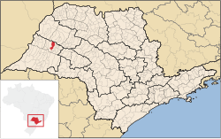
Adamantina
Adamantina | |
|---|---|
 Location in São Paulo state | |
| Coordinates: 21°41′5″S 51°4′24″W / 21.68472°S 51.07333°W | |
| Country | Brazil |
| Region | Southeast |
| State | São Paulo |
| Mesoregion | Presidente Prudente |
| Microregion | Adamantina |
| Government | |
| • Mayor | Ivo Francisco dos Santos Júnior |
| Area | |
| • Total | 412.0 km2 (159.1 sq mi) |
| Elevation | 401 m (1,316 ft) |
| Population (2020 [2]) | |
| • Total | 35,111 |
| • Density | 85/km2 (220/sq mi) |
| Time zone | UTC-03:00 (BRT) |
| • Summer (DST) | UTC-02:00 (BRST) |
| Postal code | 17800-000 |
| Area code | 18 |
| Website | www |
Adamantina is a municipality in the state of São Paulo, Brazil. The population is 35,111 (2020 est.) in an area of 412.0 km2.[1]
History
[edit]The municipality was created by state law in 1948.[3]

Demography
[edit]Population
[edit]Census 2000:
- Total resident : 33,497
- Males: 16,321
- Female: 17,176
- Urban: 30,368 (90.66%)
- Agricultural: 3,129 (9.34%)
Resident population of 10 years or more
- Total: 28.808
Infrastructure
[edit]- Hospitals: 2
- Bank agencies: 9
- Industries: 67
- Commercial Establishments: 279
- Services: 161
- Important places: FAI - Faculdades Adamantinenses Integradas, ETEC "Prof. Eudécio Luiz Vicente", EEPSG "Profª Fleurides Cavallini Menechino", EEPSG "Helen Keller", EEPSG "Durvalino Grion", EEPG "Navarro de Andrade", ACE - Associação Empresarial e Comercial de Adamantina, Recinto Poli Esportivo de Adamantina, Parque dos Pioneiros.[citation needed]
Media
[edit]In telecommunications, the city was served by Telecomunicações de São Paulo.[4] In July 1998, this company was acquired by Telefónica, which adopted the Vivo brand in 2012.[5]
The company is currently an operator of cell phones, fixed lines, internet (fiber optics/4G) and television (satellite and cable).[5]
Religion
[edit]Christianity is present in the city as follows:
Catholic Church
[edit]The Catholic church in the municipality is part of the Roman Catholic Diocese of Marília.[6]
Protestant Church
[edit]The most diverse evangelical beliefs are present in the city, mainly Pentecostal, including the Assemblies of God in Brazil (the largest evangelical church in the country),[7][8] Christian Congregation in Brazil,[9] among others. These denominations are growing more and more throughout Brazil.
See also
[edit]References
[edit]- ^ a b Instituto Brasileiro de Geografia e Estatística
- ^ IBGE 2020
- ^ "Municípios Paulistas". www.al.sp.gov.br (in Portuguese). Retrieved 2024-06-26.
- ^ "Creation of Telesp - April 12, 1973". www.imprensaoficial.com.br (in Portuguese). Retrieved 2024-06-04.
- ^ a b "Our History - Telefônica RI". Telefônica. Retrieved 2024-06-04.
- ^ "São Paulo (Archdiocese) [Catholic-Hierarchy]". www.catholic-hierarchy.org. Retrieved 2024-06-23.
- ^ "Campos Eclesiásticos". CONFRADESP (in Portuguese). 2018-12-10. Retrieved 2024-06-23.
- ^ "Arquivos: Locais". Assembleia de Deus Belém – Sede (in Portuguese). Retrieved 2024-06-23.
- ^ "Localidade - Congregação Cristã no Brasil". congregacaocristanobrasil.org.br (in Portuguese). Retrieved 2024-06-23.
External links
[edit]- (in Portuguese) https://web.archive.org/web/20051107085238/http://www.aquitemagito.com.br/sp/adamantina/ - guide of events of Adamantina.
- (in Portuguese) City government's website


