Timeline of the 2002 Pacific hurricane season: Difference between revisions
MarioJump83 (talk | contribs) Restoring revision 756947717 by Yellow Evan: Do not restore merged articles without consensus. (RW 16) |
Bringing back again Tags: Removed redirect Manual revert Reverted |
||
| Line 1: | Line 1: | ||
{{Tropical cyclone timeline |
|||
#REDIRECT [[2002 Pacific hurricane season]] |
|||
| Name= Timeline of the 2002 Pacific hurricane season |
|||
| Track=2002 Pacific hurricane season summary map.png |
|||
| First date= May 24, 2002 |
|||
| Last date= November 16, 2002 |
|||
| Average wind speed=1 |
|||
| Strongest system=[[Hurricane Kenna|Kenna]] |
|||
| Winds=145 |
|||
| Pressure=913 |
|||
| Longest system=[[Hurricane Fausto (2002)|Fausto]] |
|||
| Total days=8 |
|||
| Five years= [[Timeline of the 2000 Pacific hurricane season|2000]], [[Timeline of the 2001 Pacific hurricane season|2001]], '''2002''', ''[[Timeline of the 2003 Pacific hurricane season|2003]]'', ''[[Timeline of the 2004 Pacific hurricane season|2004]]'' |
|||
| Year = 2002 |
|||
| Basin = EPac |
|||
| Season = Pacific hurricane season |
|||
| Storm1= [[Hurricane Elida (2002)]] |
|||
| Storm2= [[Hurricane Fausto (2002)]] |
|||
| Storm3= [[Hurricane Hernan (2002)]] |
|||
| Storm4= [[Tropical Storm Julio (2002)]] |
|||
| Storm5=[[Hurricane Kenna|Hurricane Kenna (2002)]] |
|||
}} |
|||
The [[2002 Pacific hurricane season]] featured one of the most powerful hurricanes to ever strike the West Mexico coastline in the East Pacific hurricane database on record. Although [[2002 Pacific hurricane season#Hurricane_Alma|Hurricane Alma]] developed on May 24, the season officially began on May 15, 2002 in the eastern Pacific, designated as the area east of 140°[[Longitude|W]], and on June 1, 2002 in the central Pacific, known as the region between the [[International Date Line]] and 140°W. The end of the season for both basins occurred on November 30, although [[2002 Pacific hurricane season#Tropical_Depression_Sixteen-E|Tropical Depression Sixteen-E]] dissipated on November 16. |
|||
The season produced nineteen [[tropical depression]]s, of which fifteen intensified into [[tropical storm]]s, eight became [[Tropical cyclone#Hurricane or typhoon|hurricane]]s, and six became [[Tropical cyclone scales#Atlantic and East Pacific|major hurricane]]s. While many tropical cyclones affected land during the season, [[Hurricane Kenna]] produced the most damage and loss of life. The third most powerful hurricane ever recorded in the East Pacific, Kenna reached maximum sustained winds of 165 mph (270 km/h), but weakened to a minimal Category 4 on the [[Saffir-Simpson Hurricane Wind Scale|Saffir–Simpson Hurricane Wind Scale]] by the time the system moved ashore. |
|||
This timeline includes information that was not operationally released, meaning that data from post-storm reviews by the [[National Hurricane Center]], such as a storm that was not operationally warned upon, has been included. This timeline documents tropical cyclone formations, strengthening, weakening, [[Landfall (meteorology)|landfall]]s, [[extratropical transition]]s, and dissipations during the season. |
|||
==Timeline of events== |
|||
<center> |
|||
<timeline> |
|||
ImageSize = width:800 height:200 |
|||
PlotArea = top:10 bottom:80 right:20 left:20 |
|||
Legend = columns:3 left:30 top:58 columnwidth:270 |
|||
AlignBars = early |
|||
DateFormat = dd/mm/yyyy |
|||
Period = from:01/05/2002 till:01/12/2002 |
|||
TimeAxis = orientation:horizontal |
|||
ScaleMinor = grid:black unit:month increment:1 start:01/05/2002 |
|||
Colors = |
|||
id:canvas value:gray(0.88) |
|||
id:GP value:red |
|||
id:TD value:rgb(0.38,0.73,1) legend:Tropical_Depression_=_<39_mph_(0–62_km/h) |
|||
id:TS value:rgb(0,0.98,0.96) legend:Tropical_Storm_=_39–73_mph_(63–117 km/h) |
|||
id:C1 value:rgb(1,1,0.80) legend:Category_1_=_74–95_mph_(119–153_km/h) |
|||
id:C2 value:rgb(1,0.91,0.46) legend:Category_2_=_96–110_mph_(154–177_km/h) |
|||
id:C3 value:rgb(1,0.76,0.25) legend:Category_3_=_111–129_mph_(178–209-km/h) |
|||
id:C4 value:rgb(1,0.56,0.13) legend:Category_4_=_130–156_mph_(210–249_km/h) |
|||
id:C5 value:rgb(1,0.38,0.38) legend:Category_5_=_>=157_mph_(>=250_km/h) |
|||
Backgroundcolors = canvas:canvas |
|||
BarData = |
|||
barset:Hurricane |
|||
bar:Month |
|||
PlotData= |
|||
barset:Hurricane width:10 align:left fontsize:S shift:(4,-4) anchor:till |
|||
from:24/05/2002 till:01/06/2002 color:C3 text:"Alma (C3)" |
|||
from:08/06/2002 till:11/06/2002 color:TS text:"Boris (TS)" |
|||
from:27/06/2002 till:29/06/2002 color:TD text:"Three-E (TD)" |
|||
from:09/07/2002 till:16/07/2002 color:TS text:"Cristina (TS)" |
|||
from:20/07/2002 till:26/07/2002 color:C2 text:"Douglas (C2)" |
|||
from:23/07/2002 till:30/07/2002 color:C5 text:"[[Hurricane Elida (2002)|Elida (C5)]]" |
|||
from:06/08/2002 till:08/08/2002 color:TD text:"Seven-E (TD)" |
|||
barset:break |
|||
from:21/08/2002 till:28/08/2002 color:C4 text: |
|||
barset:break |
|||
from:31/08/2002 till:03/09/2002 color:TS text:"[[Hurricane Fausto(2002)|Fausto (C4)]]" |
|||
from:22/08/2002 till:28/08/2002 color:TS text:"Alika (TS)" |
|||
from:26/08/2002 till:01/09/2002 color:TS text:"Genevieve (TS)" |
|||
from:26/08/2002 till:30/08/2002 color:C3 text:"Ele (C3)" |
|||
from:30/08/2002 till:06/09/2002 color:C5 text:"[[Hurricane Hernan (2002)|Hernan (C5)]]" |
|||
from:05/09/2002 till:08/09/2002 color:TD text:"Eleven-E (TD)" |
|||
from:15/09/2002 till:20/09/2002 color:TS text:"Iselle (TS)" |
|||
barset:break |
|||
from:25/09/2002 till:26/09/2002 color:TS text:"[[Tropical Storm Julio (2002)|Julio (TS)]]" |
|||
from:22/10/2002 till:26/10/2002 color:C5 text:"[[Hurricane Kenna|Kenna (C5)]]" |
|||
from:22/10/2002 till:31/10/2002 color:TS text:"Lowell (TS)" |
|||
from:24/10/2002 till:03/11/2002 color:C1 text:"Huko (C1)" |
|||
from:30/10/2002 till:31/10/2002 color:TS text:"Maysak (TS)" |
|||
from:14/11/2002 till:16/11/2002 color:TD text:"Sixteen-E (TD)" |
|||
barset:break |
|||
bar:Month width:5 align:center fontsize:S shift:(0,-20) anchor:middle color:canvas |
|||
from:01/05/2002 till:01/06/2002 text:May |
|||
from:01/06/2002 till:01/07/2002 text:June |
|||
from:01/07/2002 till:01/08/2002 text:July |
|||
from:01/08/2002 till:01/09/2002 text:August |
|||
from:01/09/2002 till:01/10/2002 text:September |
|||
from:01/10/2002 till:01/11/2002 text:October |
|||
from:01/11/2002 till:01/12/2002 text:November |
|||
TextData = |
|||
pos:(570,30) |
|||
text:"(From the" |
|||
pos:(617,30) |
|||
text:"[[Saffir–Simpson scale]])" |
|||
</timeline> |
|||
</center> |
|||
===May=== |
|||
[[Image:Hurricane Alma 2002.jpg|thumb|right|Hurricane Alma at strong category 2 hurricane status.]] |
|||
;May 1 |
|||
*0700 [[Coordinated Universal Time|UTC]] (12:00 a.m. [[Pacific Daylight Time|PDT]]) – The Eastern Pacific hurricane season officially begins.<ref name = "AOML FAQ G1">{{cite web | author = [[Atlantic Oceanographic and Meteorological Laboratory]], Hurricane Research Division | title = Frequently Asked Questions: When is hurricane season?|publisher = [[National Oceanic and Atmospheric Administration]] | accessdate = 2008-10-22 | url = http://www.aoml.noaa.gov/hrd/tcfaq/G1.html}}</ref> |
|||
;May 24 |
|||
*1800 UTC (5 a.m. PDT) – Tropical Depression One-E forms 485 miles (900 km) south-southeast of [[Manzanillo, Mexico]].<ref name="Alma">{{cite web|author=National Hurricane Center|year=2002|title=Hurricane Alma Tropical Cyclone Report|accessdate=2008-10-24|url=http://www.nhc.noaa.gov/2002alma.shtml|publisher = [[National Hurricane Center]]}}</ref> |
|||
;May 26 |
|||
*1200 UTC (5 a.m. PDT) – Tropical Depression One-E strengthens into Tropical Storm Alma.<ref name="Alma"/> |
|||
;May 28 |
|||
*1800 UTC (5 a.m. PDT) – Tropical Storm Alma strengthens into a hurricane.<ref name="Alma"/> |
|||
;May 29 |
|||
*1800 UTC (5 a.m. PDT) – Hurricane Alma reaches category 2 strength.<ref name="Alma"/> |
|||
;May 30 |
|||
*0600 UTC (11 a.m. PDT) – Hurricane Alma becomes a major hurricane.<ref name="Alma"/> |
|||
*1800 UTC (5 a.m. PDT) – Hurricane Alma weakens into a category 2 hurricane.<ref name="Alma"/> |
|||
;May 31 |
|||
*0600 UTC (11 p.m. PDT) – Hurricane Alma weakens into a category 1 hurricane.<ref name="Alma"/> |
|||
*1200 UTC (5 a.m. PDT) – Hurricane Alma weakens into a tropical storm.<ref name="Alma"/> |
|||
===June=== |
|||
[[Image:Boris 2002 track.png|thumb|right|Tracking Map of Tropical Storm Boris.]] |
|||
;June 1 |
|||
*The Central Pacific hurricane season officially begins.<ref name="AOML FAQ G1"/> |
|||
*0600 UTC (11 p.m. PDT) – Tropical Storm Alma weakens into a tropical depression.<ref name="Alma"/> |
|||
*1200 UTC (5 a.m. PDT) – Tropical Depression Alma dissipates.<ref name="Alma"/> |
|||
;June 8 |
|||
*1200 UTC (5 a.m. PDT) – Tropical Depression Two-E forms 150 miles (280 km) west-southwest of [[Acapulco, Mexico]].<ref name="Boris">{{cite web|author=National Hurricane Center|year=2002|title=Tropical Storm Boris Tropical Cyclone Report|accessdate=2008-10-24|url=http://www.nhc.noaa.gov/2002boris.shtml|publisher = [[National Hurricane Center]]}}</ref> |
|||
;June 9 |
|||
*0000 UTC (5 p.m. PDT) – Tropical Depression Two-E strengthens into Tropical Storm Boris.<ref name="Boris"/> |
|||
;June 10 |
|||
*1800 UTC (5 a.m. PDT) – Tropical Storm Boris weakens into a tropical depression.<ref name="Boris"/> |
|||
;June 11 |
|||
*1800 UTC (5 a.m. PDT) – Tropical Depression Boris degenerates into a remnant low pressure area.<ref name="Boris"/> |
|||
;June 27 |
|||
*1200 UTC (5 a.m. PDT) – Tropical Depression Three-E forms 970 miles (1795 km) southwest of the southern tip of the [[Baja Peninsula]].<ref name="TD 3-E">{{cite web|author=National Hurricane Center|year=2002|title=TD 3-E Tropical Cyclone Report|accessdate=2008-10-24|url=http://www.nhc.noaa.gov/2002three.shtml|publisher = [[National Hurricane Center]]}} {{Dead link|date=October 2010|bot=H3llBot}}</ref> |
|||
;June 29 |
|||
*0600 UTC (11 p.m. PDT) – Tropical Depression Three-E dissipates.<ref name="TD 3-E"/> |
|||
===July=== |
|||
[[Image:Tropical Storm Cristina 2002.jpg|thumb|right|Image of Tropical Storm Cristina at peak strength.]] |
|||
;July 9 |
|||
*1200 UTC (5 a.m. PDT) – Tropical Depression Four-E forms 300 miles (555 km) south of Acapulco, Mexico.<ref name="Cristina">{{cite web|author=National Hurricane Center|year=2002|title=Tropical Storm Cristina Tropical Cyclone Report|accessdate=2008-10-24|url=http://www.nhc.noaa.gov/2002cristina.shtml|publisher = [[National Hurricane Center]]}}</ref> |
|||
;July 12 |
|||
*0600 UTC (11 p.m. PDT) – Tropical Depression Four-E strengthens into Tropical Storm Cristina.<ref name="Cristina"/> |
|||
;July 15 |
|||
*1200 UTC (5 a.m. PDT) – Tropical Storm Cristina weakens into a tropical depression.<ref name="Cristina"/> |
|||
;July 17 |
|||
*0000 UTC (5 p.m. PDT) – Tropical Depression Cristina dissipates.<ref name="Cristina"/> |
|||
;July 20 |
|||
*1200 UTC (5 a.m. PDT) – Tropical Depression Five-E forms 395 miles (730 km) south of Manzanillo, Mexico.<ref name="Douglas">{{cite web|author=National Hurricane Center|year=2002|title=Hurricane Douglas Tropical Cyclone Report|accessdate=2008-10-24|url=http://www.nhc.noaa.gov/2002douglas.shtml|publisher = [[National Hurricane Center]]}}</ref> |
|||
*1800 UTC (5 a.m. PDT) – Tropical Depression Five-E strengthens into Tropical Storm Douglas.<ref name="Douglas"/> |
|||
;July 22 |
|||
*0000 UTC (5 p.m. PDT) – Tropical Storm Douglas becomes a hurricane.<ref name="Douglas"/> |
|||
*1200 UTC (5 a.m. PDT) – [[Hurricane Douglas (2002)|Hurricane Douglas]] strengthens to become a category 2 hurricane.<ref name="Douglas"/> |
|||
;July 23 |
|||
*0600 UTC (11 p.m. PDT) – Tropical Depression Six-E forms 305 miles (565 km) south-southeast of Puerto Escondido, Mexico.<ref name="Elida">{{cite web|author=National Hurricane Center|year=2002|title=Hurricane Elida Tropical Cyclone Report|accessdate=2008-10-24|url=http://www.nhc.noaa.gov/2002elida.shtml|publisher = [[National Hurricane Center]]}}</ref> |
|||
*1200 UTC (5 a.m. PDT) – Tropical Depression Six-E strengthens into Tropical Storm Elida.<ref name="Elida"/> |
|||
*1800 UTC (5 a.m. PDT) – Hurricane Douglas weakens into a category 1 hurricane.<ref name="Douglas"/> |
|||
[[Image:Hurricane Elida 24 july 2002.jpg|thumb|right|Image of Hurricane Elida near peak strength.]] |
|||
;July 24 |
|||
*0600 UTC (11 p.m. PDT) – Tropical Storm Elida strengthens into a hurricane.<ref name="Elida"/> |
|||
*1200 UTC (5 a.m. PDT) – [[Hurricane Elida (2002)|Hurricane Elida]] strengthens into a major hurricane, skipping category 2 status.<ref name="Elida"/> |
|||
*1800 UTC (5 a.m. PDT) – Hurricane Elida strengthens into a category 4 hurricane.<ref name="Elida"/> |
|||
*1800 UTC (5 a.m. PDT) – Hurricane Douglas weakens into a tropical storm.<ref name="Douglas"/> |
|||
;July 25 |
|||
*0600 UTC (11 p.m. PDT) – Hurricane Elida becomes the first category 5 hurricane of the season.<ref name="Elida"/> |
|||
*1200 UTC (5 a.m. PDT) – Hurricane Elida weakens into a category 4 hurricane.<ref name="Elida"/> |
|||
;July 26 |
|||
*0000 UTC (5 p.m. PDT) – Hurricane Elida weakens into a category 3 hurricane.<ref name="Elida"/> |
|||
*0000 UTC (5 p.m. PDT) – Tropical Storm Douglas weakens into a tropical depression.<ref name="Douglas"/> |
|||
*1800 UTC (5 a.m. PDT) – Hurricane Elida weakens into a category 2 hurricane.<ref name="Elida"/> |
|||
*1800 UTC (5 a.m. PDT) – Tropical Depression Douglas degenerates into a remnant low pressure area.<ref name="Douglas"/> |
|||
;July 27 |
|||
*0600 UTC (11 p.m. PDT) – Hurricane Elida weakens into a category 1 hurricane.<ref name="Elida"/> |
|||
*1800 UTC (5 a.m. PDT) – Hurricane Elida weakens into a tropical storm.<ref name="Elida"/> |
|||
;July 29 |
|||
*1800 UTC (5 a.m. PDT) – Tropical Storm Elida weakens into a tropical depression.<ref name="Elida"/> |
|||
;July 30 |
|||
*1800 UTC (5 a.m. PDT) – Tropical Depression Elida weakens into a remnant low pressure area.<ref name="Elida"/> |
|||
===August=== |
|||
[[Image:Fausto 2002 track.png|thumb|Tracking map of Hurricane Fausto.]] |
|||
;August 6 |
|||
*0000 UTC (5 p.m. PDT) – Tropical Depression Seven-E forms 785 miles (1455 km) southwest of the southern tip of the Baja Peninsula.<ref name="TD 7-E">{{cite web|author=National Hurricane Center|year=2002|title=TD 7-E Tropical Cyclone Report|accessdate=2008-10-24|url=http://www.nhc.noaa.gov/2002seven-e.shtml|publisher = [[National Hurricane Center]]}}</ref> |
|||
;August 8 |
|||
*0600 UTC (11 p.m. PDT) – Tropical Depression Seven-E dissipates.<ref name="TD 7-E"/> |
|||
;August 21 |
|||
*1200 UTC (5 a.m. PDT) – Tropical Depression Eight-E forms 400 miles (740 km) south-southwest of Manzanillo, Mexico.<ref name="Fausto">{{cite web|author=National Hurricane Center|year=2002|title=Hurricane Fausto Tropical Cyclone Report|accessdate=2008-10-24|url=http://www.nhc.noaa.gov/2002fausto.shtml|publisher = [[National Hurricane Center]]}}</ref> |
|||
;August 22 |
|||
*0000 UTC (5 p.m. August 21 PDT) – Tropical Depression Eight-E strengthens into Tropical Storm Fausto.<ref name="Fausto"/> |
|||
*1800 UTC (5 a.m. PDT) – Tropical Storm Fausto becomes a hurricane.<ref name="Fausto"/> |
|||
*1800 UTC (2 a.m. [[Hawaii-Aleutian Standard Time Zone|HST]]) – Tropical Depression One-C forms over 1000 miles (1850 km) south of Hawaii.<ref name="Alika">{{cite web|url=http://www.prh.noaa.gov/cphc/summaries/2002.php#alika|title=Tropical Cyclone Report:Tropical Storm Alika|date=May 2003|publisher=[[Central Pacific Hurricane Center]]|accessdate=2009-04-09}}</ref> |
|||
[[Image:TS Alika 25 aug 2002 2005Z.jpg|Tropical Storm Alika at peak intensity.|thumb]] |
|||
;August 23 |
|||
*1200 UTC (5 a.m. PDT) – Hurricane Fausto becomes a category 2 hurricane.<ref name="Fausto"/> |
|||
*1800 UTC (5 a.m. PDT) – Hurricane Fausto becomes a major hurricane.<ref name="Fausto"/> |
|||
;August 24 |
|||
*0600 UTC (11 p.m. PDT) – Hurricane Fausto becomes a category 4 hurricane.<ref name="Fausto"/> |
|||
;August 25 |
|||
*0000 UTC (2 p.m. August 24 HST) – Tropical Depression One-C strengthens into a tropical storm and is named Alika.<ref name="Alika" /> |
|||
*0600 UTC (11 p.m. PDT) – Hurricane Fausto weakens into a category 3 hurricane.<ref name="Fausto"/> |
|||
*1200 UTC (5 a.m. PDT) – Hurricane Fausto weakens into a category 2 hurricane.<ref name="Fausto"/> |
|||
[[Image:TS Genevieve 2002.jpg|thumb|Image of Tropical Storm Genevieve on August 28, 2002 at peak intensity.]] |
|||
;August 26 |
|||
*0000 UTC (5 p.m. PDT) – Tropical Depression Nine-E forms 500 miles (925 km) south of the Baja Peninsula.<ref name="Genevieve">{{cite web|url=http://www.nhc.noaa.gov/2002genevieve.shtml|title=Tropical Cyclone Report:Tropical Storm Genevieve|last=Avila|first=Lixion A.|date=October 12, 2002|publisher=[[National Hurricane Center]]|accessdate=2009-04-09}}</ref> |
|||
*0600 UTC (11 p.m. PDT) – Hurricane Fausto weakens into a category 1 hurricane.<ref name="Fausto"/> |
|||
*1200 UTC (5 a.m. PDT) – Hurricane Fausto weakens into a tropical storm.<ref name="Fausto"/> |
|||
;August 27 |
|||
*0000 UTC (2 p.m. August 26 HST) – Tropical Depression Two-C forms about 1000 miles (1850 km) southwest of the Hawaiian Islands.<ref name="Ele">{{cite web|url=http://www.prh.noaa.gov/cphc/summaries/2002.php#ele|title=Tropical Cyclone Reports:Hurricane Ele|date=May 2003|publisher=[[Central Pacific Hurricane Center]]|accessdate=2009-04-09}}</ref> |
|||
*0000 UTC (5 p.m. PDT) – Tropical Depression Nine-E strengthens into a tropical storm and is named Genevieve.<ref name="Genevieve" /> |
|||
*0000 UTC (2 p.m. August 26 HST) – Tropical Storm Alika weakens into a tropical depression.<ref name="Alika" /> |
|||
*0600 UTC (8 p.m. HST) – Tropical Depression Two-C strengthens into a tropical storm and is named Ele.<ref name="Ele" /> |
|||
[[Image:Typhoon ele 2002 august 30.jpg|thumb|Hurricane Ele as it moved out of the Central Pacific Hurricane Center's Area of Responsibility.]] |
|||
;August 28 |
|||
*0000 UTC (2 p.m. August 27 HST) – [[Hurricane Ele (2002)|Tropical Storm Ele]] strengthens into a hurricane.<ref name="Ele" /> |
|||
*0000 UTC (5 p.m. PDT) – Tropical Storm Fausto weakens into a tropical depression as it crosses into the Central Pacific.<ref name="Fausto"/> |
|||
*0600 UTC (8 p.m. August 27 HST) – Tropical Depression Alika dissipates.<ref name="Alika" /> |
|||
*1200 UTC (5 a.m. PDT) – Tropical Depression Fausto degenerates into a low.<ref name="Fausto"/> |
|||
;August 29 |
|||
*0600 UTC (8 p.m. August 28 HST) – Hurricane Ele strengthens into a category 2 hurricane.<ref name="Ele" /> |
|||
*1800 UTC (2 a.m. HST) – Hurricane Ele strengthens into a major hurricane.<ref name="Ele" /> |
|||
;August 30 |
|||
*0000 UTC (2 p.m. August 29 HST) – Hurricane Ele moves out of the Central Pacific and into the West Pacific where the [[Japan Meteorological Agency|JMA]] takes up warning responsibility.<ref name="Ele" /> |
|||
*0600 UTC (11 p.m. PDT) – Tropical Depression Ten-E forms 340 miles (630 km) south-southwest of Manzanillo, Mexico.<ref name="Hernan">{{cite web|url=http://www.nhc.noaa.gov/2002hernan.shtml|title=Tropical Cyclone Report:Hurricane Hernan|last=Lawrence|first=Miles B.|date=December 12, 2002|publisher=[[National Hurricane Center]]|accessdate=2009-04-09}}</ref> |
|||
*1200 TC (5 a.m. PDT) – Tropical Depression Ten-E strengthens into a tropical storm and is named Hernan.<ref name="Hernan" /> |
|||
*1200 UTC (5 a.m. PDT) – Tropical Storm Genevieve weakens into a tropical depression.<ref name="Genevieve" /> |
|||
*1800 UTC (5 a.m. PDT) – Tropical Depression Fausto regenerates about 430 miles (795 km) north of the Hawaiian Islands.<ref name="Fausto"/> |
|||
;August 31 |
|||
*0600 UTC (11 p.m. PDT) – Tropical Storm Hernan becomes a hurricane.<ref name="Hernan"/> |
|||
*1200 UTC (5 a.m. PDT) – Hurricane Hernan strengthens into a category 2 hurricane.<ref name="Hernan"/> |
|||
*1800 UTC (5 a.m. PDT) – Hurricane Hernan strengthens into a major hurricane.<ref name="Hernan"/> |
|||
===September=== |
|||
;September 1 |
|||
*0000 UTC (5 p.m. PDT) – Hurricane Hernan strengthens into a category 4 hurricane.<ref name="Hernan"/> |
|||
*0600 UTC (11 p.m. PDT) – Tropical Depression Genevieve dissipates.<ref name="Genevieve"/> |
|||
*1200 UTC (5 a.m. PDT) – Hurricane Hernan strengthens into a category 5 hurricane.<ref name="Hernan"/> |
|||
*1800 UTC (5 a.m. PDT) – Tropical Depression Fausto re-strengthens into a tropical storm.<ref name="Fausto"/> |
|||
[[Image:Hernan 2002 track.png|Tracking map of Hurricane Hernan.|thumb]] |
|||
;September 2 |
|||
*0000 UTC (5 p.m. PDT) – Hurricane Hernan weakens into a category 4 hurricane.<ref name="Hernan"/> |
|||
*1200 UTC (5 a.m. PDT) – Hurricane Hernan weakens into a category 3 hurricane.<ref name="Hernan"/> |
|||
;September 3 |
|||
*0000 UTC (5 p.m. PDT) – Hurricane Hernan weakens into a category 2 hurricane.<ref name="Hernan"/> |
|||
*0600 UTC (11 p.m. PDT) – Tropical Storm Fausto is absorbed by an extratropical low.<ref name="Fausto"/> |
|||
;September 4 |
|||
*0000 UTC (5 p.m. PDT) – Hurricane Hernan weakens into a category 1 hurricane.<ref name="Hernan"/> |
|||
*1200 UTC (5 a.m. PDT) – Hurricane Hernan weakens into a tropical storm.<ref name="Hernan"/> |
|||
;September 5 |
|||
*1200 UTC (5 a.m. PDT) – Tropical Storm Hernan weakens into a tropical depression.<ref name="Hernan"/> |
|||
;September 6 |
|||
*0000 UTC (5 p.m. PDT) – Tropical Depression Eleven-E forms 120 miles (220 km) southwest of Cabo Corrientes, Mexico.<ref name="TD 11-E">{{cite web|url=http://www.nhc.noaa.gov/2002eleven-e.shtml|title=Tropical Cyclone Report:Tropical Depression Eleven-E|last=Pasch|first=Richard J.|date=January 13, 2003|publisher=[[National Hurricane Center]]|accessdate=2009-04-09}}</ref> |
|||
*1800 UTC (5 a.m. PDT) – Tropical Depression Hernan weakens into a remnant low pressure area.<ref name="Hernan"/> |
|||
;September 8 |
|||
*1800 UTC (5 a.m. PDT) – Tropical Depression Eleven-E weakens into a remnant low pressure area.<ref name="TD 11-E" /> |
|||
;September 15 |
|||
*0600 UTC (11 p.m. PDT) – Tropical Depression Twelve-E forms 270 miles (500 km) south of Manzanillo, Mexico.<ref name="Iselle">{{cite web|url=http://www.nhc.noaa.gov/2002iselle.shtml|title=Tropical Cyclone Report:Tropical Storm Iselle|last=Stewart|first=Stacy R.|date=November 10, 2002|publisher=[[National Hurricane Center]]|accessdate=2009-04-09}}</ref> |
|||
[[Image:TS Iselle 2002.jpg|thumb|Image of Tropical Storm Iselle at peak intensity.]] |
|||
;September 16 |
|||
*0000 UTC (5 p.m. PDT) – Tropical Depression Twelve-E strengthens into a tropical storm and is named Iselle.<ref name="Iselle" /> |
|||
;September 19 |
|||
*1800 UTC (5 a.m. PDT) – Tropical Storm Iselle weakens into a tropical depression.<ref name="Iselle" /> |
|||
;September 20 |
|||
*0600 UTC (11 p.m. PDT) – Tropical Depression Iselle weakens into a remnant low pressure area.<ref name="Iselle" /> |
|||
[[Image:Julio 2002 track.png|Tracking map of Tropical Storm Julio.|thumb]] |
|||
;September 25 |
|||
*0000 UTC (5 p.m. PDT) – Tropical Depression Thirteen-E forms 175 miles (325 km) southwest of Acapulco, Mexico.<ref name="Julio">{{cite web|url=http://www.nhc.noaa.gov/2002julio.shtml|title=Tropical Cyclone Report:Tropical Storm Julio|last=Beven|first=Jack|date=December 11, 2002|publisher=[[National Hurricane Center]]|accessdate=2009-04-09}}</ref> |
|||
*1200 UTC (5 a.m. PDT) – Tropical Depression Thirteen-E strengthens into a tropical storm and is named Julio.<ref name="Julio" /> |
|||
;September 26 |
|||
*0000 UTC (5 p.m. PDT) – Tropical Storm Julio makes landfall west-northwest of Lazaro Cardenas, Mexico with winds of 45 mph (70 km/h).<ref name="Julio" /> |
|||
:*1200 UTC (5 a.m. PDT) – Tropical Storm Julio weakens into a tropical depression.<ref name="Julio" /> |
|||
:*1800 UTC (11 a.m. PDT) – Tropical Depression Julio dissipates.<ref name="Julio" /> |
|||
===October=== |
|||
;October 22 |
|||
*0000 UTC (5 p.m. PDT) – Tropical Depression Fourteen-E forms 325 miles (600 km) south of Acapulco, Mexico.<ref name="Kenna">{{cite web|url=http://www.nhc.noaa.gov/2002kenna.shtml|title=Tropical Cyclone Report:Hurricane Kenna|last=Franklin|first=James L.|date=December 26, 2002|publisher=[[National Hurricane Center]]|accessdate=2009-04-09}}</ref> |
|||
*0600 UTC (11 p.m. October 21 PDT) – Tropical Depression Fourteen-E strengthens into a tropical storm and is named Kenna.<ref name="Kenna"/> |
|||
*1800 UTC (5 a.m. PDT) – Tropical Depression Fifteen-E forms in the western portion of the Eastern Pacific.<ref name="Lowell">{{cite web|url=http://www.nhc.noaa.gov/2002lowell.shtml|title=Tropical Cyclone Report: Tropical Storm Lowell|last=Avila|first=Lixion A.|date=December 27, 2002|publisher=[[National Hurricane Center]]|accessdate=2009-04-09}}</ref> |
|||
;October 23 |
|||
*0600 UTC (11 p.m. October 22 PDT) – Tropical Depression Fifteen-E strengthens into a tropical storm and is named Lowell.<ref name="Lowell"/> |
|||
*1800 UTC (5 a.m. PDT) – Tropical Storm Kenna strengthens into a hurricane.<ref name="Kenna"/> |
|||
[[Image:HurricaneKenna2002.jpg|Hurricane Kenna at peak intensity off Mexico.|thumb]] |
|||
;October 24 |
|||
*0000 UTC (5 p.m. October 23 PDT) – Hurricane Kenna strengthens into a category 2 hurricane.<ref name="Kenna"/> |
|||
*0600 UTC (11 p.m. October 23 PDT) – Hurricane Kenna strengthens into a major hurricane.<ref name="Kenna"/> |
|||
*1200 UTC (5 a.m. PDT) – Hurricane Kenna strengthens into a category 4 hurricane.<ref name="Kenna"/> |
|||
*1800 UTC (5 a.m. PDT) – Hurricane Kenna strengthens into a category 5 hurricane.<ref name="Kenna"/> |
|||
*1800 UTC (11 a.m. PDT) – Tropical Storm Lowell weakens into a tropical depression.<ref name="Lowell"/> |
|||
*1800 UTC (2 a.m. PDT) – Tropical Depression Three-C forms south of the Hawaiian Islands.<ref name="Huko">{{cite web|url=http://www.prh.noaa.gov/cphc/summaries/2002.php#huko|title=Tropical Cyclone Report:Hurricane Huko|date=May 2003|publisher=[[Central Pacific Hurricane Center]]|accessdate=2009-04-09}}</ref> |
|||
[[Image:Lowell 2002 track.png|Tracking map of Tropical Storm Lowell.|thumb]] |
|||
;October 25 |
|||
*0000 UTC (5 p.m. October 24 PDT) – Hurricane Kenna becomes the strongest of the season with winds of 165 mph (265 km/h) and a pressure of 913 mbar (26.96 [[Inch of mercury|inHg]]).<ref name="Kenna"/> |
|||
*1200 UTC (5 a.m. PDT) – Hurricane Kenna weakens into a category 4 hurricane.<ref name="Kenna"/> |
|||
*1630 UTC - Hurricane Kenna makes landfall near San Blas, Mexico with winds of 140 mph (225 km/h), only the [[1959 Mexican hurricane]] and [[1976 Pacific hurricane season#Hurricane Madeline|Hurricane Madeline of 1976]] are stronger at landfall.<ref name="Kenna"/> |
|||
*1800 UTC (5 a.m. PDT) – Hurricane Kenna weakens into a category 3 hurricane.<ref name="Kenna"/> |
|||
;October 26 |
|||
*0000 UTC (2 p.m. October 25 HST) – Tropical Depression Three-C strengthens into a tropical storm and is named Huko.<ref name="Huko"/> |
|||
*0000 UTC (5 p.m. PDT) – Hurricane Kenna rapidly weakens into a tropical storm over Mexico.<ref name="Kenna"/> |
|||
*0600 UTC (11 p.m. PDT) – Tropical Storm Kenna dissipates.<ref name="Kenna"/> |
|||
;October 27 |
|||
*1800 UTC (5 a.m. PDT) – Tropical Depression Lowell re-strengthens into a tropical storm.<ref name="Lowell"/> |
|||
;October 28 |
|||
*1800 UTC (5 a.m. PDT) – Tropical Storm Huko strengthens into a hurricane.<ref name="Huko"/> |
|||
;October 29 |
|||
*1200 UTC (5 a.m. PDT) – Tropical Storm Lowell again weakens into a tropical depression.<ref name="Lowell"/> |
|||
;October 30 |
|||
*0000 UTC (2 p.m. October 29 HST) – Hurricane Huko weakens into a tropical storm.<ref name="Huko"/> |
|||
[[Image:Hurricane Huko 2002.jpg|Hurricane Huko at peak intensity on November 1.|thumb]] |
|||
;October 31 |
|||
*0000 UTC (5 p.m. PDT) – Tropical Depression Lowell dissipates.<ref name="Lowell"/> |
|||
*0600 UTC (11 p.m. October 30 HST) – Tropical Storm Huko again strengthens into a hurricane.<ref name="Huko"/> |
|||
===November=== |
|||
;November 3 |
|||
*0600 UTC (8 p.m. November 2 HST) – Hurricane Huko moves out of the Central Pacific Hurricane Center's Area of Responsibility.<ref name="Huko"/> |
|||
;November 14 |
|||
*0000 UTC (5 p.m. PDT) – Tropical Depression Sixteen-E forms 370 miles (685 km) south of Acapulco, Mexico.<ref name="TD 16-E">{{cite web|url=http://www.nhc.noaa.gov/2002sixteen-e.shtml|title=Tropical Cyclone Report:Tropical Depression Sixteen-E|last=Lawrence|first=Miles B.|date=December 4, 2002|publisher=[[National Hurricane Center]]|accessdate=2009-04-09}}</ref> |
|||
;November 16 |
|||
*0600 UTC (11 p.m. PDT) – Tropical Depression Sixteen-E weakens into a remnant low pressure area.<ref name="TD 16-E" /> |
|||
;November 30 |
|||
*The Eastern and Central Pacific hurricane seasons officially ends.<ref name="AOML FAQ G1"/> |
|||
==See also== |
|||
* [[List of Pacific hurricanes]] |
|||
* [[Timeline of the 2002 Atlantic hurricane season]] |
|||
==References== |
|||
{{reflist|2}} |
|||
{{2002 Pacific hurricane season buttons}} |
|||
[[Category:2002 Pacific hurricane season]] |
|||
[[Category:Pacific hurricane meteorological timelines]] |
|||
Revision as of 04:56, 9 January 2021
| Timeline of the 2002 Pacific hurricane season | |||||
|---|---|---|---|---|---|
 Season summary map | |||||
| Season boundaries | |||||
| First system formed | May 24, 2002 | ||||
| Last system dissipated | November 16, 2002 | ||||
| Strongest system | |||||
| Name | Kenna | ||||
| Maximum winds | 165 mph (270 km/h) (1-minute sustained) | ||||
| Lowest pressure | 913 mbar (hPa; 26.96 inHg) | ||||
| Longest lasting system | |||||
| Name | Fausto | ||||
| Duration | 8 days | ||||
| |||||
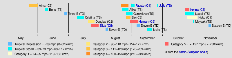
The 2002 Pacific hurricane season featured one of the most powerful hurricanes to ever strike the West Mexico coastline in the East Pacific hurricane database on record. Although Hurricane Alma developed on May 24, the season officially began on May 15, 2002 in the eastern Pacific, designated as the area east of 140°W, and on June 1, 2002 in the central Pacific, known as the region between the International Date Line and 140°W. The end of the season for both basins occurred on November 30, although Tropical Depression Sixteen-E dissipated on November 16.
The season produced nineteen tropical depressions, of which fifteen intensified into tropical storms, eight became hurricanes, and six became major hurricanes. While many tropical cyclones affected land during the season, Hurricane Kenna produced the most damage and loss of life. The third most powerful hurricane ever recorded in the East Pacific, Kenna reached maximum sustained winds of 165 mph (270 km/h), but weakened to a minimal Category 4 on the Saffir–Simpson Hurricane Wind Scale by the time the system moved ashore.
This timeline includes information that was not operationally released, meaning that data from post-storm reviews by the National Hurricane Center, such as a storm that was not operationally warned upon, has been included. This timeline documents tropical cyclone formations, strengthening, weakening, landfalls, extratropical transitions, and dissipations during the season.
Timeline of events
May

- May 1
- May 24
- 1800 UTC (5 a.m. PDT) – Tropical Depression One-E forms 485 miles (900 km) south-southeast of Manzanillo, Mexico.[2]
- May 26
- 1200 UTC (5 a.m. PDT) – Tropical Depression One-E strengthens into Tropical Storm Alma.[2]
- May 28
- 1800 UTC (5 a.m. PDT) – Tropical Storm Alma strengthens into a hurricane.[2]
- May 29
- 1800 UTC (5 a.m. PDT) – Hurricane Alma reaches category 2 strength.[2]
- May 30
- 0600 UTC (11 a.m. PDT) – Hurricane Alma becomes a major hurricane.[2]
- 1800 UTC (5 a.m. PDT) – Hurricane Alma weakens into a category 2 hurricane.[2]
- May 31
- 0600 UTC (11 p.m. PDT) – Hurricane Alma weakens into a category 1 hurricane.[2]
- 1200 UTC (5 a.m. PDT) – Hurricane Alma weakens into a tropical storm.[2]
June

- June 1
- The Central Pacific hurricane season officially begins.[1]
- 0600 UTC (11 p.m. PDT) – Tropical Storm Alma weakens into a tropical depression.[2]
- 1200 UTC (5 a.m. PDT) – Tropical Depression Alma dissipates.[2]
- June 8
- 1200 UTC (5 a.m. PDT) – Tropical Depression Two-E forms 150 miles (280 km) west-southwest of Acapulco, Mexico.[3]
- June 9
- 0000 UTC (5 p.m. PDT) – Tropical Depression Two-E strengthens into Tropical Storm Boris.[3]
- June 10
- 1800 UTC (5 a.m. PDT) – Tropical Storm Boris weakens into a tropical depression.[3]
- June 11
- 1800 UTC (5 a.m. PDT) – Tropical Depression Boris degenerates into a remnant low pressure area.[3]
- June 27
- 1200 UTC (5 a.m. PDT) – Tropical Depression Three-E forms 970 miles (1795 km) southwest of the southern tip of the Baja Peninsula.[4]
- June 29
- 0600 UTC (11 p.m. PDT) – Tropical Depression Three-E dissipates.[4]
July

- July 9
- 1200 UTC (5 a.m. PDT) – Tropical Depression Four-E forms 300 miles (555 km) south of Acapulco, Mexico.[5]
- July 12
- 0600 UTC (11 p.m. PDT) – Tropical Depression Four-E strengthens into Tropical Storm Cristina.[5]
- July 15
- 1200 UTC (5 a.m. PDT) – Tropical Storm Cristina weakens into a tropical depression.[5]
- July 17
- 0000 UTC (5 p.m. PDT) – Tropical Depression Cristina dissipates.[5]
- July 20
- 1200 UTC (5 a.m. PDT) – Tropical Depression Five-E forms 395 miles (730 km) south of Manzanillo, Mexico.[6]
- 1800 UTC (5 a.m. PDT) – Tropical Depression Five-E strengthens into Tropical Storm Douglas.[6]
- July 22
- 0000 UTC (5 p.m. PDT) – Tropical Storm Douglas becomes a hurricane.[6]
- 1200 UTC (5 a.m. PDT) – Hurricane Douglas strengthens to become a category 2 hurricane.[6]
- July 23
- 0600 UTC (11 p.m. PDT) – Tropical Depression Six-E forms 305 miles (565 km) south-southeast of Puerto Escondido, Mexico.[7]
- 1200 UTC (5 a.m. PDT) – Tropical Depression Six-E strengthens into Tropical Storm Elida.[7]
- 1800 UTC (5 a.m. PDT) – Hurricane Douglas weakens into a category 1 hurricane.[6]

- July 24
- 0600 UTC (11 p.m. PDT) – Tropical Storm Elida strengthens into a hurricane.[7]
- 1200 UTC (5 a.m. PDT) – Hurricane Elida strengthens into a major hurricane, skipping category 2 status.[7]
- 1800 UTC (5 a.m. PDT) – Hurricane Elida strengthens into a category 4 hurricane.[7]
- 1800 UTC (5 a.m. PDT) – Hurricane Douglas weakens into a tropical storm.[6]
- July 25
- 0600 UTC (11 p.m. PDT) – Hurricane Elida becomes the first category 5 hurricane of the season.[7]
- 1200 UTC (5 a.m. PDT) – Hurricane Elida weakens into a category 4 hurricane.[7]
- July 26
- 0000 UTC (5 p.m. PDT) – Hurricane Elida weakens into a category 3 hurricane.[7]
- 0000 UTC (5 p.m. PDT) – Tropical Storm Douglas weakens into a tropical depression.[6]
- 1800 UTC (5 a.m. PDT) – Hurricane Elida weakens into a category 2 hurricane.[7]
- 1800 UTC (5 a.m. PDT) – Tropical Depression Douglas degenerates into a remnant low pressure area.[6]
- July 27
- 0600 UTC (11 p.m. PDT) – Hurricane Elida weakens into a category 1 hurricane.[7]
- 1800 UTC (5 a.m. PDT) – Hurricane Elida weakens into a tropical storm.[7]
- July 29
- 1800 UTC (5 a.m. PDT) – Tropical Storm Elida weakens into a tropical depression.[7]
- July 30
- 1800 UTC (5 a.m. PDT) – Tropical Depression Elida weakens into a remnant low pressure area.[7]
August

- August 6
- 0000 UTC (5 p.m. PDT) – Tropical Depression Seven-E forms 785 miles (1455 km) southwest of the southern tip of the Baja Peninsula.[8]
- August 8
- 0600 UTC (11 p.m. PDT) – Tropical Depression Seven-E dissipates.[8]
- August 21
- 1200 UTC (5 a.m. PDT) – Tropical Depression Eight-E forms 400 miles (740 km) south-southwest of Manzanillo, Mexico.[9]
- August 22
- 0000 UTC (5 p.m. August 21 PDT) – Tropical Depression Eight-E strengthens into Tropical Storm Fausto.[9]
- 1800 UTC (5 a.m. PDT) – Tropical Storm Fausto becomes a hurricane.[9]
- 1800 UTC (2 a.m. HST) – Tropical Depression One-C forms over 1000 miles (1850 km) south of Hawaii.[10]

- August 23
- 1200 UTC (5 a.m. PDT) – Hurricane Fausto becomes a category 2 hurricane.[9]
- 1800 UTC (5 a.m. PDT) – Hurricane Fausto becomes a major hurricane.[9]
- August 24
- 0600 UTC (11 p.m. PDT) – Hurricane Fausto becomes a category 4 hurricane.[9]
- August 25
- 0000 UTC (2 p.m. August 24 HST) – Tropical Depression One-C strengthens into a tropical storm and is named Alika.[10]
- 0600 UTC (11 p.m. PDT) – Hurricane Fausto weakens into a category 3 hurricane.[9]
- 1200 UTC (5 a.m. PDT) – Hurricane Fausto weakens into a category 2 hurricane.[9]

- August 26
- 0000 UTC (5 p.m. PDT) – Tropical Depression Nine-E forms 500 miles (925 km) south of the Baja Peninsula.[11]
- 0600 UTC (11 p.m. PDT) – Hurricane Fausto weakens into a category 1 hurricane.[9]
- 1200 UTC (5 a.m. PDT) – Hurricane Fausto weakens into a tropical storm.[9]
- August 27
- 0000 UTC (2 p.m. August 26 HST) – Tropical Depression Two-C forms about 1000 miles (1850 km) southwest of the Hawaiian Islands.[12]
- 0000 UTC (5 p.m. PDT) – Tropical Depression Nine-E strengthens into a tropical storm and is named Genevieve.[11]
- 0000 UTC (2 p.m. August 26 HST) – Tropical Storm Alika weakens into a tropical depression.[10]
- 0600 UTC (8 p.m. HST) – Tropical Depression Two-C strengthens into a tropical storm and is named Ele.[12]

- August 28
- 0000 UTC (2 p.m. August 27 HST) – Tropical Storm Ele strengthens into a hurricane.[12]
- 0000 UTC (5 p.m. PDT) – Tropical Storm Fausto weakens into a tropical depression as it crosses into the Central Pacific.[9]
- 0600 UTC (8 p.m. August 27 HST) – Tropical Depression Alika dissipates.[10]
- 1200 UTC (5 a.m. PDT) – Tropical Depression Fausto degenerates into a low.[9]
- August 29
- 0600 UTC (8 p.m. August 28 HST) – Hurricane Ele strengthens into a category 2 hurricane.[12]
- 1800 UTC (2 a.m. HST) – Hurricane Ele strengthens into a major hurricane.[12]
- August 30
- 0000 UTC (2 p.m. August 29 HST) – Hurricane Ele moves out of the Central Pacific and into the West Pacific where the JMA takes up warning responsibility.[12]
- 0600 UTC (11 p.m. PDT) – Tropical Depression Ten-E forms 340 miles (630 km) south-southwest of Manzanillo, Mexico.[13]
- 1200 TC (5 a.m. PDT) – Tropical Depression Ten-E strengthens into a tropical storm and is named Hernan.[13]
- 1200 UTC (5 a.m. PDT) – Tropical Storm Genevieve weakens into a tropical depression.[11]
- 1800 UTC (5 a.m. PDT) – Tropical Depression Fausto regenerates about 430 miles (795 km) north of the Hawaiian Islands.[9]
- August 31
- 0600 UTC (11 p.m. PDT) – Tropical Storm Hernan becomes a hurricane.[13]
- 1200 UTC (5 a.m. PDT) – Hurricane Hernan strengthens into a category 2 hurricane.[13]
- 1800 UTC (5 a.m. PDT) – Hurricane Hernan strengthens into a major hurricane.[13]
September
- September 1
- 0000 UTC (5 p.m. PDT) – Hurricane Hernan strengthens into a category 4 hurricane.[13]
- 0600 UTC (11 p.m. PDT) – Tropical Depression Genevieve dissipates.[11]
- 1200 UTC (5 a.m. PDT) – Hurricane Hernan strengthens into a category 5 hurricane.[13]
- 1800 UTC (5 a.m. PDT) – Tropical Depression Fausto re-strengthens into a tropical storm.[9]

- September 2
- 0000 UTC (5 p.m. PDT) – Hurricane Hernan weakens into a category 4 hurricane.[13]
- 1200 UTC (5 a.m. PDT) – Hurricane Hernan weakens into a category 3 hurricane.[13]
- September 3
- 0000 UTC (5 p.m. PDT) – Hurricane Hernan weakens into a category 2 hurricane.[13]
- 0600 UTC (11 p.m. PDT) – Tropical Storm Fausto is absorbed by an extratropical low.[9]
- September 4
- 0000 UTC (5 p.m. PDT) – Hurricane Hernan weakens into a category 1 hurricane.[13]
- 1200 UTC (5 a.m. PDT) – Hurricane Hernan weakens into a tropical storm.[13]
- September 5
- 1200 UTC (5 a.m. PDT) – Tropical Storm Hernan weakens into a tropical depression.[13]
- September 6
- 0000 UTC (5 p.m. PDT) – Tropical Depression Eleven-E forms 120 miles (220 km) southwest of Cabo Corrientes, Mexico.[14]
- 1800 UTC (5 a.m. PDT) – Tropical Depression Hernan weakens into a remnant low pressure area.[13]
- September 8
- 1800 UTC (5 a.m. PDT) – Tropical Depression Eleven-E weakens into a remnant low pressure area.[14]
- September 15
- 0600 UTC (11 p.m. PDT) – Tropical Depression Twelve-E forms 270 miles (500 km) south of Manzanillo, Mexico.[15]

- September 16
- 0000 UTC (5 p.m. PDT) – Tropical Depression Twelve-E strengthens into a tropical storm and is named Iselle.[15]
- September 19
- 1800 UTC (5 a.m. PDT) – Tropical Storm Iselle weakens into a tropical depression.[15]
- September 20
- 0600 UTC (11 p.m. PDT) – Tropical Depression Iselle weakens into a remnant low pressure area.[15]

- September 25
- 0000 UTC (5 p.m. PDT) – Tropical Depression Thirteen-E forms 175 miles (325 km) southwest of Acapulco, Mexico.[16]
- 1200 UTC (5 a.m. PDT) – Tropical Depression Thirteen-E strengthens into a tropical storm and is named Julio.[16]
- September 26
- 0000 UTC (5 p.m. PDT) – Tropical Storm Julio makes landfall west-northwest of Lazaro Cardenas, Mexico with winds of 45 mph (70 km/h).[16]
October
- October 22
- 0000 UTC (5 p.m. PDT) – Tropical Depression Fourteen-E forms 325 miles (600 km) south of Acapulco, Mexico.[17]
- 0600 UTC (11 p.m. October 21 PDT) – Tropical Depression Fourteen-E strengthens into a tropical storm and is named Kenna.[17]
- 1800 UTC (5 a.m. PDT) – Tropical Depression Fifteen-E forms in the western portion of the Eastern Pacific.[18]
- October 23
- 0600 UTC (11 p.m. October 22 PDT) – Tropical Depression Fifteen-E strengthens into a tropical storm and is named Lowell.[18]
- 1800 UTC (5 a.m. PDT) – Tropical Storm Kenna strengthens into a hurricane.[17]

- October 24
- 0000 UTC (5 p.m. October 23 PDT) – Hurricane Kenna strengthens into a category 2 hurricane.[17]
- 0600 UTC (11 p.m. October 23 PDT) – Hurricane Kenna strengthens into a major hurricane.[17]
- 1200 UTC (5 a.m. PDT) – Hurricane Kenna strengthens into a category 4 hurricane.[17]
- 1800 UTC (5 a.m. PDT) – Hurricane Kenna strengthens into a category 5 hurricane.[17]
- 1800 UTC (11 a.m. PDT) – Tropical Storm Lowell weakens into a tropical depression.[18]
- 1800 UTC (2 a.m. PDT) – Tropical Depression Three-C forms south of the Hawaiian Islands.[19]

- October 25
- 0000 UTC (5 p.m. October 24 PDT) – Hurricane Kenna becomes the strongest of the season with winds of 165 mph (265 km/h) and a pressure of 913 mbar (26.96 inHg).[17]
- 1200 UTC (5 a.m. PDT) – Hurricane Kenna weakens into a category 4 hurricane.[17]
- 1630 UTC - Hurricane Kenna makes landfall near San Blas, Mexico with winds of 140 mph (225 km/h), only the 1959 Mexican hurricane and Hurricane Madeline of 1976 are stronger at landfall.[17]
- 1800 UTC (5 a.m. PDT) – Hurricane Kenna weakens into a category 3 hurricane.[17]
- October 26
- 0000 UTC (2 p.m. October 25 HST) – Tropical Depression Three-C strengthens into a tropical storm and is named Huko.[19]
- 0000 UTC (5 p.m. PDT) – Hurricane Kenna rapidly weakens into a tropical storm over Mexico.[17]
- 0600 UTC (11 p.m. PDT) – Tropical Storm Kenna dissipates.[17]
- October 27
- 1800 UTC (5 a.m. PDT) – Tropical Depression Lowell re-strengthens into a tropical storm.[18]
- October 28
- 1800 UTC (5 a.m. PDT) – Tropical Storm Huko strengthens into a hurricane.[19]
- October 29
- 1200 UTC (5 a.m. PDT) – Tropical Storm Lowell again weakens into a tropical depression.[18]
- October 30
- 0000 UTC (2 p.m. October 29 HST) – Hurricane Huko weakens into a tropical storm.[19]

- October 31
- 0000 UTC (5 p.m. PDT) – Tropical Depression Lowell dissipates.[18]
- 0600 UTC (11 p.m. October 30 HST) – Tropical Storm Huko again strengthens into a hurricane.[19]
November
- November 3
- 0600 UTC (8 p.m. November 2 HST) – Hurricane Huko moves out of the Central Pacific Hurricane Center's Area of Responsibility.[19]
- November 14
- 0000 UTC (5 p.m. PDT) – Tropical Depression Sixteen-E forms 370 miles (685 km) south of Acapulco, Mexico.[20]
- November 16
- 0600 UTC (11 p.m. PDT) – Tropical Depression Sixteen-E weakens into a remnant low pressure area.[20]
- November 30
- The Eastern and Central Pacific hurricane seasons officially ends.[1]
See also
References
- ^ a b c Atlantic Oceanographic and Meteorological Laboratory, Hurricane Research Division. "Frequently Asked Questions: When is hurricane season?". National Oceanic and Atmospheric Administration. Retrieved 2008-10-22.
- ^ a b c d e f g h i j National Hurricane Center (2002). "Hurricane Alma Tropical Cyclone Report". National Hurricane Center. Retrieved 2008-10-24.
- ^ a b c d National Hurricane Center (2002). "Tropical Storm Boris Tropical Cyclone Report". National Hurricane Center. Retrieved 2008-10-24.
- ^ a b National Hurricane Center (2002). "TD 3-E Tropical Cyclone Report". National Hurricane Center. Retrieved 2008-10-24. [dead link]
- ^ a b c d National Hurricane Center (2002). "Tropical Storm Cristina Tropical Cyclone Report". National Hurricane Center. Retrieved 2008-10-24.
- ^ a b c d e f g h National Hurricane Center (2002). "Hurricane Douglas Tropical Cyclone Report". National Hurricane Center. Retrieved 2008-10-24.
- ^ a b c d e f g h i j k l m National Hurricane Center (2002). "Hurricane Elida Tropical Cyclone Report". National Hurricane Center. Retrieved 2008-10-24.
- ^ a b National Hurricane Center (2002). "TD 7-E Tropical Cyclone Report". National Hurricane Center. Retrieved 2008-10-24.
- ^ a b c d e f g h i j k l m n o National Hurricane Center (2002). "Hurricane Fausto Tropical Cyclone Report". National Hurricane Center. Retrieved 2008-10-24.
- ^ a b c d "Tropical Cyclone Report:Tropical Storm Alika". Central Pacific Hurricane Center. May 2003. Retrieved 2009-04-09.
- ^ a b c d Avila, Lixion A. (October 12, 2002). "Tropical Cyclone Report:Tropical Storm Genevieve". National Hurricane Center. Retrieved 2009-04-09.
- ^ a b c d e f "Tropical Cyclone Reports:Hurricane Ele". Central Pacific Hurricane Center. May 2003. Retrieved 2009-04-09.
- ^ a b c d e f g h i j k l m n Lawrence, Miles B. (December 12, 2002). "Tropical Cyclone Report:Hurricane Hernan". National Hurricane Center. Retrieved 2009-04-09.
- ^ a b Pasch, Richard J. (January 13, 2003). "Tropical Cyclone Report:Tropical Depression Eleven-E". National Hurricane Center. Retrieved 2009-04-09.
- ^ a b c d Stewart, Stacy R. (November 10, 2002). "Tropical Cyclone Report:Tropical Storm Iselle". National Hurricane Center. Retrieved 2009-04-09.
- ^ a b c d e Beven, Jack (December 11, 2002). "Tropical Cyclone Report:Tropical Storm Julio". National Hurricane Center. Retrieved 2009-04-09.
- ^ a b c d e f g h i j k l m Franklin, James L. (December 26, 2002). "Tropical Cyclone Report:Hurricane Kenna". National Hurricane Center. Retrieved 2009-04-09.
- ^ a b c d e f Avila, Lixion A. (December 27, 2002). "Tropical Cyclone Report: Tropical Storm Lowell". National Hurricane Center. Retrieved 2009-04-09.
- ^ a b c d e f "Tropical Cyclone Report:Hurricane Huko". Central Pacific Hurricane Center. May 2003. Retrieved 2009-04-09.
- ^ a b Lawrence, Miles B. (December 4, 2002). "Tropical Cyclone Report:Tropical Depression Sixteen-E". National Hurricane Center. Retrieved 2009-04-09.
Tropical cyclones of the 2002 Pacific hurricane season | ||
|---|---|---|
| ||