Camino Real de Tierra Adentro: Difference between revisions
m v1.43b - WP:WCW project (Unicode control characters) |
ILoveCaracas (talk | contribs) |
||
| Line 75: | Line 75: | ||
In 1848 with the [[Treaty of Guadalupe Hidalgo]], the war was officially ended with the requisition that Mexico cede most of its northern territory including what are now the states of [[New Mexico]], [[Colorado]], [[Arizona]], and [[California]]. The Camino Real de Tierra Adentro was divided forever between two countries, and over time their stories lasted while many others were lost; however, its cultural legacy is still tangible in our days. |
In 1848 with the [[Treaty of Guadalupe Hidalgo]], the war was officially ended with the requisition that Mexico cede most of its northern territory including what are now the states of [[New Mexico]], [[Colorado]], [[Arizona]], and [[California]]. The Camino Real de Tierra Adentro was divided forever between two countries, and over time their stories lasted while many others were lost; however, its cultural legacy is still tangible in our days. |
||
== Uses of the name and controversies == |
|||
[[File:Placaloscuatillosunesco.JPG|thumb|left|Plaque commemorating inscrpition of the Camino Real de Tierra Adentro into the UNESCO World Heritage list.]] |
|||
[[File:El Camino Real de Tierra Adentro National Historic Trail by Samat Jain.jpg|thumb|264x264px|The section of the road that runs through US territory, a total of 646 kilometers, was declared "National Historic Trail" in October of 2000.]] |
|||
The name lends itself to discussion or confusion, since during the [[Viceroyalty of New Spain]] was called "Camino Real" all roads passable in cart, which existed in a significant number throughout the viceroyalty. In the same way, it was called "Tierra Adentro" to the unexplored territories, particularly towards the north of the viceroyalty, which is why it was first called to [[Querétaro City]], and later to [[Saltillo]] "La Puerta de Tierra Adentro" ("The Door of Tierra Adentro". For this reason, historically there were several "Caminos Reales de Tierra Adentro". In addition to the road to Santa Fe, another important road is the one that led to [[Texas]]. The '''"Camino Real de Tierra Adentro"''', which led to [[New Mexico]], apparently adopted its name recently in [[United States]] to have legal protection, regardless of the fact that, when making legal use of it, the other Caminos Reales, such as Texas, were demerited, so that the use of such a name for the latter is not legally permitted (at least in the [[United States]]), although historically this was called. |
|||
== World Heritage Site == |
|||
[[File:Placaloscuatillosunesco.JPG|thumb|264x264px|Plate awarded by [[UNESCO]] to the recognized sites of the section of the road that runs through Mexican territory.]] |
|||
The section of the road that runs through Mexican territory was inscribed in the [[World Heritage Site|World Heritage List]] in November 2001, under the cultural criteria (i) and (ii), which refer to: i) Represent a masterpiece of the creative genius of man; and, ii) Be the manifestation of a considerable exchange of influences, during a specific period or in a specific cultural area, in the development of architecture or technology, monumental arts, urban planning or landscape design. Finally, on August 1, 2010, the United Nations World Heritage Committee for Education, Science and Culture ([[UNESCO]]) added this tour as [[World Heritage]], together with another 24 new sites from various countries of the world. |
|||
In 2010, UNESCO included a portion of the Camino Real de Tierra Adentro as cultural heritage of humanity, under the criteria (ii): ''"to witness an important exchange of human values over a period of time or within of a cultural area of the world, in the development of architecture or technology, monumental arts, urbanism or landscape design"'' and (iv): ''"offer an eminent example of a type of building, architectural, technological or landscape , that illustrates a significant stage of human history''". The designation thus, gave as a core zone to 3,102 hectares, with a buffer zone of 268,057 hectares; distributed among multiple sites. |
|||
There are 60 places that were included in the list as [[World Heritage]], 5 of which had already been recognized under their own name in the past ([[Historic center of Mexico City|Mexico City]], [[Querétaro City]], [[Guanajuato City]], [[San Miguel de Allende]] and [[Zacatecas]]).<ref name = "UNESCO Heritage">{{web cite| url = http://whc.unesco.org/es/list/1351/documents/|title = List of sites of the Camino Real de Tierra Adentro | year = 2010 | author = UNESCO World Heritage Convention}}</ref> It should be mentioned that the original historical route should not be confused with the one named by [[Unesco]], since it has excluded sites of great importance for the route such as the [[Chihuahua City]] or the famous [[Hacienda de San Diego del Jaral de Berrio|Hacienda of San Diego del Jaral de Berrio]] in the [[Guanajuato|State of Guanajuato]],<ref> [http://vamonosalbable.blogspot.mx/search/label/Unesco http://vamonosalbable.blogspot.mx/search/label/Unesco]<br /> |
|||
</ref> a key point for the route, to cite 2 samples. For this reason, a possible expansion of the denomination has been proposed in the future; currently the [[Instituto Nacional de Antropología e Historia]] performs the search to find original stretches of the road in context, such as bridges, pavements, haciendas, etc. |
|||
=== Declared sites === |
|||
; Mexico City and State of Mexico |
|||
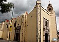
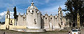
[[File:SFJavierTepozotlanFacade.JPG|upright|right|thumb|[[Museo Nacional del Virreinato|Old College]] of [[Templo de San Francisco Javier (Tepotzotlán)|San Francisco Javier]] in [[Tepotzotlán]].]] |
|||
1351-000: [[Historic center of Mexico City]].<br/> |
|||
1351-001: [[Museo Nacional del Virreinato|Old College]] of [[Templo de San Francisco Javier (Tepotzotlán)|San Francisco Javier]] in [[Tepotzotlán]].<br/> |
|||
1351-002: [[Aculco|Aculco town]].<br/> |
|||
1351-003: [[Puente de Atongo|Bridge of Atongo]].<br/> |
|||
1351-004: Section of the Camino Real between [[Aculco]] and [[San Juan del Río Municipality, Querétaro|San Juan del Río]].<br/> |
|||
[[File:Zocalo Panorama seen from rooftop restaurant.jpg|thumb|center|800px|Panorama of [[Zócalo|Plaza del Zócalo]] with [[National Palace (Mexico)|Palacio Nacional]] at front and flanked by the [[Mexico City Metropolitan Cathedral|Metropolitan Cathedral]], the [[Former City Hall, Mexico City|Former City Hall]] and its twin building.]] |
|||
; State of Hidalgo |
|||
1351-005: [[Templo and exconvento de San Francisco, Tepeji del Río|Former convent of San Francisco]] in [[Tepeji del Río de Ocampo]] and bridge.<br/> |
|||
1351-006: Section of the Camino Real between the [[puente de La Colmena|bridge of La Colmena]] and the [[Hacienda de La Cañada|Hacienda of La Cañada]].<br/> |
|||
<center> <gallery> |
|||
Saint Francis of Assisi Church, Tepeji del Rio, Hidalgo State, Mexico.jpg | [[Templo and exconvento de San Francisco, Tepeji del Río|Former convent of San Francisco]] in [[Tepeji del Río de Ocampo]] |
|||
File:Puente Camino Real..JPG|Bridge of La Colmena. |
|||
</gallery> </center> |
|||
; State of Querétaro |
|||
1351-007: [[Historic center of San Juan del Río|Historic center]] of [[San Juan del Río]].<br/> |
|||
1351-008: [[Hacienda de Chichimequillas|Hacienda of Chichimequillas]].<br/> |
|||
1351-009: [[Hacienda Buenavista, Querétaro|Chapel of the hacienda of Buenavista]]. <br/> |
|||
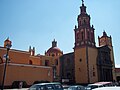
1351-010: [[Historic center of Querétaro City|Historic center]] of [[Querétaro City]]. <br/> |
|||
<center> <gallery> |
|||
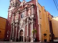
Catedral de Querétaro.jpg|[[Querétaro Cathedral|Querétaro City Cathedral]]. |
|||
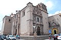
AgustinChurchQRO03.JPG|[[Templo y exconvento de San Agustín de Querétaro|Temple and ex-convent of San Agustín of Querétaro]]. |
|||
Iglesia de San Francisco, Queretaro.JPG|[[Templo y exconvento de San Francisco de Asís, Querétaro City|Temple and ex-convent of Saint Francis of Assisi of Querétaro]]. |
|||
08013-Casa de la Corregidora.jpg|[[Casa de la Corregidora|[[Casa de la Corregidora, Querétaro City|Casa de la Corregidora]] in Querétaro City. |
|||
Acueductos Ciudad de Querétaro México.jpg|[[Querétaro City Aqueduct]]. |
|||
Templo Parroquial.jpg|[[Capilla de Nuestra señora de Guadalupe, San Juan del Río.|Chapel of Our Lady of Guadalupe]] in San Juan del Río. |
|||
</gallery></center> |
|||
; State of Guanajuato |
|||
1351-011: [[Puente de El Fraile|Bridge of El Fraile]].<br/> |
|||
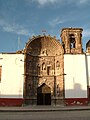
1351-012: [[Antiguo Real Hospital de San Juan de Dios|Former Royal Hospital of San Juan de Dios]] in [[San Miguel de Allende]]. <br/> |
|||
1351-013: [[Bridge of San Rafael, Guanajuato City| Bridge of San Rafael]] in Guanajuato City. <br/> |
|||
1351-014: [[Puente La Quemada|Bridge La Quemada]].<br/> |
|||
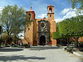
1351-015: [[San Miguel de Allende]] and [[Sanctuary of Atotonilco|Sanctuary of Jesús Nazareno de Atotonilco]]. <br/> |
|||
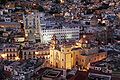
1351-016: [[Historic center of Guanajuato City|Historic center]] of Guanajuato City and its adjacent mines.<br/> |
|||
<center> <gallery> |
|||
Iglesia del Hospital de San Juan de Dios de San Miguel de Allende, Guanajuato.JPG|[[Antiguo Real Hospital de San Juan de Dios|Former Royal Hospital of San Juan de Dios]]. |
|||
Senora de la Salud.jpg|[[Iglesia de Nuestra Señora de la Salud, San Miguel Allende|Church of Nuestra Señora de la Salud]] in San Miguel Allende. |
|||
Parroquia 14.JPG|[[Parroquia de San Miguel Arcángel|Parish of San Miguel Arcángel]] in San Miguel Allende. |
|||
Sanctuary of Jesús Nazareno.JPG | Sanctuary of Jesús Nazareno de Atotonilco. |
|||
Panorâmica do Santuário de Atotonilco.jpg|[[Sanctuary of Atotonilco|Sanctuary of Jesús Nazareno de Atotonilco]]. |
|||
Guanaguato at night.jpg|Guanaguato City panorama. |
|||
Guana5.JPG|[[Teatro Juárez, Guanajuato City|Juárez Theatre]] in Guanajuato City. |
|||
</gallery> </center> |
|||
==List of World Heritage locations== |
==List of World Heritage locations== |
||
Revision as of 01:48, 10 January 2018
| Camino Real de Tierra Adentro | |
|---|---|
 Map of El Camino Real de Tierra Adentro | |
| Location | Mexico and the United States |
| Governing body | Instituto Nacional de Antropología e Historia (Mexico) National Park Service, Bureau of Land Management (United States) |
| Website | El Camino Real de Tierra Adentro National Historic Trail |
The Camino Real de Tierra Adentro (Spanish for "Royal Road of the Interior Land") was a 2560 kilometer (1,600 mile) long trade route between Mexico City and San Juan Pueblo, New Mexico, from 1598 to 1882.[1]
In 2010, 55 sites and 5 existing World Heritage Sites along the Mexican section of the route became an entry on the Unesco World Heritage List.[2] Those sites include historic cities, towns, bridges, haciendas and other monuments along the 1,400km route between the Historic Center of Mexico City (independent World Heritage Site) and the town of Valle de Allende, Chihuahua.
The 404 mile (646 kilometer) section of the route within the United States was proclaimed as a part of the National Historic Trail system on 13 October 2000. El Camino Real de Tierra Adentro National Historic Trail is overseen by both the National Park Service and the U.S. Bureau of Land Management with aid from El Camino Real de Tierra Adentro Trail Assoc. also known as CARTA. A portion of the trail near San Acacia, New Mexico was listed on the National Register of Historic Places in 2014.[3]
History


Before the arrival of the Spaniards, nomadic tribes lived by hunting and fishing. Then agriculture took root. Over time, "great civilizations" emerged and flourished. And long before the Europeans arrived, they already had established the trade network that would later become the Camino Real de Tierra Adentro. In those years, trade connected the peoples of the valley of Mexico with those of the north through the exchange of products such as turquoise, obsidian, salt and feathers, so that by the year 1000, trade spread from Mesoamerica to Rocky Mountains.[4]
Once the great Tenochtitlan was subdued, the conquistadors began a series of expeditions with the purpose of expanding their domains and obtaining greater wealth for the Spanish Crown. At first they followed the trails with the "fragile footprints" of the natives who exchanged goods between the north and the south.
Researchers Enrique Lamadrid, Jack Loeffer and Tomás Saldaña tell the story of the Camino Real as the oldest in North America:
"The royal roads were the main transport routes for communication, cultural change and commerce.) The viceroyal army, organized in light cavalry flying companies, protected travelers, livestock and merchandise"
In April 1598 -the investigators point out- "an advanced group of soldiers is lost in the desert south of Paso del Norte, seeking the best route to the Rio Grande. A captive Indian named Mompil drew in the sand a map of the only safe passage, which would soon be part of the Camino Real de Tierra Adentro". It is in this year, when this group, mainly led by the New-Spanish Juan de Oñate,[5] consolidated and extended the journey to what is now Santa Fe, capital of the then province of New Mexico, at that time, part of the New Spain.
It should be noted that there were four main roads, or main routes, of Camino Real, which linked Mexico City with Acapulco, Veracruz, Audiencia (Guatemala) and Santa Fe: "They formed a quadruple route full of walkers, carts and mule trains". From these is derived the Camino Real de Tierra Adentro, which was the one that went to the north.
The Camino Real de Tierra Adentro followed a path marked by the terrain: "The volcanic activity and an inclement climate worked a land rich in deposits of silver, copper, gold, opals, turquoises and salt. The displacements of the tectonic plates opened in the center of New Mexico a crack more than a kilometer and a half deep, the second longest in the world. The melting waters that flowed into the valley formed the Rio Grande and it filled the deep gap with sediment".
Initially when the Spanish Crown decided not to abandon the province of New Mexico, ruinous in all respects, but to maintain it so as not to leave the Indigenous already Christianized, the Viceroyalty of New Spain organized a system to supply the missions, presidios and nortern ranchos. It is in the so-called conducta, that they decide to organize themselves in wagon caravans that depart every three years from Mexico City to the border. It began a long and difficult journey of six months, including 2–3 weeks of rest throughout the trip. Many were the uncertainties that travelers faced. The floods of the rivers could force weeks of waiting on the banks until they could wade through. At the other extreme appeared prolonged droughts, which made men and animals suffer. The most feared was the crossing of the so-called Jornada del Muerto, beyond El Paso del Norte: a hundred kilometers without water to stock up. The greatest danger was that of assaults. There were specialized bands that from the current states of Mexico to the state of Querétaro lurked the caravan (full of valuable articles). And, above all, from the southern Zacatecas, the greatest threat was the attacks of Natives Chichimecas, more frequent as it progressed towards the north. Their main objective was horses, sometimes even women and children. The troops of the presidios made relays to endow the convoy of additional protection, and when the caravan entered the most committed areas, to spend the night the cars formed a circle with the people and animals inside.


The route was actively used as a commercial route for 300 years, from the middle of the 16th century to the 19th century, mainly for the transport of silver extracted from mines. For this reason, the road was improving, and over time the risks became smaller as hospitals and haciendas emerged.
During the 18th century the sites along the Camino Real increased significantly. The villa of San Felipe el Real (today city of Chihuahua) surrounded by its mines became a commercial center and important financial area between Durango and Santa Fe, this area would be called "the Chihuahua Trail". The villa of San Felipe Neri de Alburquerque was in turn founded in 1706 (today Albuquerque, New Mexico, the "r" is lost in the 19th century) and soon it became an important terminal along the "Chihuahua Trail". The Villa de Alburquerque was very important because of its defensive position on the Camino Real which gave it the chance to grow as a center of commercial exchange during the 18th century. The state of New Mexico traded mainly with cattle, wool, textiles, animal skins, salt, and nuts. This exchange occurred mainly with the mining cities of Chihuahua, Santa Bárbara and Parral. For the year of 1765 the population of the Paso del Norte was 2,635 inhabitants, which created that it was the largest urban center on the northern border of New Spain. El Paso became an important center of agriculture and rancheria and was known for its wines, brandy, vinegar and raisins.
In the 18th century the Spanish Crown authorized the celebration of the fairs, however they existed since the beginning of the Colony. Some of the most important fairs along the Camino Real included the Fair of San Juan de los Lagos in Jalisco, the Fair of Saltillo, and the Fair of Chihuahua, which was of great importance to New Mexico merchants. The Fair of the town of Taos was also an important annual event where the comanches and the utes exchanged weapons, ammunition, horses, agricultural products, furs, and meats with the New-Spanish. Spain at the same time maintained a monopoly with the products of its northern provinces, thus it was not allowed to trade with the French colony in Louisiana.
For the second half of the 18th century, the northern frontier of New Spain represented a fundamental interest for the Spanish Empire and its reformist policy, with the aim of ensuring Spanish sovereignty over such important territories, highly coveted geopolitically by other European powers:[6] a conciliatory policy was pertinent, above all because of the dangerous presence in the area of English and French, and a reconsideration of the role assigned to the Natives, since not only was it wanted not to hostile the Spaniards, become and be linked to economic processes, but also participate in the defense of the border.[6]
Thus, the captain Nicolás de Lafora (assigned by the then marquis of Rubí) gives a description of the frontier of New Spain in his "Viaje a los presidios internos de la América septentrional" and that is the product of the expedition that took place between 1766 and 1768. This expedition was only part of a larger commission on the defensive issues and military reorganization entrusted by the Spanish Empire to the Marquis of Rubí, to find out the bad tactical placement of the presidios, inspected the troops, recognized the regulations and proposed what was convenient for a better government and defensive state. The Marquis of Rubí thus militarily inspected the prisons in the internal provinces and proposed a line of presidios in the New Spain border in 1766 which was raised from the Gulf of Mexico to protect itself from the utes, apaches, comanches, and navajos.[7] Don José de Gálvez, special commissioner to New Spain for Charles III, promoted a "Comandancia General de las Provincias Internas" to the northern New Spain and recognized that a long war with the natives would be impossible due to lack of resources. On the contrary, he himself incited the establishment of peace and a greater commercial increase in 1779. In 1786 the nephew of José de Gálvez, Bernardo de Gálvez, viceroy of New Spain published his "Instructions" which included three strategies for deal with the Natives: continue the military pressure, the formation of alliances, and create a state of dependence on the part of the Natives, who had entered into peace treaties with the Spanish Crown.
During the last decade of 18th century peace was achieved between the Spaniards and the Apache tribes as a result of the aforementioned administrative and strategic changes. As a result, the commercial exchange of several products and of several regions of New Spain (land products), European products of the Spanish fleet and also those that came from the Manila galleon that arrived annually at Acapulco. As an example, for this time, the most typical products sold by the merchants of the city of Parral in the northern of the road, included: platoncillos of Michoacán, jarrillos of Cuautitlán of the State of Mexico, majolica of the State of Puebla, porcelain junks of China, and mud products of Guadalajara.
The 19th century brought many changes for both Mexico and its northern border. In 1821 after 11 years of struggle, Mexico became independent from Spain. The Camino Real maintained an important role in this period, since the travelers maintained the communication about the events that took place in the center of the country in the towns and villages in the internal provinces. During the Independence the Camino Real was used by both forces, rebels and royal forces. An example of this is that after the rebellion started by the liberator Miguel Hidalgo y Costilla, he used the road to go to the city of Chihuahua where he was captured and executed

During and after independence, the government was unstable and the struggle continued, the resources sent to the northern provinces were continuously reduced, which led to the creation of alternate routes. For 1807, American merchants and other border military like Zebulon Pike tried to find trails to give to New Mexico and Chihuahua. Zebulon Pike was captured on 26 February 1807 by the Spanish authorities in northern New Mexico, who sent him on the Camino Real to the city of Chihuahua. While Zebulon Pike was in this city, he had access to several maps of Mexico and learned of the discontent with Spanish domination.
Between 1821 and 1822, after the end of the war for the Independence of Mexico, it begins to consolidate as a route the Santa Fe Trail that connected Missouri (US territory) and Santa Fe (Mexican territory). At first, US merchants were imprisoned for infiltrating contraband into Mexican territory, however the economic crisis in northern Mexico, gave rise to more and more acceptance of this type of trade. In fact, the Santa Fe Trail (Sendero de Santa Fe) increased trade for local products (such as cotton) and manufactured products from New Mexico, so Mexicans in this area looked favorably on this new trade route, in turn that they did not stop visiting the cities of the south. For 1827, there was already a lucrative and commercial connection between Missouri, New Mexico and Chihuahua.
In 1846, the dispute over the Texas-Mexico border with the United States gave rise to the subsequent US invasion by US military forces and the Mexican–American War began. One of these forces was commanded by the general Stephen Kearny, who traveled by the Santa Fe Trail to seize the capital of New Mexico. Another of the forces commanded by Colonel Alexander William Doniphan defeated a small group of Mexican contingents on the Camino Real, in the Los Brazitos area the south of what is now Las Cruces, New Mexico which was described in the diary of Susan Shelby Magoffin the wife of a merchant. As a result, Doniphan's American forces captured El Paso del Norte and later the city of Chihuahua. During 1846 - 1847, the Camino Real de Tierra Adentro became a path of continuous use, with American forces using it to travel into the interior of Mexico . On their journey, many American travelers kept journals and wrote to their homes about what they saw as they left. One of the soldiers provided an estimate of the population of several cities along the Camino. These included, Algodones with 1000 inhabitants, Bernalillo with 500, Sandía Pueblo of 300 to 400, Albuquerque without an estimated number but extended by seven or eight miles along the Rio Grande, rancho de los Placeres with 200 or 300, Tomé with 2,000, and Socorro was described as a "considerable city", Paso del Norte with 5,000 to 6,000, and the Carrizal with 400 inhabitants. The soldiers even kept notes of the products, prices, and animals that were on their journeys.
In 1848 with the Treaty of Guadalupe Hidalgo, the war was officially ended with the requisition that Mexico cede most of its northern territory including what are now the states of New Mexico, Colorado, Arizona, and California. The Camino Real de Tierra Adentro was divided forever between two countries, and over time their stories lasted while many others were lost; however, its cultural legacy is still tangible in our days.
Uses of the name and controversies

The name lends itself to discussion or confusion, since during the Viceroyalty of New Spain was called "Camino Real" all roads passable in cart, which existed in a significant number throughout the viceroyalty. In the same way, it was called "Tierra Adentro" to the unexplored territories, particularly towards the north of the viceroyalty, which is why it was first called to Querétaro City, and later to Saltillo "La Puerta de Tierra Adentro" ("The Door of Tierra Adentro". For this reason, historically there were several "Caminos Reales de Tierra Adentro". In addition to the road to Santa Fe, another important road is the one that led to Texas. The "Camino Real de Tierra Adentro", which led to New Mexico, apparently adopted its name recently in United States to have legal protection, regardless of the fact that, when making legal use of it, the other Caminos Reales, such as Texas, were demerited, so that the use of such a name for the latter is not legally permitted (at least in the United States), although historically this was called.
World Heritage Site

The section of the road that runs through Mexican territory was inscribed in the World Heritage List in November 2001, under the cultural criteria (i) and (ii), which refer to: i) Represent a masterpiece of the creative genius of man; and, ii) Be the manifestation of a considerable exchange of influences, during a specific period or in a specific cultural area, in the development of architecture or technology, monumental arts, urban planning or landscape design. Finally, on August 1, 2010, the United Nations World Heritage Committee for Education, Science and Culture (UNESCO) added this tour as World Heritage, together with another 24 new sites from various countries of the world.
In 2010, UNESCO included a portion of the Camino Real de Tierra Adentro as cultural heritage of humanity, under the criteria (ii): "to witness an important exchange of human values over a period of time or within of a cultural area of the world, in the development of architecture or technology, monumental arts, urbanism or landscape design" and (iv): "offer an eminent example of a type of building, architectural, technological or landscape , that illustrates a significant stage of human history". The designation thus, gave as a core zone to 3,102 hectares, with a buffer zone of 268,057 hectares; distributed among multiple sites.
There are 60 places that were included in the list as World Heritage, 5 of which had already been recognized under their own name in the past (Mexico City, Querétaro City, Guanajuato City, San Miguel de Allende and Zacatecas).[8] It should be mentioned that the original historical route should not be confused with the one named by Unesco, since it has excluded sites of great importance for the route such as the Chihuahua City or the famous Hacienda of San Diego del Jaral de Berrio in the State of Guanajuato,[9] a key point for the route, to cite 2 samples. For this reason, a possible expansion of the denomination has been proposed in the future; currently the Instituto Nacional de Antropología e Historia performs the search to find original stretches of the road in context, such as bridges, pavements, haciendas, etc.
Declared sites
- Mexico City and State of Mexico

1351-000: Historic center of Mexico City.
1351-001: Old College of San Francisco Javier in Tepotzotlán.
1351-002: Aculco town.
1351-003: Bridge of Atongo.
1351-004: Section of the Camino Real between Aculco and San Juan del Río.

- State of Hidalgo
1351-005: Former convent of San Francisco in Tepeji del Río de Ocampo and bridge.
1351-006: Section of the Camino Real between the bridge of La Colmena and the Hacienda of La Cañada.
-
-
 Bridge of La Colmena.


- State of Querétaro
1351-007: Historic center of San Juan del Río.
1351-008: Hacienda of Chichimequillas.
1351-009: Chapel of the hacienda of Buenavista.
1351-010: Historic center of Querétaro City.
-
-
-

-
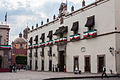 Casa de la Corregidora in Querétaro City.
 -

-
 Chapel of Our Lady of Guadalupe in San Juan del Río.


- State of Guanajuato
1351-011: Bridge of El Fraile.
1351-012: Former Royal Hospital of San Juan de Dios in San Miguel de Allende.
1351-013: Bridge of San Rafael in Guanajuato City.
1351-014: Bridge La Quemada.
1351-015: San Miguel de Allende and Sanctuary of Jesús Nazareno de Atotonilco.
1351-016: Historic center of Guanajuato City and its adjacent mines.
-
-
 Church of Nuestra Señora de la Salud in San Miguel Allende.
 -
 Parish of San Miguel Arcángel in San Miguel Allende.
 -
Sanctuary of Jesús Nazareno de Atotonilco.
-
-
 Guanaguato City panorama.
 -
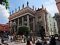 Juárez Theatre in Guanajuato City.


List of World Heritage locations


The Camino Real de Tierra Adentro world heritage entry includes the following:[10]
United States Historic Trail
From the Texas-New Mexico border to San Juan Pueblo north of Española, a drivable route, mostly part of former U.S. Route 85, has been designated as a National Scenic Byway called El Camino Real.
Portions of the trade route corridor also contain pedestrian, bicycle, and equestrian trails. These include the existing Paseo del Bosque Trail in Albuquerque and portions of the proposed Rio Grande Trail. Its northern terminus, Santa Fe, is a terminus also of the Old Spanish Trail and the Santa Fe Trail.
Along the trail, parajes (stop overs) that have been preserved today include El Rancho de las Golondrinas.
Fort Craig and Fort Selden are also located along the trail.
CARTA
El Camino Real de Tierra Adentro Trail Association (CARTA) is a non-profit trail organization that aims to help promote, educate, and preserve the cultural and historic trail in collaboration with the National Park Service, the Bureau of Land Management, the New Mexico Department of Cultural Affairs and various Mexican organizations. CARTA publishes an informative journal, Chronicles of the Trail, quarterly that provides people with further history and current affairs of the trail and what CARTA, as an organization, is doing to help the trail.
Chihuahua Trail
The Chihuahua Trail describes this route as it passed from New Mexico through the state of Chihuahua to central Mexico.
In the late 16th century Spanish exploration and colonization had advanced from Mexico City northward by the great central plateau to its ultimate goal in Santa Fe. Until Mexican independence (1821) all communications of New Mexico with the outer world was restricted to this 1,500-mile (2,400 km) trail. Over it came ox carts and mule trains, missionaries and governors, soldiers and colonists. When the Santa Fe Trail sprang up, traders from the United States extended their operations southward over the Chihuahua Trail and beyond to Durango and Zacatecas. Superseded by railroads, the ancient Mexico City-Santa Fe road was revived as a great automobile highway of Mexico. The part in New Mexico, State Highway 85, pioneered by Franciscan missionaries in 1581, may be the oldest highway in the United States.
See also
- El Camino Real (California) – The California Mission Trail
- El Camino Real de Los Tejas – El Camino Real from Texas east to Louisiana
- Old San Antonio Road – A section of El Camino Real de Los Tejas
- Scenic byways in the United States
- National Register of Historic Places listings in Socorro County, New Mexico
References
- ^ Snyder, Rachel Louise. "Camino Real" American Heritage, April/May 2004.
- ^ "Camino Real de Tierra Adentro – World Heritage List". UNESCO. Retrieved 5 August 2010.
- ^ "Weekly list of actions 11/03/14 through 11/07/14". National Park Service. Retrieved 23 November 2014.
- ^ http://www.colpos.mx/asyd/volumen8/numero2/res-11-001.pdf
- ^ http://www.educacion.gob.es/exterior/centros/albuquerque/es/newmexico/CaminoReal.pdf
- ^ a b http://www.saber.ula.ve/bitstream/123456789/28985/1/articulo1.pdf
- ^ "Linea de Presidios de la Frontera Novohispana: 1770 - 1780". cachanilla69.blogspot.mx.
- ^ UNESCO World Heritage Convention (2010). "List of sites of the Camino Real de Tierra Adentro".
- ^ http://vamonosalbable.blogspot.mx/search/label/Unesco
- ^ "Camino Real de Tierra Adentro Map". whc.unesco.org.
Further reading
- Dictionary of American History by James Truslow Adams, New York: Charles Scribner's Sons, 1940
- Boyle, Susan Calafate. Los Capitalistas: Hispano Merchants and the Santa Fe Trade. Albuquerque: University of New Mexico Press, 1997.
- Moorhead, Max L. New Mexico’s Royal Road. Norman: University of Oklahoma Press, 1958.
- Palmer, Gabrielle G., et al.. El Camino Real de Tierra Dentro. Santa Fe: Bureau of Land Management, 1993.
- Palmer, Gabrielle G. and Stephen L. Fosberg. El Camino Real de Tierra Dentro. Santa Fe: Bureau of Land Management, 1999.
- Preston, Douglas and José Antonio Esquibel. The Royal Road. Albuquerque: University of New Mexico Press, 1998.
External links
- National Park Service: official El Camino Real de Tierra Adentro National Historic Trail website
- El Camino Real International Heritage Center
- El Camino Real de Tierra Adentro – Integrated education curriculum
- CARTA – El Camino Real de Tierra Adentro Trail Association: website
- N.M.-Monuments.org – "A Road Over Time"
- Historic trails and roads in Mexico
- Historic trails and roads in New Mexico
- Historic trails and roads in Texas
- Colonial Mexico
- Colonial New Mexico
- New Spain
- Spanish Texas
- National Historic Trails of the United States
- National Scenic Byways
- Bureau of Land Management areas in New Mexico
- Historic Civil Engineering Landmarks
- Protected areas established in 2000
- Units of the National Landscape Conservation System
- Roads on the National Register of Historic Places in New Mexico
- New Mexico Scenic and Historic Byways
- World Heritage Sites in Mexico
- National Register of Historic Places in Socorro County, New Mexico
- 2000 establishments in Texas
- 2000 establishments in New Mexico
- 2000 establishments in Mexico