Santa María de Huerta: Difference between revisions
Jump to navigation
Jump to search
Content deleted Content added
ILoveCaracas (talk | contribs) No edit summary |
ILoveCaracas (talk | contribs) No edit summary |
||
| Line 1: | Line 1: | ||
{{unreferenced|date=January 2013}} |
{{unreferenced|date=January 2013}} |
||
{{Infobox settlement |
|||
<!--See Template:Infobox settlement for additional fields that may be available--> |
|||
<!--See the Table at Infobox settlement for all fields and descriptions of usage--> |
|||
official_name = Santa María de Huerta, Spain | |
|||
<!-- Basic info ----------------> |
|||
nickname = |
|||
|name = Santa María de Huerta |
|||
image_flag = | |
|||
|official_name = <!-- ''Santa María de Huerta'' --> |
|||
image_seal = | |
|||
|native_name = |
|||
image_map = | |
|||
|native_name_lang = |
|||
map_caption = | |
|||
|settlement_type = [[Municipalities in Spain|Municipality]] |
|||
subdivision_type = [[List of countries|Country]] | |
|||
|image_skyline = Monasterio de Santa María de Huerta - Fachada iglesia y entrada monsterio.jpg |
|||
subdivision_name = [[Spain]] | |
|||
|image_caption = Monasterio de Santa María de Huerta |
|||
subdivision_type1 = [[Autonomous communities of Spain|Autonomous community]] | |
|||
|image_flag = |
|||
subdivision_name1 = [[Castile and León]] | |
|||
|flag_size = |
|||
subdivision_type2 = [[Provinces of Spain|Province]] | |
|||
|image_seal = |
|||
subdivision_name2 = [[Soria (province)|Soria]] | |
|||
|seal_size = |
|||
subdivision_type3 = [[List of municipalities in Soria|Municipality]] | |
|||
|image_shield = Escudo de SantaMariadeHuerta.svg |
|||
subdivision_name3 = Santa María de Huerta | |
|||
|shield_size = 90px |
|||
leader_title = | |
|||
|image_blank_emblem = |
|||
leader_name = | |
|||
|blank_emblem_type = |
|||
area_magnitude = | |
|||
|blank_emblem_size = |
|||
area_total_km2 = 48 | |
|||
|nickname = |
|||
area_land_km2 = | |
|||
|motto = |
|||
area_water_km2 = | |
|||
<!-- images and maps -----------> |
|||
elevation_m = 762 | |
|||
|image_map = |
|||
population_as_of = 2004 | |
|||
|mapsize = |
|||
population_note = | |
|||
|map_caption = Location of Santa María de Huerta within Spain / Castile and León |
|||
population_total = 419 | |
|||
|pushpin_map = Spain#Spain Castile and León#Europe |
|||
population_density_km2 = 8.7 | |
|||
|pushpin_label_position= |
|||
timezone = [[Central European Time|CET]] | |
|||
|pushpin_mapsize = 250 |
|||
utc_offset = +1 | |
|||
<!-- Location ------------------> |
|||
timezone_DST = [[Central European Summer Time|CEST]] | |
|||
|pushpin_map_caption = |
|||
utc_offset_DST = +2 | |
|||
|coordinates = {{coord|41|15|53|N|2|10|33|W|region:ES|display=inline,title}} |
|||
latitude = | |
|||
|subdivision_type =[[Countries of the world|Country]] |
|||
longitude = | |
|||
|subdivision_name ={{flag|Spain}} |
|||
website = | |
|||
|subdivision_type1 =[[Autonomous communities of Spain|Autonomous Community]] |
|||
footnotes = | |
|||
|subdivision_type2 =[[Provinces of Spain|Province]] |
|||
|subdivision_type3 =[[Comarcas of the Valencian Community|Comarca]] |
|||
|subdivision_name1 ={{flag|Castile and León}} |
|||
|subdivision_name2 =[[Province of Soria|Soria]] |
|||
|subdivision_name3 =[[Campo de Gómara]] |
|||
|established_title =Founded |
|||
|established_date = |
|||
<!-- Area ---------------------> |
|||
|parts_type =Districts |
|||
|parts_style = |
|||
|p1= |
|||
|government_footnotes = |
|||
|government_type =[[Mayor-council government]] |
|||
|governing_body =Ayuntamiento de Santa María de Huerta |
|||
|leader_party =[[Independent Grouping of Santa María de Huerta|AISMH]] |
|||
|leader_title =[[Alcalde|Mayor]] |
|||
|leader_name =[[Mercedes Aguilar Medina]] (2015) |
|||
|total_type =<!-- to set a non-standard label for total area and population rows --> |
|||
|unit_pref =<!--Enter: Imperial, to display imperial before metric--> |
|||
|area_footnotes = |
|||
|area_magnitude = |
|||
|area_total_km2 =49.15 |
|||
|area_total_sq_mi = |
|||
|area_land_km2 =<!--See table @ Template:Infobox settlement for details on unit conversion--> |
|||
|area_land_sq_mi = |
|||
|area_water_km2 = |
|||
|area_water_sq_mi = |
|||
|area_water_percent = |
|||
<!-- Elevation --------------------------> |
|||
|elevation_footnotes = <!--for references: use<ref> tags--> |
|||
|elevation_m = 762 |
|||
|elevation_ft = |
|||
<!-- Population -----------------------> |
|||
|population_total = 300 |
|||
|population_as_of = 2016 |
|||
|population_footnotes = [[Instituto Nacional de Estadística (Spain)|INE]] |
|||
|population_density_km2= auto |
|||
|population_density_sq_mi= |
|||
|population_est = |
|||
|pop_est_as_of = |
|||
|population_urban = |
|||
|population_metro = |
|||
|population_demonym = ''Hortense'', ''-sa'' ([[Spanish language|es]]) |
|||
<!-- General information ---------------> |
|||
|population_note = |
|||
|timezone1 = CET (GMT +1) |
|||
|utc_offset1 = |
|||
|timezone1_DST = CEST (GMT +2) |
|||
|utc_offset1_DST = |
|||
|postal_code_type =Postcode |
|||
|postal_code = 42260 |
|||
|area_code = |
|||
|blank_name_sec1 = |
|||
|blank_info_sec1 = ES-CL |
|||
|website = |
|||
|footnotes = |
|||
|image_dot_map = |
|||
|dot_mapsize = |
|||
|dot_map_caption = |
|||
|dot_x= |
|||
|dot_y= |
|||
<!-- Politics -----------------> |
|||
|twin1 = |
|||
}} |
}} |
||
Revision as of 21:24, 20 December 2017
Santa María de Huerta | |
|---|---|
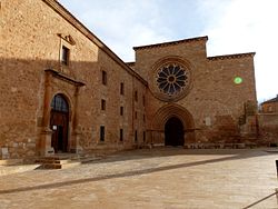
 Monasterio de Santa María de Huerta | |
| Coordinates: 41°15′53″N 2°10′33″W / 41.26472°N 2.17583°W | |
| Country | |
| Autonomous Community | |
| Province | Soria |
| Comarca | Campo de Gómara |
| Government | |
| • Type | Mayor-council government |
| • Body | Ayuntamiento de Santa María de Huerta |
| • Mayor | Mercedes Aguilar Medina (2015) (AISMH) |
| Area | |
| • Total | 49.15 km2 (18.98 sq mi) |
| Elevation | 762 m (2,500 ft) |
| Population (2016) INE | |
| • Total | 300 |
| • Density | 6.1/km2 (16/sq mi) |
| Demonym(s) | Hortense, -sa (es) |
| Time zone | CET (GMT +1) |
| • Summer (DST) | CEST (GMT +2) |
| Postcode | 42260 |
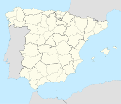
Santa María de Huerta is a municipality located in the province of Soria, Castile and León, Spain. According to the 2004 census (INE), the municipality has a population of 419 inhabitants.
41°16′N 2°10′W / 41.267°N 2.167°W{{#coordinates:}}: cannot have more than one primary tag per page


