Albaicín: Difference between revisions
| Line 83: | Line 83: | ||
*Lona House in Lona Lane, on the site of the former palace of the kings Ziries. |
*Lona House in Lona Lane, on the site of the former palace of the kings Ziries. |
||
*Cordova Palace (16th century) in the Cuesta del Chapiz, current Municipal Archives. |
*Cordova Palace (16th century) in the Cuesta del Chapiz, current Municipal Archives. |
||
*Casa del Chapiz, This was built on the remains of a Moorish palace of the 14th century, which preserves part of the layout of the plant and some elements that were utilized when it was rebuilt in the early 16th century by the Morisco Lorenzo el Chapiz, whose name is preserved in the set and the street where it is located |
|||
==See also== |
==See also== |
||
Revision as of 00:34, 9 June 2016
This article relies largely or entirely on a single source. (April 2016) |
| UNESCO World Heritage Site | |
|---|---|
.jpg?lang=en) | |
| Criteria | Cultural: i, iii, iv |
| Reference | 314 |
| Inscription | 1984 (8th Session) |
| Extensions | 1994 |
El Albayzín (also Albaicín, Spanish pronunciation: [alβai̯ˈθin]) is a district of Granada, in the autonomous community of Andalusia, Spain, that retains the narrow winding streets of its Medieval Moorish past. It was declared a world heritage site in 1984, along with the famous Alhambra.
History

It was populated in Iberian period and Roman dispersed settlement existed. There is no data before the arrival of the Zirid Berber Islamic settlement, so it is assumed that the city was abandoned since the end of the Roman Empire until the founding of the Zirid kingdom in 1013 when it was surrounded by big walls. According to some linguists it owes its present name to the inhabitants of the city of Baeza who banished her after the battle of Las Navas de Tolosa, settled in this area of Granada outside the existing walls. Other linguists claim that the name comes from the Arabic al-bayyāzīn (as its pronounced with imala, al-bayyīzīn),meaning the suburb of falconers. However, the fact that in Andalusia there are many other neighborhoods with that name, in Sanlúcar de Barrameda (Cádiz), Alhama de Granada, Salobreña and Huéneja (Granada), Antequera and Villanueva de Algaidas (Málaga), Baena (Córdoba) porcuna and Sabiote (Jaén), and Constantina (Sevilla), doubts this thesis. There are also neighborhoods with that name in other parts of Spain, as in Campo de Criptana (Ciudad Real), result of the expulsion of the Moors after the Revolt of the Alpujarras or in Pastrana (Guadalajara), this neighborhood created by Doña Ana de Eboli to accommodate the Moorish Kingdom of Granada.
Is one of the oldest centers of Muslim culture in Granada, with the Alhambra, the Realejo and Arrabal de Bib-Arrambla, on the flat part of the city.
Before the Muslim conquest of the Iberian Peninsula, in what is now the city of Granada and its surroundings there were three small populations:
- Iliberis (Elvira), what was later called Albaicin and Alcazaba
- Castilia, near the present town of Atarfe
- Garnata, on the opposite hill to the Alcazaba, which was more a neighborhood of Iliberis.


However, after these classic statements, current archaeological research, Madinat Ilbira located in Atarfe until the 11th century when that city was moved to the Albaicin after the fall of the Caliphate and the insecurity it generates. The inhabitants of Ilbira undergo as clients Sinhaya and ziríes and it is decided the transfer of the capital of the Cora de Elvira to Hill Albaicín
In the 756 Arabs are already in the peninsula. It is the time of Independent Emirate. The Arab population is manifested in two centers: the Albaicín and the Alhambra.
This neighborhood had its greatest influence at the time of the Nazari. The Albaicín maintains the urban fabric of the Moorish period, with narrow streets, in an intricate network that extends from the top (St. Nicholas) through the course of the river Darro and Calle Elvira, both located in Plaza Nueva.
In December 1499, Albaicín become the starting point of a rebellion throughout Granada, which were triggered by the forced conversions of the Muslim population to Christianity.[1]
The traditional type of house is the carmen, consisting of a free house surrounded by a high wall that separates it from the street and includes a small orchard or garden.
It was characteristic of this district the channeling and distribution of drinking water through wells; in all there were found about 28; of which a large majority is preserved but is not in use because its pipes are broken over time.
19th century paintings of Albayzín
-
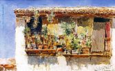 A balcony in Albayzín by painter M. Arroyo Fernandez in 1891, stored at Biblioteca Provincial de Granada
 -
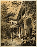 Casa del Chapiz in the Albayzín by Francesc Pi i Margall and Francesc Xavier Parcerisa in 1850, published in the work Recuerdos y bellezas de España
 -
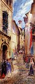 Procession of the Viaticum on the street of Zafra, Albayzín by Manuel Ruiz Sanchez Morales (1853-1922), stored at Biblioteca Provincial de Granada
 -
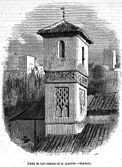 Tower of San Lorenzo in the Albayzín. Drawing by Federico Ruiz (1837-1868), engraving by Edward Skill (1831-1873), published in the Spanish magazine El Museo Universal

.jpg?lang=en)


In 1994, the Albaicín was declared World Heritage by UNESCO as an extension of the monuments of the Alhambra and Generalife.[2]
Places of interest
In the Albaicín there are numerous monuments from different periods, mainly the nazari period and the Renaissance:
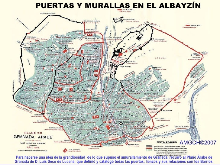
- Ziri wall (11th century), established along the Sacromonte and Albaicín.
- New door or door of Weights, the Grenadian people call and know it as arc of weights.[3]
- Fajalauza door in Cuesta de San Gregorio Alto, part of the wall.[4]-[5]
- Alhacaba Towers, part of the wall.
- Monaita door in Lona Lane, part of the wall.
- Puerta de Elvira, at the beginning of Calle Elvira, part of the wall.
- Church of El Salvador, in the Cuesta del Chapiz.
- Church of San Miguel Bajo, in the small square of San Miguel Bajo, with a Mudejar armor and a cistern of the 13th century.
- Church of San Gregorio, at the beginning of the Cuesta de San Gregorio.
- Church of San Cristobal and viewpoint with the same name, in Crta. De Murcia
- St. Louis. Temple without worship and in ruins.
- Church of San Juan de los Reyes, in the street San Juan de los Reyes.
- Palace of Dar al-Horra, Aixa residence, Muley Hacén wife and mother of Boabdil.
- The Bañuelo.
- Minaret of Almorabitun.
- Trillo cistern.
- House of the Masks, in the street Pagés, what remains of the house of the poet Pedro Soto de Rojas (17th century).
- House Yanguas (16th century), at San Buenaventura, hodgepodge of Nazari and Renaissance architecture. Currently, Tourist hotel.
- Church of Santa Ana, at the beginning of the Carrera del Darro.
- Saint Peter and Saint Paul, in the Carrera del Darro.
- Hermitage of San Miguel alto, Lane San Miguel ..
- Casa de Porras, in Placeta de Porras, Moorish house of the 16th century, today the University Cultural Center of the University of Granada.
- Casa del Almirante (Aragon), Calle San José, 16th century.
- Castril House (1539) in the Carrera del Darro, Current Archaeological Museum of Granada.
- Lona House in Lona Lane, on the site of the former palace of the kings Ziries.
- Cordova Palace (16th century) in the Cuesta del Chapiz, current Municipal Archives.
- Casa del Chapiz, This was built on the remains of a Moorish palace of the 14th century, which preserves part of the layout of the plant and some elements that were utilized when it was rebuilt in the early 16th century by the Morisco Lorenzo el Chapiz, whose name is preserved in the set and the street where it is located
See also
Gallery
-
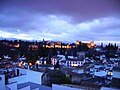 The Alhambra seen from across the Albayzín
 -
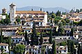
 Houses in the Albayzín
 -
 Typical house façade in Cuesta de Alhacaba
 -
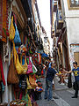 Calderería street
 -
 Church of San Nicolas and Albayzín from Alhambra palace


.JPG?lang=en)


References
- ^ Carr, Matthew (2009). Blood and Faith: The Purging of Muslim Spain. New Press. pp. 58–59. ISBN 978-1-59558-361-1.
{{cite book}}: Invalid|ref=harv(help) - ^ "Alhambra, Generalife and Albayzín, Granada". UNESCO Culture Sector. Retrieved 09-02-2013.
{{cite web}}: Check date values in:|access-date=(help) - ^ Plano árabe de Granada de Luis Seco de Luna
- ^ Ayuntamiento de Granada. AGENCIA albaicin GRANADA
- ^ GALLEGO Y BURÍN, ANTONIO. "Guía artística e histórica de la ciudad de Granada", página, 781. Edición: Guía de Granada 1946.
External links
- Albayzín on ArchNet, retrieved October 24, 2006
- World Heritage page on Albayzín , retrieved October 24, 2006
- Albayzín in turgranada.es Official Site for tourism of the province of Granada
- Albayzín in granada-in.com Itineraries by the district of the Albaicin (in Spanish)
- Webcam Albayzín - Granada/Alhambra
8 [1]
