Malabo: Difference between revisions
No edit summary |
|||
| Line 55: | Line 55: | ||
|footnotes = |
|footnotes = |
||
}} |
}} |
||
'''Malabo''' {{IPAc-en|m|ə|ˈ|l|ɑː|b|oʊ}} is the [[ |
'''Malabo''' {{IPAc-en|m|ə|ˈ|l|ɑː|b|oʊ}} it is the [[capital (political)|capital]] and largest city of [[Equatorial Guinea]] and of [[provinces of Equatorial Guinea|province]] of [[Bioko Norte Province|Bioko Norte]]. It is located on the north coast of the island of [[Bioko]] -island formerly known by the [[Bubi]]s, its autocthonous inhabitants, as ''Etulá'' and as ''[[Fernando Poo]]'' by the Europeans and has a population of approximately of 187,302 inhabitants. |
||
The [[language]]s city officials, as well as across the country, are the [[Spanish language|Spanish]] (main language and practically the only one used), the [[French language|French]] and [[Portuguese language|Portuguese]]. |
|||
| ⚫ | |||
The city was first founded by the British in 1827, who leased the island from [[Spain]] during the colonial period. Named '''Port Clarence''', it was used as a naval station in the effort to suppress the slave trade. Many newly [[freed slaves]] were also settled there, prior to the establishment of [[Liberia]] as a colony for freed slaves. While many of them later relocated to [[Sierra Leone]], some of their descendants, called [[Fernandinos]], can still be found in Malabo and the surrounding area, where they constitute a distinct ethnic group, speaking their own [[Afro-Portuguese]] [[pidgin]] dialect. |
|||
Malabo is the oldest city of Equatorial Guinea. That is why it can see a lot of buildings with [[colonial architecture]] at the same time coexist with modern buildings built in the last and recent stage. The downtown streets, with a square design, reveal the ancient conception of modern city with [[pedestrian areas]] at all. The city also offers numerous [[green areas]] and leisure. This phenomenon causes a feeling of architecture attenuated by the low height of buildings in a combination of architectural Westernization and Africanism. |
|||
When the island reverted to complete Spanish control, Malabo was renamed '''Santa Isabel'''. It was chosen to replace the mainland city of [[Bata, Equatorial Guinea|Bata]] as the capital of the country in 1969, and was renamed Malabo in 1973 as part of President [[Francisco Macías Nguema]]'s campaign to replace European place names with "authentic" African ones. |
|||
[[Oyala]] is a [[planned city]] currently under construction, designed to replace Malabo as the capital. |
|||
| ⚫ | |||
===Discovery and Portuguese conquest=== |
|||
In [[1472]], in an attempt to find a new route to the [[India]], the [[Portugal|Portuguese]] navigator [[Fernão do Pó]], discovered the island of Bioko, which He called "Fermosa". Later the island was named after its discoverer, Fernando Poo. At the beginning of [[16th century]], specifically in 1507, the Portuguese [[Ramos de Esquivel]] made a first attempt at colonization on the island of Fernando Poo. He established a [[factory]] in ''[[Riaba|Concepción]]'' (current Riaba) and developed plantations of [[sugarcane]], but the hostility of the insular Bubi people and diseases ended this experience quickly. |
|||
[[File:Abayak, Malabo08230.JPG|thumb|left|250px|Abayak neighborhood, west of Malabo.]] |
|||
With the treaties of [[Treaty of San Ildefonso (1777)|San Ildefonso]] in [[1777]] and [[Treaty of El Pardo (1778)|El Pardo]] in [[1778]], during the reign of the Spanish King Carlos III the Portuguese gave to the Spanish island of Fernando Poo, Annobón and the right to conduct trade in the mainland, an area of influence approximately of 800 000 [[km²]] in Africa, in exchange for the [[Colonia del Sacramento]] in the [[River Plate]] and the [[island of Santa Catarina|Santa Catalina Island]] off the [[Brazil]]ian coast (occupied by the Spaniards). The area stretching from the [[Niger Delta]] to the mouth of [[Ogooué River|Ogüé River]] -in the current [[Gabon]]- and included, besides the islands of Fernando Poo and [[Annobon]], the islets of Corisco and Elobeyes. Failed its various unsuccessful attempts to colonize these lands, Spain for its internal problems, lost interest in Spanish Guinea in 1827 and authorized the British use the island as a base for the work of persecution of the Slave Trade. |
|||
===British Presence=== |
|||
In [[1821]], the British captain Nelly approached the island of Fernando Poo. He found abandoned and founded the establishments of ''[[Riaba|Melville Bay]]'' (Riaba) and ''[[San Carlos de Luba|San Carlos]]'' (Luba). Some years later, another British captain, [[William Fitzwilliam Owen]] decided to colonize the island and set in the north of it -in the site of the present capital- a base for British ships chasing European dealers of [[African slave trade|slaves]]. Thus arises, the [[December 25]] of [[1827]] ''Port Clarence'' on the ruins of a previous Portuguese settlement. The name was chosen in honor of the Duke of Clarence, who later became Williams IV. The [[Bubi]]s indigenous to the island called it "''Ripotó'' (''«place of the foreigners»''). The population of the capital was increased by the arrival of freed slave of ship captured by the British navy who decided to stay and live on the island. The settlement of the freedmen in Port Clarence preceded the formation of [[Sierra Leone]] as a colony for freed slaves. The descendants of these people enslaved and freed remain on the island. At they joined other migrants arrived as free workers from Liberia, Sierra Leone, Ghana, Ivory Coast, Benin, Nigeria and Cameroon, constituting the population group called Creole or [[fernandino]]s, and whose own language the [[Pidgin]] Bantu-English with Spanish elements. |
|||
During the period of the British presence, British consuls automatically became governors of the colony. Including Governor John Beecroft, a British mulatto sailor who modernized the capital, whose work was recognized later by Spain erecting a monument which is located in Punta Fernanda. |
|||
[[File: Reymalabo1930.PNG|thumb|160px|right|[[Malabo Lopelo Melaka|Malabo Löpèlo Mëlaka, Malabo I on Bioko]].]] |
|||
=== Spanish definitive control and new capital === |
|||
In 1844, when Queen Elizabeth II ruled after the regency of her mother Maria Cristina and [[Baldomero Espartero]], in an attempt to modernize Spain and rescuing its heritage, Spain let him know the UK its desire to be of regain control of the colony and thus the island. It took another decade to implement this direct control. The capital already had more dynamic and Protestant religious missions were very successful. Both factors helped to change the attitude of Spain, in addition to internal reasons already alluded. |
|||
Spain again took control of the island in 1855 and the capital ''Port Clarence'' was renamed ''Santa Isabel'', in honor of the queen [[Isabel II of Spain]]. The capital of the island of Fernando Poo became the capital of Equatorial Guinea. |
|||
Its present name was given in [[1973]] as part of the campaign of President [[Francisco Macías Nguema|Macías Nguema]] to replace the [[place name]]s of European origin with African names properly, honoring [[Malabo Lopelo Melaka]], the last Bubi king. Malabo, son of King Moka, surrendered to the Spaniards, while his uncle Sas Ebuera, head of the Bubi warriors, claimed the legitimacy of Bubi rule and opposed with value to the Spaniards. After the murder of Sas Ebuera by the Spanish, Malabo became king without opposed, but without authority. Bubi clans and localities were slow to accept Spanish sovereignty over the island, and even [[1912]] was not achieved by conquest and pacification of the whole island. |
|||
===Reign of Terror=== |
|||
During the so-called ''Reign of Terror'' of [[Francisco Macías Nguema|Macías Nguema]], the dictator suppressed much of the intelligentsia of the country, initiating the process of taking over the positions of the public administration, by part of the natives of Mongomo and clan Esangui. Many city residents had to leave. In the last years of his mandate, almost a fifth of the population fled. Still today Malabo tries to heal his wounds from that period, while the successor as head of state, [[Teodoro Obiang Nguema]] with his [[Democratic Party of Equatorial Guinea]], dictator from [[1979]] by a coup that overthrew Macías has not made improvements of any kind. |
|||
Behind the near the barracks next to Governor's palace, next to a black beach at the mouth of the Cónsul River, is the shameful and famous [[Black Beach prison]] also known as ''Blay Beach prison'' (or Playa Negra prison) where several people have been jailed in the over 35 years of dictatorship. Among those imprisoned and tortured numerous times are many political leaders as Fabián Nsue (UP), Felipe Ondo Obiang (FDR), Martín Puye of [[Movement for the Self-Determination of Bioko Island]] (MAIB) or [[Plácido Micó]] of the Social Democratic [[Convergence for Social Democracy]] (CPDS). |
|||
==Climate== |
==Climate== |
||
Revision as of 18:41, 7 September 2015
This article needs additional citations for verification. (November 2009) |
Malabo | |
|---|---|
 Venus Bay | |
 Flag .svg?lang=en) Seal | |
| Country | |
| Province | Bioko Norte Province |
| Founded | 1827 |
| Current name | Since 1973 |
| Elevation | 0 m (0 ft) |
| Population (2012) | |
| • Total | 187,302 |
| Demonym | Malabeño-a |
| Time zone | UTC+1 (WAT) |
| Website | www |
Malabo /məˈlɑːboʊ/ it is the capital and largest city of Equatorial Guinea and of province of Bioko Norte. It is located on the north coast of the island of Bioko -island formerly known by the Bubis, its autocthonous inhabitants, as Etulá and as Fernando Poo by the Europeans and has a population of approximately of 187,302 inhabitants.
The languages city officials, as well as across the country, are the Spanish (main language and practically the only one used), the French and Portuguese.
Malabo is the oldest city of Equatorial Guinea. That is why it can see a lot of buildings with colonial architecture at the same time coexist with modern buildings built in the last and recent stage. The downtown streets, with a square design, reveal the ancient conception of modern city with pedestrian areas at all. The city also offers numerous green areas and leisure. This phenomenon causes a feeling of architecture attenuated by the low height of buildings in a combination of architectural Westernization and Africanism.
Oyala is a planned city currently under construction, designed to replace Malabo as the capital.
History
Discovery and Portuguese conquest
In 1472, in an attempt to find a new route to the India, the Portuguese navigator Fernão do Pó, discovered the island of Bioko, which He called "Fermosa". Later the island was named after its discoverer, Fernando Poo. At the beginning of 16th century, specifically in 1507, the Portuguese Ramos de Esquivel made a first attempt at colonization on the island of Fernando Poo. He established a factory in Concepción (current Riaba) and developed plantations of sugarcane, but the hostility of the insular Bubi people and diseases ended this experience quickly.

With the treaties of San Ildefonso in 1777 and El Pardo in 1778, during the reign of the Spanish King Carlos III the Portuguese gave to the Spanish island of Fernando Poo, Annobón and the right to conduct trade in the mainland, an area of influence approximately of 800 000 km² in Africa, in exchange for the Colonia del Sacramento in the River Plate and the Santa Catalina Island off the Brazilian coast (occupied by the Spaniards). The area stretching from the Niger Delta to the mouth of Ogüé River -in the current Gabon- and included, besides the islands of Fernando Poo and Annobon, the islets of Corisco and Elobeyes. Failed its various unsuccessful attempts to colonize these lands, Spain for its internal problems, lost interest in Spanish Guinea in 1827 and authorized the British use the island as a base for the work of persecution of the Slave Trade.
British Presence
In 1821, the British captain Nelly approached the island of Fernando Poo. He found abandoned and founded the establishments of Melville Bay (Riaba) and San Carlos (Luba). Some years later, another British captain, William Fitzwilliam Owen decided to colonize the island and set in the north of it -in the site of the present capital- a base for British ships chasing European dealers of slaves. Thus arises, the December 25 of 1827 Port Clarence on the ruins of a previous Portuguese settlement. The name was chosen in honor of the Duke of Clarence, who later became Williams IV. The Bubis indigenous to the island called it "Ripotó («place of the foreigners»). The population of the capital was increased by the arrival of freed slave of ship captured by the British navy who decided to stay and live on the island. The settlement of the freedmen in Port Clarence preceded the formation of Sierra Leone as a colony for freed slaves. The descendants of these people enslaved and freed remain on the island. At they joined other migrants arrived as free workers from Liberia, Sierra Leone, Ghana, Ivory Coast, Benin, Nigeria and Cameroon, constituting the population group called Creole or fernandinos, and whose own language the Pidgin Bantu-English with Spanish elements.
During the period of the British presence, British consuls automatically became governors of the colony. Including Governor John Beecroft, a British mulatto sailor who modernized the capital, whose work was recognized later by Spain erecting a monument which is located in Punta Fernanda.

Spanish definitive control and new capital
In 1844, when Queen Elizabeth II ruled after the regency of her mother Maria Cristina and Baldomero Espartero, in an attempt to modernize Spain and rescuing its heritage, Spain let him know the UK its desire to be of regain control of the colony and thus the island. It took another decade to implement this direct control. The capital already had more dynamic and Protestant religious missions were very successful. Both factors helped to change the attitude of Spain, in addition to internal reasons already alluded.
Spain again took control of the island in 1855 and the capital Port Clarence was renamed Santa Isabel, in honor of the queen Isabel II of Spain. The capital of the island of Fernando Poo became the capital of Equatorial Guinea.
Its present name was given in 1973 as part of the campaign of President Macías Nguema to replace the place names of European origin with African names properly, honoring Malabo Lopelo Melaka, the last Bubi king. Malabo, son of King Moka, surrendered to the Spaniards, while his uncle Sas Ebuera, head of the Bubi warriors, claimed the legitimacy of Bubi rule and opposed with value to the Spaniards. After the murder of Sas Ebuera by the Spanish, Malabo became king without opposed, but without authority. Bubi clans and localities were slow to accept Spanish sovereignty over the island, and even 1912 was not achieved by conquest and pacification of the whole island.
Reign of Terror
During the so-called Reign of Terror of Macías Nguema, the dictator suppressed much of the intelligentsia of the country, initiating the process of taking over the positions of the public administration, by part of the natives of Mongomo and clan Esangui. Many city residents had to leave. In the last years of his mandate, almost a fifth of the population fled. Still today Malabo tries to heal his wounds from that period, while the successor as head of state, Teodoro Obiang Nguema with his Democratic Party of Equatorial Guinea, dictator from 1979 by a coup that overthrew Macías has not made improvements of any kind.
Behind the near the barracks next to Governor's palace, next to a black beach at the mouth of the Cónsul River, is the shameful and famous Black Beach prison also known as Blay Beach prison (or Playa Negra prison) where several people have been jailed in the over 35 years of dictatorship. Among those imprisoned and tortured numerous times are many political leaders as Fabián Nsue (UP), Felipe Ondo Obiang (FDR), Martín Puye of Movement for the Self-Determination of Bioko Island (MAIB) or Plácido Micó of the Social Democratic Convergence for Social Democracy (CPDS).
Climate
Malabo features a tropical monsoon climate. Malabo sees on average 1,800 mm of rain per year. The city has a pronounced, albeit short dry season from December through February. February is normally its driest with 33 mm (0.2 in) of rain falling on average. It also has a very lengthy wet season that covers the remaining nine months. On average, the months hit hardest by the wet season are from September to October, with 500 millimetres (20 in) of rain falling between them.
Daytime temperatures do not vary at all day to day, and only vary a few degrees throughout the entire year. At night, the average low temperature is 21-22 degrees in every month of the year, apart from January when average low is 19 degrees). January has cooler nights and hotter days because it has clearer weather. Nonetheless, Malabo, with only 1,180 hours of sunshine per year, is one of the gloomiest capitals in the world and experiences much fog even when it is not raining.
| Climate data for Malabo | |||||||||||||
|---|---|---|---|---|---|---|---|---|---|---|---|---|---|
| Month | Jan | Feb | Mar | Apr | May | Jun | Jul | Aug | Sep | Oct | Nov | Dec | Year |
| Mean daily maximum °C (°F) | 31 (88) |
32 (90) |
31 (88) |
32 (90) |
31 (88) |
29 (84) |
29 (84) |
29 (84) |
30 (86) |
30 (86) |
30 (86) |
31 (88) |
30 (86) |
| Daily mean °C (°F) | 25 (77) |
26 (79) |
26 (79) |
26 (79) |
25 (77) |
25 (77) |
24 (75) |
24 (75) |
24 (75) |
24 (75) |
25 (77) |
25 (77) |
25 (77) |
| Mean daily minimum °C (°F) | 19 (66) |
21 (70) |
21 (70) |
21 (70) |
22 (72) |
21 (70) |
21 (70) |
21 (70) |
21 (70) |
21 (70) |
22 (72) |
21 (70) |
21 (70) |
| Average rainfall mm (inches) | 42 (1.7) |
33 (1.3) |
110 (4.3) |
187 (7.4) |
179 (7.0) |
224 (8.8) |
284 (11.2) |
188 (7.4) |
277 (10.9) |
238 (9.4) |
92 (3.6) |
36 (1.4) |
1,890 (74.4) |
| Average rainy days (≥ 0.1 mm) | 4 | 4 | 11 | 14 | 18 | 21 | 21 | 18 | 23 | 20 | 13 | 5 | 172 |
| Average relative humidity (%) | 86 | 85 | 90 | 89 | 87 | 90 | 90 | 92 | 95 | 94 | 93 | 91 | 90 |
| Mean monthly sunshine hours | 148.8 | 152.5 | 108.5 | 120.0 | 117.8 | 69.0 | 46.5 | 58.9 | 48.0 | 68.2 | 99.0 | 139.5 | 1,176.7 |
| Source: Climate & Temperature[1] | |||||||||||||
Layout
Despite its status as the capital of Equatorial Guinea for several decades, Malabo's street network remains poorly developed. Malabo itself has few paved roads leading into it, and fewer than one hundred paved and developed streets. Many of the street names reflect an African nationalist or anti-colonial theme, with names such as "Independence Avenue" or "Patrice Lumumba Road" being main roads. The few large roads not named for an African nationalist ideal or person are named for cities in Equatorial Guinea or other places or countries in Africa, as well as the road leading to the presidential palace. The palace and grounds consume a substantial part of the eastern side of Malabo, and are off-limits. The heart of the city is the colonial cathedral at Independence Place. Many buildings in the city from the Spanish colonial era are still standing.
The south of Malabo is bordered by the Rio Consul. Across this lies the hospital to the southeast. To the west is the recently renovated Malabo Airport. The coastal northern region of the city is pierced by headlands and bays. The largest headland is the crescent-shaped Tip of African Unity behind the presidential palace. Encompassing the entire eastern side of Malabo Bay, it is almost as long as Malabo is tall. Malabo is part of a wider bay that represents most of the northern coast of Bioko; it stretches from Europe Point in the west (home to the airport), to barren lands in the east.
Notable buildings in Malabo include Malabo Cathedral, Malabo Government Building, and the Malabo Court Building. The city is served by Malabo International Airport, while ferries sail from its port to Douala and Bata. The city contains several notable hotels including Sofitel Malabo President Palace, Hotel Ureka, Hotel Bahia and Hotel Impala.
Discovery of oil

Malabo has been significantly affected by Teodoro Obiang Nguema Mbasogo's growing co-operation with the oil industry. The country's production has reached 360,000 barrels per day (57,000 m3/d) as of 2004, an increase which led to a doubling of the city's population, but for the vast majority, very little of that wealth has been invested in development.[2]
Education
This section needs expansion. You can help by adding to it. (April 2015) |
The Colegio Nacional Enrique Nvó Okenve has campuses here and in Bata.[3]
International schools include:
Transportation

Malabo International Airport serves Malabo. Several domestic and international carriers fly into Malabo.
International relations
Twin towns – Sister cities
Malabo is twinned with:
 Guadalajara, Mexico[4]
Gallery
-
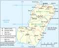 Island of Bioko.
 -
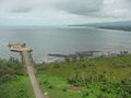 Coastline.
 -
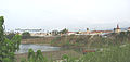 Waterfront.
 -
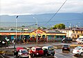 Mercado Central, Malabo City, Equatorial Guinea.


See also
References
- ^ "Malabo, Equatorial Guinea". Climate & Temperature. Retrieved August 13, 2012.
- ^ Cobb, Charles (16 December 2002). "Obiang Sure to Win As Opposition Quits Poll". AllAfrica.
- ^ "TECHNICAL SUPPORT PROJECT FOR SOCIAL INVESTMENT AND CAPACITY BUILDING IN EQUATORIAL GUINEA", Design and Implementation Plan, Contract No. DFD-I-00-05-0020 TO #2, (September 2006 through August 2008).
- ^ "Sister Cities, Public Relations". Guadalajara municipal government. Archived from the original on March 2, 2012. Retrieved March 12, 2013.
External links
3°45′N 8°47′E / 3.750°N 8.783°E
| International | |
|---|---|
| National | |
| Geographic | |
| Other | |