Tourism in Chile: Difference between revisions
No edit summary |
|||
| Line 1: | Line 1: | ||
{{dablinks|date=July 2015}} |
|||
[[File:Chile Travel - Promotional video.ogv|thumb|right|300px]] |
[[File:Chile Travel - Promotional video.ogv|thumb|right|300px]] |
||
[[File:Chile Travel- Isla de Pascua - Promotional video.ogv|thumb|300px|Promotional videos on tourism in [[Chile]] and [[Easter Island]] of [[National Tourism Service of Chile|Sernatur]].]] |
[[File:Chile Travel- Isla de Pascua - Promotional video.ogv|thumb|300px|Promotional videos on tourism in [[Chile]] and [[Easter Island]] of [[National Tourism Service of Chile|Sernatur]].]] |
||
Since the mid-1990s, the '''[[tourism]] in [[Chile]]''' has become one of the main economic resources of the country, especially in its most extreme areas. In 2005 this sector grew by 13.6%, generating more than 500 millions [[US dollar]]s, equivalent to 1.33% of national [[Gross Domestic Product|GDP]]. |
Since the mid-1990s, the '''[[tourism]] in [[Chile]]''' has become one of the main economic resources of the country, especially in its most extreme areas. In 2005 this sector grew by 13.6%, generating more than 500 millions [[US dollar]]s, equivalent to 1.33% of national [[Gross Domestic Product|GDP]]. |
||
According to the [[World Tourism Organization]] (WTO), Chile was the eighth popular destination for foreign tourists within America in 2010, after [[Tourism in the United States|USA]], [[Tourism in Mexico|Mexico]], [[Tourism in Canada|Canada]], [[Tourism in Argentina|Argentina]], [[Tourism in Brazil|Brazil]], [[Tourism in the Dominican Republic|Dominican Republic]] and [[Tourism in Puerto Rico|Puerto Rico]].<ref name=omt>{{cite book|author = [[World Tourism Organization]] (WTO)|URL = http://mkt.unwto.org/sites/all/files/docpdf/unwtohighlights11enlr_1.pdf |title=UNWTO Tourism Highlights 2011 Edition | format = PDF | accessdate = April 20, 2011 |year = 2010 |chapter = Regional Results: Americas | |
According to the [[World Tourism Organization]] (WTO), Chile was the eighth popular destination for foreign tourists within America in 2010, after [[Tourism in the United States|USA]], [[Tourism in Mexico|Mexico]], [[Tourism in Canada|Canada]], [[Tourism in Argentina|Argentina]], [[Tourism in Brazil|Brazil]], [[Tourism in the Dominican Republic|Dominican Republic]] and [[Tourism in Puerto Rico|Puerto Rico]].<ref name=omt>{{cite book|author = [[World Tourism Organization]] (WTO)|URL = http://mkt.unwto.org/sites/all/files/docpdf/unwtohighlights11enlr_1.pdf |title=UNWTO Tourism Highlights 2011 Edition | format = PDF | accessdate = April 20, 2011 |year = 2010 |chapter = Regional Results: Americas |pages = 8}}</ref> That year entered the country 2 766 000 tourists generated revenue of USD 1 636 million<ref name=wto/> The majority of these visitors came from American countries, mainly [[Argentina]]; however, the biggest growth in recent years has corresponded to visitors of [[Europe]], especially [[Germany]]<ref name=estadisticas2011>{{Cite web |url=http://www.sernatur.cl/institucional/scripts/estadisticas.php | title = Studies and statistics - Statistics - Arrivals of foreign tourists to Chile - By nationality: Foreign tourists entered by nationality, 2011 |language=Spanish | accessdate=June 19, 2012 | format=PHP | author = National Tourism Service ([[SERNATUR]]) | publisher = www.sernatur.cl}} {{dead link|date=July 2015}}</ref> During the first quarter of 2011, came more than 1 043 000 tourists, which represented an increase of 9,2 % over the same period last year,<ref>{{cite web | url = http://www.sernatur.cl/noticias/llegada-de-turistas-extranjeros-a-chile-aumenta-en-un-9 |title = Arrival of foreign tourists to Chile increased by 9% (in Spanish) |accessdate = April 8, 2011 |author = National Tourism Service (SERNATUR) |date = April 1, 2011 |publisher = www.sernatur.cl}}</ref> which became a total of 3 069 792 until the end of the year.<ref name=estadisticas2011 /> |
||
Located in the southwest corner of [[South America]], Chile it describes normally made up of three geographic areas.<ref name=ce2006/> The first one, known as [[continental Chile]], comprises a long and narrow strip of land on the west coast of [[Southern Cone]] that extends between the [[ |
Located in the southwest corner of [[South America]], Chile it describes normally made up of three geographic areas.<ref name=ce2006/> The first one, known as [[continental Chile]], comprises a long and narrow strip of land on the west coast of [[Southern Cone]] that extends between the [[parallel]]s 17°29'57" [[South|S]] and [[Diego Ramírez Islands|56°32'12" S]], mostly from the southeastern shore of the [[Pacific Ocean]] to the [[Andes]] throughout 4270 km <ref>{{cite book |title = Chile: A Country Study |accessdate = April 23, 2011 |year=1994 |publisher=Hudson, Rex A. | publisher=GPO for [[Library of Congress|The Library of Congress]] |location=Washington DC |isbn = |chapter=Geography |url=http://countrystudies.us/chile/36.htm |pages =}}</ref> The second, called [[insular Chile]], corresponds to a set of islands volcanic origin in the [[South Pacific Ocean]]: the [[Juan Fernández archipelago]] and [[Desventuradas Islands]], belonging to South America, the [[Isla Salas y Gómez|Salas y Gómez Island]] and [[Easter Island]] Geographically located in the [[Oceania|Polynesia]]. The third, called [[Chilean Antarctic Territory]],<ref name=d1747>{{cite web |url=http://www.leychile.cl/Navegar?idNorma=1017683&idVersion=1955-06-21 |title=Decree 1747, 1955 of the Ministry of Foreign Affairs |accessdate = March 20, 2011 |author=[[Ministry of Foreign Affairs of Chile|Ministry of Foreign Affairs]] |date = June 21, 1955}}</ref> is an area of the [[Antarctic]]a<ref name=dpd/> de 1 250 257,6 km² between [[meridian]]s 53° [[West|W]] and 90° W on which Chile claims [[sovereignty]], extending its southern boundary to the [[South Pole]]. Because of its presence in America, Oceania and Antarctica, Chile describes itself as a country [[tricontinentality of Chile|tricontinental]].<ref name=ce2006/><ref>{{cite web |url =http://www.gobiernodechile.cl/canal_regionalgeo_nacional_det.asp?id_geo=1 |title = National Geography: Location, size and extension (in Spanish)|accessdate = November 29, 2007 |format = ASP |author = [[President of Chile|Presidency of the Republic]], [[Ministry General Secretariat of Government of Chile|Ministry General Secretariat of Government]] (MSGG) |date = 2007 |publisher =www.gobiernodechile.cl}}</ref><ref>{{cite web |url=http://archive.wikiwix.com/cache/?url=http://www.icarito.cl/medio/articulo/0,0,38035857_152308993_152512596_1,00.html&title=Chile%3A%20un%20pa%C3%ADs%20tricontinental | title = Chile: A tri-continental country (in Spanish)|accessdate = March 29, 2008 |author = Icarito | publisher =www.icarito.cl}}</ref> |
||
The [[latitude|latitudinal]] width of the country, which spans over 39 [[Degree (angle)|degrees]], which reach more than 72 if include the Chilean Anthartic Territory-, its relief and influence of the Pacific Ocean are the main factors behind the [[Climate of Chile|climatic variety]] and landscape of Chile,<ref name=ce2006>{{cite web |url=http://www.ine.cl/canales/publicaciones/compendio_estadistico/pdf/2006/compendio2006.pdf |title=Statistical Compendium 2006 (in Spanish) |accessdate = November 29, 2007 |format = PDF |author = [[National Statistics Institute (Chile)]] (INE) |date=October 2006 |publisher=www.ine.cl}}</ref> which determines the development of the formation of different [[ecosystem]]s in the country. |
The [[latitude|latitudinal]] width of the country, which spans over 39 [[Degree (angle)|degrees]], which reach more than 72 if include the Chilean Anthartic Territory-, its relief and influence of the Pacific Ocean are the main factors behind the [[Climate of Chile|climatic variety]] and landscape of Chile,<ref name=ce2006>{{cite web |url=http://www.ine.cl/canales/publicaciones/compendio_estadistico/pdf/2006/compendio2006.pdf |title=Statistical Compendium 2006 (in Spanish) |accessdate = November 29, 2007 |format = PDF |author = [[National Statistics Institute (Chile)]] (INE) |date=October 2006 |publisher=www.ine.cl}}</ref> which determines the development of the formation of different [[ecosystem]]s in the country. |
||
The main Chilean [[tourist attraction|attractions]] correspond to its [[coast]] of 6435 km long,<ref name=coast>{{cite web |url==https://www.cia.gov/library/publications/the-world-factbook/fields/2060.html#ci |title = Coastline |accessdate = April 30, 2011 |author = Central Intelligence Agency (CIA) |date = 2011 |publisher = www .cia.gov }}</ref> the Andes, with its [[Ski resorts of Chile|ski resorts]], its [[List of mountains in Chile|mountains]] and [[List of volcanoes in Chile|volcanoes]] - [[List of islands of Chile|islands and archipelagos]] -Easter Island is one of the Chilean main attractions, and [[Protected areas of Chile|landscapes venues]] -integrated by 14 [[Natural Monuments of Chile|natural monuments]], 36 [[List of national parks of Chile|National Parks]], 10 biosphere reserves, 52 [[National Reserves of Chile|natural reserves]], 39 [[National Monuments of Chile#Sanctuaries of Nature|sanctuaries of Nature]] and 12 [[ |
The main Chilean [[tourist attraction|attractions]] correspond to its [[coast]] of 6435 km long,<ref name=coast>{{cite web |url==https://www.cia.gov/library/publications/the-world-factbook/fields/2060.html#ci |title = Coastline |accessdate = April 30, 2011 |author = Central Intelligence Agency (CIA) |date = 2011 |publisher = www .cia.gov }}</ref> the Andes, with its [[Ski resorts of Chile|ski resorts]], its [[List of mountains in Chile|mountains]] and [[List of volcanoes in Chile|volcanoes]] - [[List of islands of Chile|islands and archipelagos]] -Easter Island is one of the Chilean main attractions, and [[Protected areas of Chile|landscapes venues]] -integrated by 14 [[Natural Monuments of Chile|natural monuments]], 36 [[List of national parks of Chile|National Parks]], 10 biosphere reserves, 52 [[National Reserves of Chile|natural reserves]], 39 [[National Monuments of Chile#Sanctuaries of Nature|sanctuaries of Nature]] and 12 [[Ramsar sites in Chile|Ramsar sites]]-, mainly of the extreme parts of the country.<ref>{{cite web |url = http://www.lonelyplanet.com/chile |title = Destinations - South America - Chile: Overview |accessdate = June 16, 2012 |author = [[Lonely Planet]] |date = April 2, 2012 |publisher = www.lonelyplanet.com }}</ref> |
||
Among the ''[[souvenir]]s'' of Chile, include the [[Wine from Chile|wines]], work on copper and wood, textiles and crafts in general.<ref>{{book cite |title=Almanaque Mundial 1988 |language=Spanish |year = 1987 |last = Iglesias |first=Rafael | publisher = Editorial América S.A. |location = Panama |chapter = Chile - If you plan to visit Chile - Best Buys |pages = 252}}</ref> |
Among the ''[[souvenir]]s'' of Chile, include the [[Wine from Chile|wines]], work on copper and wood, textiles and crafts in general.<ref>{{book cite |title=Almanaque Mundial 1988 |language=Spanish |year = 1987 |last = Iglesias |first=Rafael | publisher = Editorial América S.A. |location = Panama |chapter = Chile - If you plan to visit Chile - Best Buys |pages = 252}}</ref> |
||
| Line 15: | Line 16: | ||
== Norte Grande == |
== Norte Grande == |
||
{{see also|Norte Grande, Chile}} |
{{see also|Norte Grande, Chile}} |
||
<gallery mode=packed caption=> |
|||
[[File:Parinacota volcano.jpg|thumb|left|[[Lauca National Park]]]] |
|||
File:Morroarica2011.JPG|[[Arica]] |
|||
| ⚫ | [[Atacama Desert]], the driest in the world <ref>{{cite web |url=http://www.dw-world.de/dw/article/0,2144,2250165,00.html | title = A plenty of sun, good is the water |accessdate=July 22, 2011 |author=Bolívar Manaut, Luna |date = November 27, 2006 |publisher =www.dw-world.de}}</ref> —in October 2014, the travel guide publisher [[Lonely Planet]] highlighted this desert as the ninth among the ten regions that had to go in 2015—;<ref>{{cite web |url=http://www.lonelyplanet.com/best-in-travel/regions/09-atacama-desert|title=Best in Travel 2015: Top 10 regions - 9. Atacama Desert |accessdate=January 13, 2015 |author=Lonely Planet |date=s/f |publisher=www.lonelyplanet.com}}</ref> which has been inhabited for several thousand years, makes up the main portion of [[Norte Grande, Chile|Norte Grande]]. A myriad of [[geoglyph]]s, [[petroglyph]]s and [[pictograph]]s attest the presence of ancient cultures in the area. Among the most remarkable are those of [[Azapa Valley]], [[Lluta River|Lluta Valley]], the [[Atacama Giant]] and Pintados Geoglyphs, these latter are protected within [[Pampa del Tamarugal National Reserve]]. [[R. P. Gustavo Le Paige Archaeological Museum]] and Archaeological Museum of San Miguel de Azapa are home to the most important collections of [[artifact (archaeology)|artifact]]s and mummies in Chile, including the famous [[Chinchorro mummies]], the oldest mummies in the world,<ref>{{publication cite |author=Bittman, B., y J. Munizaga |year = 1976 |title=The Earliest Artificial Mummification in the World? A Study of the Chinchorro Complex in Northern Chile |publisher=Folk |location = |volume = |number = 18 |pages = 61-92 |accessdate=May 26, 2011}}</ref> of [[Chinchorro culture]] developed between 5000 and 1700. C. The extreme aridity of the Atacama has been a key factor in the preservation of such archaeological remains. the [[Chuquicamata]] copper deposit, the largest [[open pit mine]] in the world;.<ref>{{cite web |url=http://www.codelco.com/prontus_codelco/site/edic/base/port/chuquicamata.html | title=Operations - Chuquicamata |accessdate=November 22, 2011 |author=[[Codelco]] |date=s/f |publisher=www.codelco.com}}</ref> And the remains of extractions made from 12,000 and 10,000 years ago in a [[SR15 Mine|mine]] of [[iron oxide]], the oldest mine on the continent.<ref>{{cite web |url=http://papeldigital.info/lt/?2011052001# | title=Study confirms oldest mine in America was in Taltal (in Spanish) |accessdate = May 21, 2011 |author =Rodríguez, F. |date = May 20, 2011 |publisher=''[[La Tercera]]'' | |
||
File:Iquique.JPG|[[Iquique]] |
|||
File:Antofagasta playa el carboncillo.jpg|[[Antofagasta]] |
|||
File:The_Giant_of_Atacama.jpg|The [[Atacama Giant]] |
|||
File:MomiaChinchorro.jpg|[[Chinchorro mummies]] |
|||
</gallery> |
|||
| ⚫ | [[Atacama Desert]], the [[Dryness|driest]] in the world <ref>{{cite web |url=http://www.dw-world.de/dw/article/0,2144,2250165,00.html | title = A plenty of sun, good is the water |accessdate=July 22, 2011 |author=Bolívar Manaut, Luna |date = November 27, 2006 |publisher =www.dw-world.de}}</ref> —in October 2014, the travel guide publisher [[Lonely Planet]] highlighted this desert as the ninth among the ten regions that had to go in 2015—;<ref>{{cite web |url=http://www.lonelyplanet.com/best-in-travel/regions/09-atacama-desert|title=Best in Travel 2015: Top 10 regions - 9. Atacama Desert |accessdate=January 13, 2015 |author=Lonely Planet |date=s/f |publisher=www.lonelyplanet.com}}</ref> which has been inhabited for several thousand years, makes up the main portion of [[Norte Grande, Chile|Norte Grande]]. A myriad of [[geoglyph]]s, [[petroglyph]]s and [[pictograph]]s attest the presence of ancient cultures in the area. Among the most remarkable are those of [[Azapa Valley]], [[Lluta River|Lluta Valley]], the [[Atacama Giant]] and Pintados Geoglyphs, these latter are protected within [[Pampa del Tamarugal National Reserve]]. [[R. P. Gustavo Le Paige Archaeological Museum]] and Archaeological Museum of San Miguel de Azapa are home to the most important collections of [[artifact (archaeology)|artifact]]s and mummies in Chile, including the famous [[Chinchorro mummies]], the oldest mummies in the world,<ref>{{publication cite |author=Bittman, B., y J. Munizaga |year = 1976 |title=The Earliest Artificial Mummification in the World? A Study of the Chinchorro Complex in Northern Chile |publisher=Folk |location = |volume = |number = 18 |pages = 61-92 |accessdate=May 26, 2011}}</ref> of [[Chinchorro culture]] developed between 5000 and 1700. C. The extreme aridity of the Atacama has been a key factor in the preservation of such archaeological remains. the [[Chuquicamata]] copper deposit, the largest [[open pit mine]] in the world;.<ref>{{cite web |url=http://www.codelco.com/prontus_codelco/site/edic/base/port/chuquicamata.html | title=Operations - Chuquicamata |accessdate=November 22, 2011 |author=[[Codelco]] |date=s/f |publisher=www.codelco.com}}</ref> And the remains of extractions made from 12,000 and 10,000 years ago in a [[SR15 Mine|mine]] of [[iron oxide]], the oldest mine on the continent.<ref>{{cite web |url=http://papeldigital.info/lt/?2011052001# | title=Study confirms oldest mine in America was in Taltal (in Spanish) |accessdate = May 21, 2011 |author =Rodríguez, F. |date = May 20, 2011 |publisher=''[[La Tercera]]'' |pages=52}}</ref><ref>{{cite web |url==http://www.sciencenewsline.com/archaeology/2011052013000004.html |title = Archaeologists uncover oldest mine in the Americas |accessdate=May 21, 2011 |author=University of Chicago Press Journals |date = May 20, 2011 |publisher = ScienceNewsline}}</ref> |
||
[[Arica, Chile|Arica]] is a coastal city with beautiful beaches and is also a starting point for travelers heading east to [[Putre]] for enjoying the majestic [[Central Andean dry puna|Puna]] landscape of [[Lauca National Park]]. Southward from Lauca, [[Volcán Isluga National Park]] includes ceremonial sites for the [[Aymara people|Aymara]] people. |
[[Arica, Chile|Arica]] is a coastal city with beautiful beaches and is also a starting point for travelers heading east to [[Putre]] for enjoying the majestic [[Central Andean dry puna|Puna]] landscape of [[Lauca National Park]]. Southward from Lauca, [[Volcán Isluga National Park]] includes ceremonial sites for the [[Aymara people|Aymara]] people. |
||
[[File:MonumentoNaturalLaPortada.jpg|thumb|right|[[La Portada]] Natural Monument]] |
|||
Inland from [[Iquique]], the desolate pampas are home to a few scattered towns and villages. Among those, the most interesting is the ghost town of [[Humberstone and Santa Laura Saltpeter Works|Humberstone]], declared [[World Heritage]] by [[UNESCO]] in 2005. In this area the [[tamarugo]] forests of the [[Pampa del Tamarugal]] break the barren monotony of the landscape. |
Inland from [[Iquique]], the desolate pampas are home to a few scattered towns and villages. Among those, the most interesting is the ghost town of [[Humberstone and Santa Laura Saltpeter Works|Humberstone]], declared [[World Heritage]] by [[UNESCO]] in 2005. In this area the [[tamarugo]] forests of the [[Pampa del Tamarugal]] break the barren monotony of the landscape. |
||
[[File:Yepun and the Milky Way.jpg|thumb|left|[[Paranal Observatory]], at an altitude of 2635 meters above sea level, is the world's most advanced ground-based astronomical observatory.<ref>{{cite web|title=Yepun and the Milky Way|url=http://www.eso.org/public/images/potw1525a/|accessdate=22 June 2015}}</ref>]] |
|||
The altiplano of Norte Grande has a wide variety of natural scenery including salt flats, volcanoes, lakes and geysers. [[San Pedro de Atacama]] and surrounding area offer one of most spectacular combinations of archeology and awe-inspiring natural sights. San Pedro was the cradle of the [[Atacameño]] Culture. Villages with interesting cultural past are [[Caspana]], [[Toconao]], [[Socaire]] and [[Chiu Chiu]]. Notable are also the pre-Hispanic fortresses of [[Quitor]], [[Lasana]] and Turi. |
The altiplano of Norte Grande has a wide variety of natural scenery including salt flats, volcanoes, lakes and geysers. [[San Pedro de Atacama]] and surrounding area offer one of most spectacular combinations of archeology and awe-inspiring natural sights. San Pedro was the cradle of the [[Atacameño]] Culture. Villages with interesting cultural past are [[Caspana]], [[Toconao]], [[Socaire]] and [[Chiu Chiu]]. Notable are also the pre-Hispanic fortresses of [[Quitor]], [[Lasana]] and Turi. |
||
[[Antofagasta]] is the largest city in Norte Grande. [[La Portada]], a stunning [[natural arch]], is located a short drive from Antofagasta. |
[[Antofagasta]] is the largest city in Norte Grande. [[La Portada]], a stunning [[natural arch]], is located a short drive from Antofagasta. |
||
| Line 28: | Line 34: | ||
[[Pan de Azúcar National Park]] is a park where sea and desert meet. |
[[Pan de Azúcar National Park]] is a park where sea and desert meet. |
||
Also, [[Astronomy in Chile|there more than a dozen of astronomical facilities]], including optical observatories and radio observatories. Among others, the most important are: [[Paranal Observatory|Paranal]] ([[Very Large Telescope|VLT]]), the most advanced and powerful astronomical |
Also, [[Astronomy in Chile|there more than a dozen of astronomical facilities]], including optical observatories and radio observatories. Among others, the most important are: [[Paranal Observatory|Paranal]] ([[Very Large Telescope|VLT]]), at an altitude of 2635 meters above sea level, is the world's most advanced and powerful astronomical observatory.<ref>{{cite web|title=Yepun and the Milky Way|url=http://www.eso.org/public/images/potw1525a/|accessdate=22 June 2015}}</ref> the ALMA ([[Atacama Large Millimeter Array]]), to date the largest astronomical project in the world;<ref>{{cite web |url=http://www.eso.cl/alma.php |title=ALMA (in Spanish)|accessdate=December 4, 2011 |format = PHP |author = European Southern Observatory (ESO) |date=s/f |publisher=www.eso.cl}}</ref><ref>{{cite web |url=http://www.almaobservatory.org/es/inicio |title=Atacama Large Millimeter/submillimeter Array |accessdate=December 4, 2011 |author = ALMA |date=s/f |publisher=www.almaobservatory.org}}</ref> and [[La Silla Observatory|La Silla]],<ref>{{cite web |url=http://www.eso.cl/lasilla.php |title=La Silla Observatory (in Spanish) |accessdate=December 4, 2011 |format = PHP |author=European Southern Observatory (ESO) |date=s/f |publisher=www.eso.cl}}</ref> all dependent of ESO ([[European Southern Observatory]]). |
||
In this area, it can see the [[flowering desert]], a phenomenon that occurs between September and November (most in last years) with normal range rainfall in the desert.<ref>{{cite web |url=http://www.lasegunda.com/Noticias/Nacional/2011/11/695014/El-desierto-de-Atacama-florece-como-nunca-en-los-ultimos-20-anos |title=The Atacama desert flourishes as never in the past 20 years (in Spanish) |accessdate = June 22, 2013 |author=[[Agence France-Presse]] |date=November 7, 2011 |publisher=www.lasegunda,com}}</ref> In the end of the Norte Grande, near [[Putre]], it can see the set formed by the [[Chungará Lake|Lake Chungará]], one of the highest lakes in the world with 4500 [[m]],<ref>{{cite web |url=http://www.highestlake.com/highest-lake-world.html |title=The Highest Lake in the World |accessdate = June 11, 2012 |author=Drews, Carl |date = August 20, 2010 |publisher=www.highestlake.com}}</ref> and [[Parinacota (volcano)|Parinacota volcano]]. [[San Pedro de Atacama]] is very visited by foreign tourists to appreciate the architecture of the town, the highland lakes the [[Valle de la Luna (Chile)|Moon Valley]], so-named because its landscape resembles the moon. |
In this area, it can see the [[flowering desert]], a phenomenon that occurs between September and November (most in last years) with normal range rainfall in the desert.<ref>{{cite web |url=http://www.lasegunda.com/Noticias/Nacional/2011/11/695014/El-desierto-de-Atacama-florece-como-nunca-en-los-ultimos-20-anos |title=The Atacama desert flourishes as never in the past 20 years (in Spanish) |accessdate = June 22, 2013 |author=[[Agence France-Presse]] |date=November 7, 2011 |publisher=www.lasegunda,com}}</ref> In the end of the Norte Grande, near [[Putre]], it can see the set formed by the [[Chungará Lake|Lake Chungará]], one of the highest lakes in the world with 4500 [[m]],<ref>{{cite web |url=http://www.highestlake.com/highest-lake-world.html |title=The Highest Lake in the World |accessdate = June 11, 2012 |author=Drews, Carl |date = August 20, 2010 |publisher=www.highestlake.com}}</ref> and [[Parinacota (volcano)|Parinacota volcano]]. [[San Pedro de Atacama]] is very visited by foreign tourists to appreciate the architecture of the town, the highland lakes the [[Valle de la Luna (Chile)|Moon Valley]], so-named because its landscape resembles the moon. |
||
The coastal resorts of the area Norte Grande like [[Arica]], [[Iquique]], [[Antofagasta]]- host to the national tourism during the summer months. |
The coastal resorts of the area Norte Grande like [[Arica]], [[Iquique]], [[Antofagasta]]- host to the national tourism during the summer months. |
||
<gallery mode=packed caption=> |
|||
File:Parinacota volcano 1995.jpg|[[Lake Chungará]] and [[Parinacota volcano]] |
|||
File:AtacamValley.jpg|Valle de Atacama |
|||
File:SanPedroAtacama-001.jpg|[[San Pedro de Atacama]] |
|||
File:Salar de Atacama.jpg|[[Salar de Atacama]] in the [[Atacama Desert]] |
|||
File:Moonset over ESO's Very Large Telescope.jpg|[[Very Large Telescope]] (VLT), [[Paranal Observatory]] |
|||
</gallery> |
|||
== Norte Chico == |
== Norte Chico == |
||
{{see also|Norte Chico, Chile}} |
{{see also|Norte Chico, Chile}} |
||
[[File:Valle del Elqui, La Serena-Chile.JPG|thumb|right|[[Elqui Valley (wine region)|Elqui Valley]]]] |
|||
The Andes of [[Norte Chico, Chile|Norte Chico]] are home to many of the highest volcanoes in the world, the highlight being the [[Ojos del Salado]] of 6891.3 [[m]], the world´s highest [[volcano]] and the highest peak in Chile<ref>{{cite web |url=http://www.los6000dechile.cl/pdf/bch_cumbres_21_ojosdelsalado.pdf |title = Ojos del Salado -Cara Norte/North Face |accessdate = March 9, 2011 |format = PDF |date= s/f |publisher=www.los6000dechile.cl |language=Spanish and English}}</ref> -the second of the continent and [[Southern Hemisphere|Southern]] and [[Western Hemisphere|Western]] hemisphere-.<ref>{{cite web |url=http://desnivel.com/deportes/alpinismo/object.php?o=15835 |title=Ojos del Salado, the highest volcano in the world (in Spanish) |accessdate=July 20, 2008 |format = PHP |author=Turrel, Marc, and Jorge Velasco |date = May 18, 2007 |publisher=desnivel.com}}</ref> Apart from Ojos del Salado and the rest of the volcanoes, attractions in this portion of the Andes include [[Nevado Tres Cruces National Park]] and [[Laguna Verde (lake of Chile)|Laguna Verde]]. |
The Andes of [[Norte Chico, Chile|Norte Chico]] are home to many of the highest volcanoes in the world, the highlight being the [[Ojos del Salado]] of 6891.3 [[m]], the world´s highest [[volcano]] and the highest peak in Chile<ref>{{cite web |url=http://www.los6000dechile.cl/pdf/bch_cumbres_21_ojosdelsalado.pdf |title = Ojos del Salado -Cara Norte/North Face |accessdate = March 9, 2011 |format = PDF |date= s/f |publisher=www.los6000dechile.cl |language=Spanish and English}}</ref> -the second of the continent and [[Southern Hemisphere|Southern]] and [[Western Hemisphere|Western]] hemisphere-.<ref>{{cite web |url=http://desnivel.com/deportes/alpinismo/object.php?o=15835 |title=Ojos del Salado, the highest volcano in the world (in Spanish) |accessdate=July 20, 2008 |format = PHP |author=Turrel, Marc, and Jorge Velasco |date = May 18, 2007 |publisher=desnivel.com}}</ref> Apart from Ojos del Salado and the rest of the volcanoes, attractions in this portion of the Andes include [[Nevado Tres Cruces National Park]] and [[Laguna Verde (lake of Chile)|Laguna Verde]]. |
||
| Line 43: | Line 55: | ||
The clear skies of Norte Chico and its world-renowned infrastructure have made it ideal for astronomical tourism{{Citation needed|date=February 2012}}. |
The clear skies of Norte Chico and its world-renowned infrastructure have made it ideal for astronomical tourism{{Citation needed|date=February 2012}}. |
||
[[Elqui Valley (wine region)|Elqui Valley]] is a very popular destination. In January 2015, the travel section of ''[[The New York Times]]'' said the Elqui Valley as the 5th of the 52 places it had to visit in 2015.<ref>{{cite |
[[Elqui Valley (wine region)|Elqui Valley]] is a very popular destination. In January 2015, the travel section of ''[[The New York Times]]'' said the [[Elqui Valley]] as the 5th of the 52 places it had to visit in 2015.<ref>{{cite web |url=http://www.nytimes.com/interactive/2015/01/11/travel/52-places-to-go-in-2015.html |title=52 Places to Go in 2015 - 5. Elqui Valley, Chile |accessdate = January 13, 2015 |author=''[[The New York Times]]'' |date = January 9, 2015 |publisher=www.nytimes.com}}</ref> Here, the dazzling green of the valley floor contrasts nicely with the barren brown slopes of the mountains that flank it. |
||
Here it found [[El Tatio]] [[Geyser]] Field, the largest [[geyser]] fields in the [[Southern Hemisphere]] and the third in the world.<ref>{{cite web |url=http://www.alanglennon.com/travel/tatio.htm |title=The extraordinary thermal activity of El Tatio Geyser Field, Antofagasta Region, Chile |accessdate = November 27, 2013 |author=Glennon, J. A., y R. M. Pfaff |publisher=www.alanglennon.com}}</ref> |
Here it found [[El Tatio]] [[Geyser]] Field, the largest [[geyser]] fields in the [[Southern Hemisphere]] and the third in the world.<ref>{{cite web |url=http://www.alanglennon.com/travel/tatio.htm |title=The extraordinary thermal activity of El Tatio Geyser Field, Antofagasta Region, Chile |accessdate = November 27, 2013 |author=Glennon, J. A., y R. M. Pfaff |publisher=www.alanglennon.com}}</ref> |
||
The [[syncretism]] between [[ |
The [[syncretism]] between [[Aymara]] tradition and [[Catholicism]] it has produced festivals and religious traditions -such as those dedicated to [[Virgin del Carmen de Chile|Virgen del Carmen]] in [[La Tirana]] and to [[Our Lady of Andacollo|Virgin]] of [[Andacollo]]- and [[carnival]]s. The [[Baile chino]], one of the manifestations of religious fervor, was declared [[Intangible Cultural Heritage]] by UNESCO in 2014.<ref>{{cite web |url=http://www.unesco.org/culture/ich/index.php?lg=en&pg=00011&RL=00988 |title=Intangible Cultural Heritage - Chile: Baile Chino |accessdate = June 1, 2015 |format = PHP |author = United Nations Educational , Scientific and Cultural Organization (UNESCO) |date = 2014 |publisher = www.unesco.org }}</ref> |
||
<gallery mode=packed caption=> |
|||
File:La Serena-Coquimbo-02.jpg|[[La Serena (Chile)|La Serena]] |
|||
File:Copiapó, atardecer de Otoño.jpg|[[Copiapó]] |
|||
File:Ojos del Salado 2004a.jpg|[[Ojos del Salado]] volcano |
|||
File:Valle_del_Elqui,_La_Serena-Chile.JPG|[[Elqui Valley]], wine and pisco region |
|||
File:Chile-Tatio-Geyser.jpg|[[El Tatio]] geyser fields |
|||
</gallery> |
|||
== Zona Central == |
== Zona Central == |
||
{{see also|Zona Central, Chile}} |
{{see also|Zona Central, Chile}} |
||
<gallery mode=packed caption=> |
|||
| ⚫ | |||
File:Casona Artillería Nº 156.JPG|[[Valparaíso]] |
|||
File:Santiago en invierno.jpg|[[Santiago, Chile|Santiago]] |
|||
File:Plaza de Los Héroes.JPG|[[Rancagua]] |
|||
File:Esquinaplaza.JPEG|[[Talca]] |
|||
File:Concepcion-Chile(001).jpg|[[Concepción, Chile|Concepción]] |
|||
</gallery> |
|||
This area is home to the main ski resorts in Chile, which attract a significant number of tourists from the northern hemisphere because the reversed [[alpine skiing]] season. They are Chapa Verde, [[Portillo, Chile|Portillo]], [[Valle Nevado]] and [[Termas de Chillán]]. Furthermore, [[Wine tourism]] is common in [[Zona Central, Chile|Zona Central]], and the Wine Routes of the [[Casablanca, Chile|Casablanca]], [[Cachapoal Valley|Cachapoal]] and [[Colchagua Valley|Colchagua]] valleys are some of the finest in Chile. |
This area is home to the main ski resorts in Chile, which attract a significant number of tourists from the northern hemisphere because the reversed [[alpine skiing]] season. They are Chapa Verde, [[Portillo, Chile|Portillo]], [[Valle Nevado]] and [[Termas de Chillán]]. Furthermore, [[Wine tourism]] is common in [[Zona Central, Chile|Zona Central]], and the Wine Routes of the [[Casablanca, Chile|Casablanca]], [[Cachapoal Valley|Cachapoal]] and [[Colchagua Valley|Colchagua]] valleys are some of the finest in Chile. |
||
| Line 57: | Line 83: | ||
Apart from the national capital itself and its many attractions, the metropolitan region surrounding [[Santiago, Chile|Santiago]] includes several attractions such as the [[Cajón del Maipo]], [[Pomaire]], and some of the oldest vineyards in the country, as well as various archaeological sites.<ref>{{cite web|title=Arqueologia.cl|url=http://www.arqueologia.cl|publisher=Arqueologia.cl|accessdate=2 November 2012}}</ref> |
Apart from the national capital itself and its many attractions, the metropolitan region surrounding [[Santiago, Chile|Santiago]] includes several attractions such as the [[Cajón del Maipo]], [[Pomaire]], and some of the oldest vineyards in the country, as well as various archaeological sites.<ref>{{cite web|title=Arqueologia.cl|url=http://www.arqueologia.cl|publisher=Arqueologia.cl|accessdate=2 November 2012}}</ref> |
||
Due to its proximity to the capital, the coast of the [[Valparaiso Region]] is that during the summer months it has the largest number of tourists, primarily in the central coast and [[Viña del Mar]]. The latter city is considered the ''tourist capital of Chile''<ref>{{cite web |url=http://www.visitevinadelmar.cl/web/ |title=Inicio - Our city Viña del Mar |accessdate=May 7, 2012 |date = s / f |publisher=www.visitevinadelmar.cl}}</ref> for its importance in the area thanks to its thirteen [[beach]]s,<ref name=vvm/> its various entertainment centers -has [[Viña del Mar Casino|one of major casinos]] of the country-,<ref>{{cite web |url=http://www.chile.com/secciones/ver_seccion.php?id=96759 |title = Crossing Chile - Meet the Viña del Mar Casino (in Spanish) |accessdate=May 7, 2012 |format = PHP |author=Pizarro R., Karen |date=s/f |publisher=www.chile.com}}</ref> and the [[International Song Festival of Viña del Mar]], -the largest and best-known festival of [[Latin America]], and considered the main of [[ |
Due to its proximity to the capital, the coast of the [[Valparaiso Region]] is that during the summer months it has the largest number of tourists, primarily in the [[central coast]] and [[Viña del Mar]]. The latter city is considered the ''tourist capital of Chile''<ref>{{cite web |url=http://www.visitevinadelmar.cl/web/ |title=Inicio - Our city Viña del Mar |accessdate=May 7, 2012 |date = s / f |publisher=www.visitevinadelmar.cl}}</ref> for its importance in the area thanks to its thirteen [[beach]]s,<ref name=vvm/> its various entertainment centers -has [[Viña del Mar Casino|one of major casinos]] of the country-,<ref>{{cite web |url=http://www.chile.com/secciones/ver_seccion.php?id=96759 |title = Crossing Chile - Meet the Viña del Mar Casino (in Spanish) |accessdate=May 7, 2012 |format = PHP |author=Pizarro R., Karen |date=s/f |publisher=www.chile.com}}</ref> and the [[International Song Festival of Viña del Mar]], -the largest and best-known festival of [[Latin America]], and considered the main of [[América|American continent]].-.<ref>{{publication cite |author = Fortuño, Sergio |date=January 26, 2002 |title=Latin - Stage Is Set For Viña Del Mar |language=English |publication=[[Billboard]] |pages = 41 |cite=[...] the best-known music festival in Latin America}}</ref><ref>{{cite web |url=http://www.esctoday.com/45797/iceland-hera-bjork-in-the-final-of-vina-del-mar-international-song-contest-2013/ |title=Iceland: Hera Björk in the final of Viña del Mar International Song Contest 2013 |accessdate=March 7, 2013 |author=Floras, Stella |date =February 18, 2013 |publisher=www.esctoday.com |quote=[T]he Viña del Mar International Song Contest [is] the oldest and biggest music festival in Latin America}}</ref><ref>{{cite web |url=http://mexico.cnn.com/entretenimiento/2010/02/23/paul-anka-cerro-con-gran-exito-la-primera-jornada-de-vina-del-mar |title=Paul Anka ended with great success, the first day of Viña del Mar (in Spanish) |accessdate = May 27, 2013 |author=CNN México |date = February 23, 2010 |publisher=mexico.cnn.com |quote = The International Song Festival of Viña del Mar is the most important musical event of the continent}}</ref> |
||
[[Valparaíso]] is a wonderful, amphitheater-shaped city, whose historic quarter has been recognized as a [[World Heritage Site]]. |
[[Valparaíso]] is a wonderful, amphitheater-shaped city, whose historic quarter has been recognized as a [[World Heritage Site]]. |
||
[[Santiago, Chile|Santiago]], the capital and main urban center of Chile, home to many historic sites and heritage. Within the [[Greater Santiago]], there are 174 [[National Monuments of Chile|heritage sites]] under the custody of [[Nationals Monuments Council]] (CMN),<ref>[[Nationals Monuments Council]] ( CMN). Search of monuments in the provinces of [http://www.monumentos.cl/resultado_busqueda.php?seccion=Monumentos&avanzada=S¶metro=®ion_id=13&provincia_id=51&comuna_id=0&categoria_id=0&tipo_id=0&bot_buscar_avanzada.x=24&bot_buscar_avanzada.y=11 Santiago] and [http://www.monumentos.cl/resultado_busqueda.php?seccion=Monumentos&avanzada=S¶metro=®ion_id=13&provincia_id=47&comuna_id=0&categoria_id=0&tipo_id=0&bot_buscar_avanzada.x=37&bot_buscar_avanzada.y=16 Cordillera] and the commune of [http://www.monumentos.cl/resultado_busqueda.php?seccion=Monumentos&avanzada=S¶metro=®ion_id=13&provincia_id=48&comuna_id=290&categoria_id=0&tipo_id=0&bot_buscar_avanzada.x=56&bot_buscar_avanzada.y=18 San Bernardo]. URL accessed on December 23, 2007</ref> among which are archaeological, architectural and historical monuments, in addition to typical or picturesque areas. Of these, 93 are located within the [[Santiago (commune)|commune of Santiago]], considered the ''historic center'' of the city<ref>{{cite web |url=http://www.monumentos.cl/resultado_busqueda.php?seccion=Monumentos&avanzada=S¶metro=®ion_id=13&provincia_id=51&comuna_id=303&categoria_id=0&tipo_id=0&bot_buscar_avanzada.x=52&bot_buscar_avanzada.y=4 |title = Monuments of the commune of Santiago |accessdate = December 23, 2007 |author = Nationals Monuments Council (CMN) |date =s/f |publisher = www.monumentos.cl}}</ref> Although no Santiagan monument was even declared [[World Heritage]] by [[UNESCO]], three have already been proposed by the Chilean government: the Incan sanctuary [[cerro El Plomo]], the [[San Francisco Church, Santiago de Chile|church and convent of San Francisco]] and [[La Moneda Palace|Palace of La Moneda]]<ref>{{cite web | url=http://whc.unesco.org/en/tentativelists/state=cl |title=Tentative Lists: Chile |accessdate = December 23, 2007 |author = [[United Nations Educational, Scientific and Cultural Organization]] (UNESCO) |date=February 23, 2004 |publisher=whc.unesco.org}}</ref> Meanwhile, in June 2012, the magazine ''[[ |
[[Santiago, Chile|Santiago]], the capital and main urban center of Chile, home to many historic sites and heritage. Within the [[Greater Santiago]], there are 174 [[National Monuments of Chile|heritage sites]] under the custody of [[Nationals Monuments Council]] (CMN),<ref>[[Nationals Monuments Council]] ( CMN). Search of monuments in the provinces of [http://www.monumentos.cl/resultado_busqueda.php?seccion=Monumentos&avanzada=S¶metro=®ion_id=13&provincia_id=51&comuna_id=0&categoria_id=0&tipo_id=0&bot_buscar_avanzada.x=24&bot_buscar_avanzada.y=11 Santiago] and [http://www.monumentos.cl/resultado_busqueda.php?seccion=Monumentos&avanzada=S¶metro=®ion_id=13&provincia_id=47&comuna_id=0&categoria_id=0&tipo_id=0&bot_buscar_avanzada.x=37&bot_buscar_avanzada.y=16 Cordillera] and the commune of [http://www.monumentos.cl/resultado_busqueda.php?seccion=Monumentos&avanzada=S¶metro=®ion_id=13&provincia_id=48&comuna_id=290&categoria_id=0&tipo_id=0&bot_buscar_avanzada.x=56&bot_buscar_avanzada.y=18 San Bernardo]. URL accessed on December 23, 2007</ref> among which are archaeological, architectural and historical monuments, in addition to [[Typical Zone|typical or picturesque areas]]. Of these, 93 are located within the [[Santiago (commune)|commune of Santiago]], considered the ''historic center'' of the city<ref>{{cite web |url=http://www.monumentos.cl/resultado_busqueda.php?seccion=Monumentos&avanzada=S¶metro=®ion_id=13&provincia_id=51&comuna_id=303&categoria_id=0&tipo_id=0&bot_buscar_avanzada.x=52&bot_buscar_avanzada.y=4 |title = Monuments of the commune of Santiago |accessdate = December 23, 2007 |format = |author = Nationals Monuments Council (CMN) |date =s/f |publisher = www.monumentos.cl}}</ref> Although no Santiagan monument was even declared [[World Heritage]] by [[UNESCO]], three have already been proposed by the Chilean government: the Incan sanctuary [[cerro El Plomo]], the [[San Francisco Church, Santiago de Chile|church and convent of San Francisco]] and [[La Moneda Palace|Palace of La Moneda]]<ref>{{cite web | url=http://whc.unesco.org/en/tentativelists/state=cl |title=Tentative Lists: Chile |accessdate = December 23, 2007 |format = |author = [[United Nations Educational, Scientific and Cultural Organization]] (UNESCO) |date=February 23, 2004 |publisher=whc.unesco.org}}</ref> Meanwhile, in June 2012, the magazine ''[[National Geographic]]'' said the [[Mercado Central de Santiago|Central Market of Santiago]] as the fifth best in the world<ref>{{cite web |url=http://travel.nationalgeographic.com/travel/top-10/food-markets/#page=1 |title=Top 10 Food Markets |accessdate=June 11, 2012 |author=''[[National Geographic]]'' |date = s/f |publisher=travel.nationalgeographic.com}}</ref> In January 2011 The travel section of ''The New York Times'' said the city of Santiago as the first of the 41 places it had to visit that year,<ref>{{cite web |url=http://travel.nytimes.com/2011/01/09/travel/09where-to-go.html?ref=travel |title=The 41 Places to Go in 2011 - 1. Santiago, Chile |accessdate=June 10, 2012 |author=''The New York Times'' |date=January 7, 2011 |publisher = travel.nytimes.com}}</ref> while the site specializing in tourism [[TripAdvisor]] considered it the sixth best destination of [[South America]] in 2012.<ref name=tacom>{{cite web |url=http://www.tripadvisor.com/TravelersChoice-Destinations-cTop-g13 |title=Top 25 Destinations in South America |accessdate=June 13, 2012 |author= |date = 2012 |publisher=www.tripadvisor.com}}</ref> |
||
The O'Higgins Region, south of Santiago, is known as "[[Huaso]] country" for its rural ''[[Criollo people|criollo]]'' culture.<ref>{{cite web|title=About Chile & It's People|url=http://www.ohigginstours.com/information|publisher=O'Higgins Tours|accessdate=2 November 2012}}</ref> [[Pichilemu]], in the O'Higgins Region, is reputed to have the best beaches for [[Surfing in Chile]], if not the world.<ref>{{cite web|title=Pichilemu|url=http://www.turismolibertador.cl/en/site/where-go-region-ohiggins/zone-COAST/district-Pichilemu/|publisher=TurismoLibertador|accessdate=2 November 2012}}</ref> Other tourist sites in the O'Higgins region include the historically significant city of [[Rancagua]], and the [[Río de Los Cipreses National Reserve|Rio de los Cipreses nature reserve.]] |
The O'Higgins Region, south of Santiago, is known as "[[Huaso]] country" for its rural ''[[Criollo people|criollo]]'' culture.<ref>{{cite web|title=About Chile & It's People|url=http://www.ohigginstours.com/information|publisher=O'Higgins Tours|accessdate=2 November 2012}}</ref> [[Pichilemu]], in the O'Higgins Region, is reputed to have the best beaches for [[Surfing in Chile]], if not the world.<ref>{{cite web|title=Pichilemu|url=http://www.turismolibertador.cl/en/site/where-go-region-ohiggins/zone-COAST/district-Pichilemu/|publisher=TurismoLibertador|accessdate=2 November 2012}}</ref> Other tourist sites in the O'Higgins region include the historically significant city of [[Rancagua]], and the [[Río de Los Cipreses National Reserve|Rio de los Cipreses nature reserve.]] |
||
| Line 68: | Line 94: | ||
Further south in the Maule and Bio Bio regions are the [[Radal Siete Tazas National Reserve]] and [[Laguna del Laja National Park]]. |
Further south in the Maule and Bio Bio regions are the [[Radal Siete Tazas National Reserve]] and [[Laguna del Laja National Park]]. |
||
<gallery mode=packed caption=> |
|||
| ⚫ | |||
File:Cerrosantalucia.jpg|[[Cerro Santa Lucía]] |
|||
File:Museo Colchagua Santa Cruz.jpg|[[Colchagua Museum]] |
|||
File:Viñedo Puente Alto.jpg|Vineyard near the [[Andes]] |
|||
File:Salto del Laja 1.jpg|[[Laja Falls]] |
|||
</gallery> |
|||
== Zona Sur == |
== Zona Sur == |
||
{{see also|Zona Sur}} |
{{see also|Zona Sur}} |
||
[[File:Pucon.JPG|thumb|left|Volcano and [[Lake Villarrica]] in Pucón]] |
|||
[[Araucanía Region]] is the heartland of the [[Mapuche]] people. This area exhibits an incipient development of Indigenous tourism, in different sectors. in the coastal area of Araucania Ethnological tourism is developed on the banks Mapuche [[Budi Lake]]. |
[[Araucanía Region]] is the heartland of the [[Mapuche]] people. This area exhibits an incipient development of Indigenous tourism, in different sectors. in the coastal area of Araucania Ethnological tourism is developed on the banks Mapuche [[Budi Lake]]. |
||
| Line 80: | Line 112: | ||
The capital of Araucania is [[Temuco]], city of different service, hotels, tourist circuits, airport, markets, and the symbolic and historic sectors, the [[Cerro Ñielol Natural Monument]] is an icon of this city, and the most important tourist point. |
The capital of Araucania is [[Temuco]], city of different service, hotels, tourist circuits, airport, markets, and the symbolic and historic sectors, the [[Cerro Ñielol Natural Monument]] is an icon of this city, and the most important tourist point. |
||
[[File:Valdivia.jpg|thumb|right|[[Valdivia]]]] |
|||
[[Valdivia, Chile|Valdivia]] is one of Chile's most beautiful cities, recognition received mainly because of its lush natural surrounding. South from the city lies the colonial [[Valdivian Fort System]]. |
[[Valdivia, Chile|Valdivia]] is one of Chile's most beautiful cities, recognition received mainly because of its lush natural surrounding. South from the city lies the colonial [[Valdivian Fort System]]. |
||
Also in this area of the country are the [[O'Higgins/San Martín Lake|Lake O'Higgins]], the deepest lake of [[America]] and fifth in the world with 836 meters;<ref>{{cite web |url=http://www.cecs.cl/website/index.php/es/component/content/article/4-archivo-de-prensa/74-determinan-que-lago-ohiggins-es-el-quinto-mas-profundo-del-mundo |title = Determine that O'Higgins lake is the deepest fifth of the world |accessdate=May 23, 2012 |format=PHP |author=Center for Scientific Studies (CECS) |date = 2010 |publisher=www .cecs.cl}}</ref> in the [[ice fields]], the [[ |
Also in this area of the country are the [[O'Higgins/San Martín Lake|Lake O'Higgins]], the deepest lake of [[America]] and fifth in the world with 836 meters;<ref>{{cite web |url=http://www.cecs.cl/website/index.php/es/component/content/article/4-archivo-de-prensa/74-determinan-que-lago-ohiggins-es-el-quinto-mas-profundo-del-mundo |title = Determine that O'Higgins lake is the deepest fifth of the world |accessdate=May 23, 2012 |format=PHP |author=Center for Scientific Studies ([[CECS]]) |date = 2010 |publisher=www .cecs.cl}}</ref> in the [[ice fields]], the [[Brüggen Glacier|Glacier Pío XI (or Brüggen)]], the longest glacier in the southern hemisphere outside the [[Antarctic]],<ref>{{cite web | url=http://www.glaciologia.cl/spi.html |title=Glacier inventory - Table 1 |accessdate=May 21, 2012 |author=Laboratory of Glaciology |date=s/f |publisher=www.glaciologia.cl}}</ref> and [[Puerto Williams]], the southernmost city in the world <ref>{{book cite|title=Almanaque Mundial 1988 |accessdate = June 18, 2012 |year = 1987 |publisher = Iglesias, Rafael |publisher=Editorial América S.A |location=Panama |chapter=Hispanic World - Wonders Tourist: Tierra del Fuego (Arg./Chi.) |pages = 92}}</ref><ref>[[Puerto Williams]], located in {{coord|54|55|59|S|67|37|0|W|type:landmark}} It is the administrative settlement southernmost of the world -it [[Province of Chilean Antarctica|host a governor and provincial capital]]-; however, excluding the [[Chilean Antarctic Bases|military bases]] and [[Antarctica]], [[Puerto Toro]], located in {{coord|55|04|56|S|67|04|27|W|type:landmark}}, is the southernmost permanent human settlement in the world</ref> On the other hand, several studies have located the oldest [[archeology|archaeological]] remains of the current Chilean continental territory in [[Monte Verde]],<ref>{{publication cite |author=Dillehay, Tom, C. Ramírez, M. Pino, M. B. Collins, J. Rossen, and J. D. Pino Navarro |date=May 9, 2008 |title=Seaweed, Food, Medicine, and the Peopling of South America |url=http://www.sciencemag.org/content/320/5877/784 |language = English |publication=[[Science]] |volume = 320 |number=5877 |pages=784-786 |accessdate=April 2, 2011}}</ref> [[Los Lagos Region]], about 14,800 [[B.C.]],<ref>{{cite web |url=http://whc.unesco.org/en/tentativelists/1873 |title=Monte Verde Archaeological Site |accessdate=April 2, 2011 |author=Organization United Nations Educational, Scientific and Cultural Organization (UNESCO) |date = 2004 |publisher=whc.unesco.org |quote=The site shows the existence of a group of people that lived there [...] about 14.800 years ago according to the calibrated dates of carbon 14}}</ref> at the end of [[Upper Paleolithic]], making it the first known human settlement in [[America]].<ref>{{cite web |url=http://newswise.com/articles/view/540470/ |title=New Evidence About Earliest Americans Supports Coastal Migration Theory |accessdate=April 2, 2011 |author=Salisbury, David F. |date = 2008 |publisher=[[Vanderbilt University]] |quote=New evidence from the Monte Verde archaeological site [...] confirms its status as the earliest known human settlement in the Americas}}</ref> |
||
The Lake District is characterized by piedmont lakes crowned by snowcapped volcanoes, whose lower flanks are covered with lush forests of native trees. Lovely lake resorts towns and villages dot the lakesides, chiefly [[Pucón]], [[Villarrica, Chile|Villarrica]], [[Frutillar]] and [[Puerto Varas]]. [[Puerto Montt]] is the tourist hub of the region; two of them, were considered among the best destinations in South America in 2012 by the specialized tourism site [[:en:TripAdvisor|TripAdvisor]]. |
The Lake District is characterized by piedmont lakes crowned by snowcapped volcanoes, whose lower flanks are covered with lush forests of native trees. Lovely lake resorts towns and villages dot the lakesides, chiefly [[Pucón]], [[Villarrica, Chile|Villarrica]], [[Frutillar]] and [[Puerto Varas]]. [[Puerto Montt]] is the tourist hub of the region; two of them, were considered among the best destinations in South America in 2012 by the specialized tourism site [[:en:TripAdvisor|TripAdvisor]]. |
||
| Line 90: | Line 121: | ||
As an added bonus, this zone includes the granite domes of the [[Cochamó Valley]]. |
As an added bonus, this zone includes the granite domes of the [[Cochamó Valley]]. |
||
<gallery mode=packed caption=> |
|||
File:Volcán Villarrica Chile.jpg |[[Volcán Villarrica]] |
|||
File:Puerto Varas Osorno.jpg|[[Puerto Varas]] |
|||
File:View of Valdivia from Pedro de Valdivia bridge.jpg|[[Valdivia]] |
|||
File:Puerto Montt 2009.jpg|[[Puerto Montt]] |
|||
File:Looking_out_over_Lago_Conguillio.jpg|[[Conguillío National Park]] |
|||
</gallery> |
|||
== Zona Austral == |
== Zona Austral == |
||
{{see also|Zona Austral}} |
{{see also|Zona Austral}} |
||
<gallery mode=packed caption=> |
|||
[[File:Río Baker 03.jpg|thumb|left|[[Baker River (Chile)|Baker River]]]] |
|||
File:Coyhaique10.jpg|[[Coyhaique]] |
|||
File:Punta Arenas-View1.jpg|[[Punta Arenas]] |
|||
File:Chiloe4.jpg|[[Palafito]]s in the [[archipelago of Chiloé]] |
|||
| ⚫ | |||
Image:Futa Terminator.jpg|A kayaker runs a rapid on the Futaleufú River |
|||
</gallery> |
|||
[[Zona Austral]] is a premier destination for [[Ecotourism]] and [[Adventure travel]]. It features countless islands and islets, a maze of steep-sided fjords and channels, large glaciers and icefields and exuberant unspoilt temperate rainforests. Turbulent rivers descend from the Andes, chief of those being the [[Futaleufú River]], which is widely considered one of the world's most challenging rivers for [[whitewater kayaking]] and [[rafting]]. Other opportunities for outdoor recreation, include hiking, [[cycling]], [[sea kayaking]] and [[flyfishing]]. |
[[Zona Austral]] is a premier destination for [[Ecotourism]] and [[Adventure travel]]. It features countless islands and islets, a maze of steep-sided fjords and channels, large glaciers and icefields and exuberant unspoilt temperate rainforests. Turbulent rivers descend from the Andes, chief of those being the [[Futaleufú River]], which is widely considered one of the world's most challenging rivers for [[whitewater kayaking]] and [[rafting]]. Other opportunities for outdoor recreation, include hiking, [[cycling]], [[sea kayaking]] and [[flyfishing]]. |
||
[[Chiloé]] is characterized by having a rolling green countryside, but is better known for its peculiar wooden architecture and for its culture, which is full of myths and traditions. Also is remarkable its temperate rainforests. |
[[Chiloé]] is characterized by having a rolling green countryside, but is better known for its peculiar wooden architecture and for its culture, which is full of myths and traditions. Also is remarkable its temperate rainforests. |
||
| ⚫ | |||
The scenic [[Carretera Austral]] crosses or is nearby to many of the most popular destinations in this portion of Chile. Those include [[Pumalín Park]], [[Yelcho Lake]], [[Queulat National Park]], [[Cerro Castillo National Reserve]], [[General Carrera Lake]] and [[Caleta Tortel]]. |
The scenic [[Carretera Austral]] crosses or is nearby to many of the most popular destinations in this portion of Chile. Those include [[Pumalín Park]], [[Yelcho Lake]], [[Queulat National Park]], [[Cerro Castillo National Reserve]], [[General Carrera Lake]] and [[Caleta Tortel]]. |
||
| Line 108: | Line 153: | ||
The sprawling glaciers of the [[Cordillera Darwin]], which is contained within [[Alberto de Agostini National Park]], are reachable only by boat. Other typical destinations are [[Puerto Williams]] and [[Cape Horn]]. |
The sprawling glaciers of the [[Cordillera Darwin]], which is contained within [[Alberto de Agostini National Park]], are reachable only by boat. Other typical destinations are [[Puerto Williams]] and [[Cape Horn]]. |
||
<gallery mode=packed caption=> |
|||
File:Puerto_Williams1.JPG|[[Puerto Williams]] |
|||
File:Caverna_de_M%C3%A1rmol.jpg|Catedral de Mármol |
|||
File:Glaciar Colgante Queulat.JPG|[[Queulat National Park]] |
|||
File:Laguna San Rafael.jpg|[[San Rafael Lake]] |
|||
File:Pio XI glacier zoom Cihli-2009.JPG|Pío XI or [[Brüggen Glacier]] |
|||
</gallery> |
|||
== Chile insular == |
== Chile insular == |
||
{{see also|Easter Island}} |
{{see also|Easter Island}} |
||
[[File:Easter_Island_cave.jpg|thumb|180px|A cave in Eastern Island]] |
|||
In the middle of the Pacific Ocean, [[Easter Island]], is world-renowned for its ''cultural, unique and natural heritage''. Traditionally called ''Rapa Nui'' and previously known as ''Te pito o te henua'' ("The navel of the world") and ''Mata ki te rangi'' ('eyes looking at the sky'), is one of the main tourist destinations in Chile because of its natural landscapes and mysterious ancient culture of [[Rapa Nui people]] that since immemorial times, were developed completely isolated for centuries until it almost became extinct in the mid-19th century <ref>{{cite web |url=http://www.dieoff.org/page145.htm |title=Easter's End |accessdate = March 22, 2012 |author=[[Jared Diamond|Diamond, Jared]] |date=August 1, 1995 |publisher = www.dieoff.org |language = English}}</ref><ref>{{cite web |url=http://www.jornada.unam.mx/2007/02/17/index.php?section=opinion&article=020a2pol |title=Collapse: Easter Island (in Spanish)|accessdate=22 March 2012 |format = PHP |author=Calderón A., Enrique |date = February 17, 2007 |publisher =''[[La Jornada]]''}}</ref> Its most notable vestige corresponds to the over 1000<ref>{{cite web |url=http://www.eisp.org/ |title=Easter Island Statue Project - Easter Island heads have great bodies! |accessdate = June 19, 2012 |author=Van Tilburg, Jo Anne |date = May 22, 2012 |language = English}}</ref> enormous and mysterious statues which have been shrouded in mystery since its discovery, are known as [[moai]]. To preserve these characteristics, the [[Government of Chile|government]] given through the [[National Forestry Corporation]] (CONAF) the [[Rapa Nui National Park]], while UNESCO declared this park as a World Heritage Site in 1995.<ref name=pdH/> |
In the middle of the Pacific Ocean, [[Easter Island]], is world-renowned for its ''cultural, unique and natural heritage''. Traditionally called ''Rapa Nui'' and previously known as ''Te pito o te henua'' ("The navel of the world") and ''Mata ki te rangi'' ('eyes looking at the sky'), is one of the main tourist destinations in Chile because of its natural landscapes and mysterious ancient culture of [[Rapa Nui people]] that since immemorial times, were developed completely isolated for centuries until it almost became extinct in the mid-19th century <ref>{{cite web |url=http://www.dieoff.org/page145.htm |title=Easter's End |accessdate = March 22, 2012 |format=HTM |author=[[Jared Diamond|Diamond, Jared]] |date=August 1, 1995 |publisher = www.dieoff.org |language = English}}</ref><ref>{{cite web |url=http://www.jornada.unam.mx/2007/02/17/index.php?section=opinion&article=020a2pol |title=Collapse: Easter Island (in Spanish)|accessdate=22 March 2012 |format = PHP |author=Calderón A., Enrique |date = February 17, 2007 |publisher =''[[La Jornada]]''}}</ref> Its most notable vestige corresponds to the over 1000<ref>{{cite web |url=http://www.eisp.org/ |title=Easter Island Statue Project - Easter Island heads have great bodies! |accessdate = June 19, 2012 |author=Van Tilburg, Jo Anne |date = May 22, 2012 |language = English}}</ref> enormous and mysterious statues which have been shrouded in mystery since its discovery, are known as [[moai]]. To preserve these characteristics, the [[Government of Chile|government]] given through the [[National Forestry Corporation]] (CONAF) the [[Rapa Nui National Park]], while UNESCO declared this park as a World Heritage Site in 1995.<ref name=pdH/>It is named Easter Island because it was discovered on Easter Sunday in 1722. |
||
Easter Island It |
Easter Island It |
||
Among the activities that can be carried out in ''Rapa Nui'' are the different excursions and tours, visit the craft market, the [[Padre Sebastián Englert Anthropological Museum]], the ceremonial center Tahai, the quarries of Puna Pau and [[Rano Raraku]], the differents ''[[ |
Among the activities that can be carried out in ''Rapa Nui'' are the different excursions and tours, visit the craft market, the [[Padre Sebastián Englert Anthropological Museum]], the ceremonial center Tahai, the quarries of Puna Pau and [[Rano Raraku]], the differents ''[[ahu]]s'' the beaches of Anakena and Ovahe, the archaeological site of [[Orongo]],<ref>{{cite book |author= |title=Turistel-Tourist Guide Chile - Center (in Spanish) | accessdate = June 19, 2012 |edition=14th |year=1999 |publisher=Turismo y Comunicaciones S.A. |publisher = Cochrane S.A. |location = Santiago, Chile |isbn = 956-7264-45-7 |chapter = Zone 8 Sporadic Islands - Easter Island Sector |pages = 230-232 |cite=}}</ref> witness shows with music and island dances, and the annual festival ''[[Tapati]] Rapa Nui'', the main artistic and cultural activity of the island, where are performed a series of ceremonies and traditions.<ref>{{cite web |url=http://www.hinarirunui.cl/Hinarirunui/Datos.html |title=Data - Tapati Rapa Nui |accessdate = June 19, 2012 |format = HTML |author = Cottages Hinariru Nui |date = 2011 |publisher=www.hinarirunui.cl}}</ref> |
||
The [[Juan Fernández archipelago]] is also well known for its jungles and [[endemism|endemic]] flora, formed by the islands [[Robinson Crusoe Island|Robinson Crusoe]], [[Santa Clara Island|Santa Clara]] and [[Alexander Selkirk Island|Alexander Selkirk]], its geological origin is volcanic and its subtropical weather is rainy. Varied are the activities that can be performed, among which hiking, horseback riding, snorkeling, spearfishing, fishing, and observation of flora and fauna, which is mostly endemic. The Juan Fenández Islands are also known for being inhabited by [[Alexander Selkirk]], the man who inspired the [[Robinson Crusoe]] novel. In 1966 the Chilean government renamed Island Más Afuera to Alejandro Selkirk and Island Más a Tierra to Robinson Crusoe, in order to promote tourism. Incidentally, Selkirk never set foot on Más Afuera, only on Más a Tierra. It can access the islands by the air and sea routes. |
The [[Juan Fernández archipelago]] is also well known for its jungles and [[endemism|endemic]] flora, formed by the islands [[Robinson Crusoe Island|Robinson Crusoe]], [[Santa Clara Island|Santa Clara]] and [[Alexander Selkirk Island|Alexander Selkirk]], its geological origin is volcanic and its subtropical weather is rainy. Varied are the activities that can be performed, among which hiking, horseback riding, snorkeling, spearfishing, fishing, and observation of flora and fauna, which is mostly endemic. The Juan Fenández Islands are also known for being inhabited by [[Alexander Selkirk]], the man who inspired the [[Robinson Crusoe]] novel. In 1966 the Chilean government renamed Island Más Afuera to Alejandro Selkirk and Island Más a Tierra to Robinson Crusoe, in order to promote tourism. Incidentally, Selkirk never set foot on Más Afuera, only on Más a Tierra. It can access the islands by the air and sea routes. |
||
<gallery mode=packed caption=> |
|||
File:Isla Juan Fernandez (vista hacia Robinson Crusoe desde Montaña).jpg|Cumberland Bay, [[Robinson Crusoe Island]] |
|||
File:Anakena.JPG|Anakena Beach |
|||
File:Ranoraraku2.jpg|[[Moai]]s on the slope of [[Rano Raraku]] |
|||
</gallery> |
|||
==Ethical Traveler Destination== |
==Ethical Traveler Destination== |
||
| Line 124: | Line 185: | ||
== References == |
== References == |
||
{{Reflist}} |
|||
{{reflist|colwidth=30em}} |
|||
== External links == |
== External links == |
||
Revision as of 02:48, 28 July 2015
This article currently links to a large number of disambiguation pages (or back to itself). (July 2015) |
Since the mid-1990s, the tourism in Chile has become one of the main economic resources of the country, especially in its most extreme areas. In 2005 this sector grew by 13.6%, generating more than 500 millions US dollars, equivalent to 1.33% of national GDP.
According to the World Tourism Organization (WTO), Chile was the eighth popular destination for foreign tourists within America in 2010, after USA, Mexico, Canada, Argentina, Brazil, Dominican Republic and Puerto Rico.[1] That year entered the country 2 766 000 tourists generated revenue of USD 1 636 million[2] The majority of these visitors came from American countries, mainly Argentina; however, the biggest growth in recent years has corresponded to visitors of Europe, especially Germany[3] During the first quarter of 2011, came more than 1 043 000 tourists, which represented an increase of 9,2 % over the same period last year,[4] which became a total of 3 069 792 until the end of the year.[3]
Located in the southwest corner of South America, Chile it describes normally made up of three geographic areas.[5] The first one, known as continental Chile, comprises a long and narrow strip of land on the west coast of Southern Cone that extends between the parallels 17°29'57" S and 56°32'12" S, mostly from the southeastern shore of the Pacific Ocean to the Andes throughout 4270 km [6] The second, called insular Chile, corresponds to a set of islands volcanic origin in the South Pacific Ocean: the Juan Fernández archipelago and Desventuradas Islands, belonging to South America, the Salas y Gómez Island and Easter Island Geographically located in the Polynesia. The third, called Chilean Antarctic Territory,[7] is an area of the Antarctica[8] de 1 250 257,6 km² between meridians 53° W and 90° W on which Chile claims sovereignty, extending its southern boundary to the South Pole. Because of its presence in America, Oceania and Antarctica, Chile describes itself as a country tricontinental.[5][9][10]
The latitudinal width of the country, which spans over 39 degrees, which reach more than 72 if include the Chilean Anthartic Territory-, its relief and influence of the Pacific Ocean are the main factors behind the climatic variety and landscape of Chile,[5] which determines the development of the formation of different ecosystems in the country.
The main Chilean attractions correspond to its coast of 6435 km long,[11] the Andes, with its ski resorts, its mountains and volcanoes - islands and archipelagos -Easter Island is one of the Chilean main attractions, and landscapes venues -integrated by 14 natural monuments, 36 National Parks, 10 biosphere reserves, 52 natural reserves, 39 sanctuaries of Nature and 12 Ramsar sites-, mainly of the extreme parts of the country.[12]
Among the souvenirs of Chile, include the wines, work on copper and wood, textiles and crafts in general.[13]
Norte Grande
-

-
-

-
 The Atacama Giant
 -


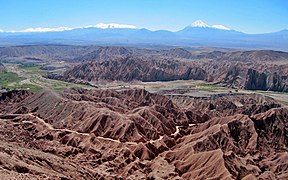
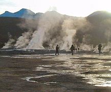
Atacama Desert, the driest in the world [14] —in October 2014, the travel guide publisher Lonely Planet highlighted this desert as the ninth among the ten regions that had to go in 2015—;[15] which has been inhabited for several thousand years, makes up the main portion of Norte Grande. A myriad of geoglyphs, petroglyphs and pictographs attest the presence of ancient cultures in the area. Among the most remarkable are those of Azapa Valley, Lluta Valley, the Atacama Giant and Pintados Geoglyphs, these latter are protected within Pampa del Tamarugal National Reserve. R. P. Gustavo Le Paige Archaeological Museum and Archaeological Museum of San Miguel de Azapa are home to the most important collections of artifacts and mummies in Chile, including the famous Chinchorro mummies, the oldest mummies in the world,[16] of Chinchorro culture developed between 5000 and 1700. C. The extreme aridity of the Atacama has been a key factor in the preservation of such archaeological remains. the Chuquicamata copper deposit, the largest open pit mine in the world;.[17] And the remains of extractions made from 12,000 and 10,000 years ago in a mine of iron oxide, the oldest mine on the continent.[18][19]
Arica is a coastal city with beautiful beaches and is also a starting point for travelers heading east to Putre for enjoying the majestic Puna landscape of Lauca National Park. Southward from Lauca, Volcán Isluga National Park includes ceremonial sites for the Aymara people.
Inland from Iquique, the desolate pampas are home to a few scattered towns and villages. Among those, the most interesting is the ghost town of Humberstone, declared World Heritage by UNESCO in 2005. In this area the tamarugo forests of the Pampa del Tamarugal break the barren monotony of the landscape.
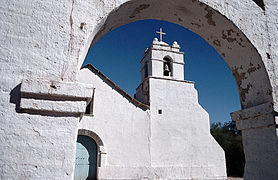
The altiplano of Norte Grande has a wide variety of natural scenery including salt flats, volcanoes, lakes and geysers. San Pedro de Atacama and surrounding area offer one of most spectacular combinations of archeology and awe-inspiring natural sights. San Pedro was the cradle of the Atacameño Culture. Villages with interesting cultural past are Caspana, Toconao, Socaire and Chiu Chiu. Notable are also the pre-Hispanic fortresses of Quitor, Lasana and Turi. Antofagasta is the largest city in Norte Grande. La Portada, a stunning natural arch, is located a short drive from Antofagasta.
Pan de Azúcar National Park is a park where sea and desert meet.
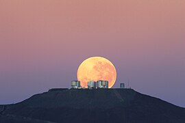
Also, there more than a dozen of astronomical facilities, including optical observatories and radio observatories. Among others, the most important are: Paranal (VLT), at an altitude of 2635 meters above sea level, is the world's most advanced and powerful astronomical observatory.[20] the ALMA (Atacama Large Millimeter Array), to date the largest astronomical project in the world;[21][22] and La Silla,[23] all dependent of ESO (European Southern Observatory).
In this area, it can see the flowering desert, a phenomenon that occurs between September and November (most in last years) with normal range rainfall in the desert.[24] In the end of the Norte Grande, near Putre, it can see the set formed by the Lake Chungará, one of the highest lakes in the world with 4500 m,[25] and Parinacota volcano. San Pedro de Atacama is very visited by foreign tourists to appreciate the architecture of the town, the highland lakes the Moon Valley, so-named because its landscape resembles the moon.
The coastal resorts of the area Norte Grande like Arica, Iquique, Antofagasta- host to the national tourism during the summer months.
-

-
 Valle de Atacama
 -
-
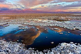 Salar de Atacama in the Atacama Desert
 -


Norte Chico
The Andes of Norte Chico are home to many of the highest volcanoes in the world, the highlight being the Ojos del Salado of 6891.3 m, the world´s highest volcano and the highest peak in Chile[26] -the second of the continent and Southern and Western hemisphere-.[27] Apart from Ojos del Salado and the rest of the volcanoes, attractions in this portion of the Andes include Nevado Tres Cruces National Park and Laguna Verde.
Norte Chico boasts some of the best beaches and exclusive coastal resorts in the country, such as Bahía Inglesa and those of La Serena, and Coquimbo - also these host to the national tourism during the summer months.
The clear skies of Norte Chico and its world-renowned infrastructure have made it ideal for astronomical tourism[citation needed].
Elqui Valley is a very popular destination. In January 2015, the travel section of The New York Times said the Elqui Valley as the 5th of the 52 places it had to visit in 2015.[28] Here, the dazzling green of the valley floor contrasts nicely with the barren brown slopes of the mountains that flank it.
Here it found El Tatio Geyser Field, the largest geyser fields in the Southern Hemisphere and the third in the world.[29]
The syncretism between Aymara tradition and Catholicism it has produced festivals and religious traditions -such as those dedicated to Virgen del Carmen in La Tirana and to Virgin of Andacollo- and carnivals. The Baile chino, one of the manifestations of religious fervor, was declared Intangible Cultural Heritage by UNESCO in 2014.[30]
-
-

-
 Ojos del Salado volcano
 -
 Elqui Valley, wine and pisco region
 -
 El Tatio geyser fields


Zona Central


.jpg?lang=en)
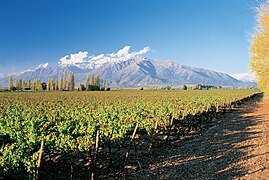
This area is home to the main ski resorts in Chile, which attract a significant number of tourists from the northern hemisphere because the reversed alpine skiing season. They are Chapa Verde, Portillo, Valle Nevado and Termas de Chillán. Furthermore, Wine tourism is common in Zona Central, and the Wine Routes of the Casablanca, Cachapoal and Colchagua valleys are some of the finest in Chile.
Apart from the national capital itself and its many attractions, the metropolitan region surrounding Santiago includes several attractions such as the Cajón del Maipo, Pomaire, and some of the oldest vineyards in the country, as well as various archaeological sites.[31]
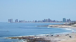
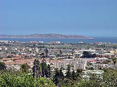
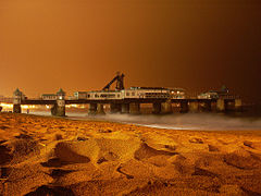
Due to its proximity to the capital, the coast of the Valparaiso Region is that during the summer months it has the largest number of tourists, primarily in the central coast and Viña del Mar. The latter city is considered the tourist capital of Chile[32] for its importance in the area thanks to its thirteen beachs,[33] its various entertainment centers -has one of major casinos of the country-,[34] and the International Song Festival of Viña del Mar, -the largest and best-known festival of Latin America, and considered the main of American continent.-.[35][36][37]
Valparaíso is a wonderful, amphitheater-shaped city, whose historic quarter has been recognized as a World Heritage Site.
Santiago, the capital and main urban center of Chile, home to many historic sites and heritage. Within the Greater Santiago, there are 174 heritage sites under the custody of Nationals Monuments Council (CMN),[38] among which are archaeological, architectural and historical monuments, in addition to typical or picturesque areas. Of these, 93 are located within the commune of Santiago, considered the historic center of the city[39] Although no Santiagan monument was even declared World Heritage by UNESCO, three have already been proposed by the Chilean government: the Incan sanctuary cerro El Plomo, the church and convent of San Francisco and Palace of La Moneda[40] Meanwhile, in June 2012, the magazine National Geographic said the Central Market of Santiago as the fifth best in the world[41] In January 2011 The travel section of The New York Times said the city of Santiago as the first of the 41 places it had to visit that year,[42] while the site specializing in tourism TripAdvisor considered it the sixth best destination of South America in 2012.[43]
The O'Higgins Region, south of Santiago, is known as "Huaso country" for its rural criollo culture.[44] Pichilemu, in the O'Higgins Region, is reputed to have the best beaches for Surfing in Chile, if not the world.[45] Other tourist sites in the O'Higgins region include the historically significant city of Rancagua, and the Rio de los Cipreses nature reserve.
Furthermore, in this area of the country are El Teniente, the most underground mine of copper in the world,[46] and the mining town of Sewell, declared a World Heritage Site by UNESCO in 2006.
Further south in the Maule and Bio Bio regions are the Radal Siete Tazas National Reserve and Laguna del Laja National Park.
-
-

-

-
 Vineyard near the Andes
 -


Zona Sur
Araucanía Region is the heartland of the Mapuche people. This area exhibits an incipient development of Indigenous tourism, in different sectors. in the coastal area of Araucania Ethnological tourism is developed on the banks Mapuche Budi Lake.
The Chilean Patagonia, the San Rafael Lake and its glaciers, the circuit of the Seven Lakes and various national parks like Conguillío, Vicente Pérez Rosales, the oldest in Chile and most visited of the country in 2011;[47] Torres del Paine selected as the eighth wonder of the world in 2013;,[48][49] Puyehue National Park between others.
The Andean sector of Araucania, highlight the great national parks, such as Conguillio National Park the forest of araucarias, Villarrica National Park, huerquehue National Park, Tolhuaca National Park besides the national reserves as Alto Biobio National Reserve, Malalcahuello National Reserve, Nalcas National Reserve, Malleco National Reserve, China Muerta National Reserve.
The capital of Araucania is Temuco, city of different service, hotels, tourist circuits, airport, markets, and the symbolic and historic sectors, the Cerro Ñielol Natural Monument is an icon of this city, and the most important tourist point.
Valdivia is one of Chile's most beautiful cities, recognition received mainly because of its lush natural surrounding. South from the city lies the colonial Valdivian Fort System.
Also in this area of the country are the Lake O'Higgins, the deepest lake of America and fifth in the world with 836 meters;[50] in the ice fields, the Glacier Pío XI (or Brüggen), the longest glacier in the southern hemisphere outside the Antarctic,[51] and Puerto Williams, the southernmost city in the world [52][53] On the other hand, several studies have located the oldest archaeological remains of the current Chilean continental territory in Monte Verde,[54] Los Lagos Region, about 14,800 B.C.,[55] at the end of Upper Paleolithic, making it the first known human settlement in America.[56]
The Lake District is characterized by piedmont lakes crowned by snowcapped volcanoes, whose lower flanks are covered with lush forests of native trees. Lovely lake resorts towns and villages dot the lakesides, chiefly Pucón, Villarrica, Frutillar and Puerto Varas. Puerto Montt is the tourist hub of the region; two of them, were considered among the best destinations in South America in 2012 by the specialized tourism site TripAdvisor.
The almost perfect cone of Osorno Volcano is an iconic landmark in the region. Alike Villarrica Volcano, which is one of the few volcanoes in the world that have an active Lava lake.
As an added bonus, this zone includes the granite domes of the Cochamó Valley.


Zona Austral
-
-
-
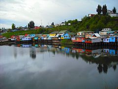 Palafitos in the archipelago of Chiloé
 -

-
 A kayaker runs a rapid on the Futaleufú River


Zona Austral is a premier destination for Ecotourism and Adventure travel. It features countless islands and islets, a maze of steep-sided fjords and channels, large glaciers and icefields and exuberant unspoilt temperate rainforests. Turbulent rivers descend from the Andes, chief of those being the Futaleufú River, which is widely considered one of the world's most challenging rivers for whitewater kayaking and rafting. Other opportunities for outdoor recreation, include hiking, cycling, sea kayaking and flyfishing.
Chiloé is characterized by having a rolling green countryside, but is better known for its peculiar wooden architecture and for its culture, which is full of myths and traditions. Also is remarkable its temperate rainforests.
The scenic Carretera Austral crosses or is nearby to many of the most popular destinations in this portion of Chile. Those include Pumalín Park, Yelcho Lake, Queulat National Park, Cerro Castillo National Reserve, General Carrera Lake and Caleta Tortel.
Laguna San Rafael National Park is the only park where visitors can contemplate at the same time the huge glaciers of Patagonia and the rich diversity of plants of the Valdivian Ecoregion.
Pío XI Glacier, one of the few advancing glaciers in the world, is a must-see in the Chilean Inside Passage.
Torres del Paine National Park is the main attraction in Zona Austral and one of the most beautiful national parks in the world.
The sprawling glaciers of the Cordillera Darwin, which is contained within Alberto de Agostini National Park, are reachable only by boat. Other typical destinations are Puerto Williams and Cape Horn.
-
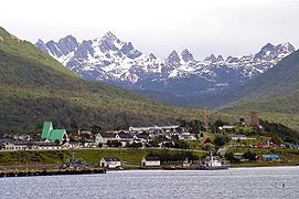
-
 Catedral de Mármol
 -
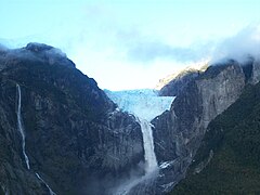
-
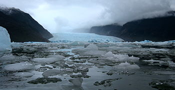
-
 Pío XI or Brüggen Glacier


Chile insular

In the middle of the Pacific Ocean, Easter Island, is world-renowned for its cultural, unique and natural heritage. Traditionally called Rapa Nui and previously known as Te pito o te henua ("The navel of the world") and Mata ki te rangi ('eyes looking at the sky'), is one of the main tourist destinations in Chile because of its natural landscapes and mysterious ancient culture of Rapa Nui people that since immemorial times, were developed completely isolated for centuries until it almost became extinct in the mid-19th century [57][58] Its most notable vestige corresponds to the over 1000[59] enormous and mysterious statues which have been shrouded in mystery since its discovery, are known as moai. To preserve these characteristics, the government given through the National Forestry Corporation (CONAF) the Rapa Nui National Park, while UNESCO declared this park as a World Heritage Site in 1995.[60]It is named Easter Island because it was discovered on Easter Sunday in 1722. Easter Island It
Among the activities that can be carried out in Rapa Nui are the different excursions and tours, visit the craft market, the Padre Sebastián Englert Anthropological Museum, the ceremonial center Tahai, the quarries of Puna Pau and Rano Raraku, the differents ahus the beaches of Anakena and Ovahe, the archaeological site of Orongo,[61] witness shows with music and island dances, and the annual festival Tapati Rapa Nui, the main artistic and cultural activity of the island, where are performed a series of ceremonies and traditions.[62]
The Juan Fernández archipelago is also well known for its jungles and endemic flora, formed by the islands Robinson Crusoe, Santa Clara and Alexander Selkirk, its geological origin is volcanic and its subtropical weather is rainy. Varied are the activities that can be performed, among which hiking, horseback riding, snorkeling, spearfishing, fishing, and observation of flora and fauna, which is mostly endemic. The Juan Fenández Islands are also known for being inhabited by Alexander Selkirk, the man who inspired the Robinson Crusoe novel. In 1966 the Chilean government renamed Island Más Afuera to Alejandro Selkirk and Island Más a Tierra to Robinson Crusoe, in order to promote tourism. Incidentally, Selkirk never set foot on Más Afuera, only on Más a Tierra. It can access the islands by the air and sea routes.
-
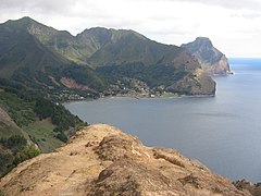 Cumberland Bay, Robinson Crusoe Island
 -
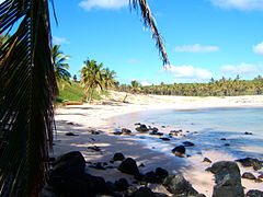 Anakena Beach
 -
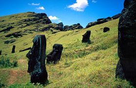 Moais on the slope of Rano Raraku
.jpg?lang=en)


Ethical Traveler Destination
Chile has been included in the 2010, 2011 and 2012 lists of "The Developing World's 10 Best Ethical Destinations." This is an annual ranking produced by Ethical Traveler magazine, which is based on a study of developing nations from around the world to identify the best tourism destinations among them. The benchmarking uses categories such as environmental protection, social welfare, and human rights.[63][64][65]
See also
References
- ^ World Tourism Organization (WTO) (2010). "Regional Results: Americas". UNWTO Tourism Highlights 2011 Edition (PDF). p. 8. Retrieved April 20, 2011.
- ^ Cite error: The named reference
wtowas invoked but never defined (see the help page). - ^ a b National Tourism Service (SERNATUR). "Studies and statistics - Statistics - Arrivals of foreign tourists to Chile - By nationality: Foreign tourists entered by nationality, 2011" (PHP) (in Spanish). www.sernatur.cl. Retrieved June 19, 2012. [dead link]
- ^ National Tourism Service (SERNATUR) (April 1, 2011). "Arrival of foreign tourists to Chile increased by 9% (in Spanish)". www.sernatur.cl. Retrieved April 8, 2011.
- ^ a b c National Statistics Institute (Chile) (INE) (October 2006). "Statistical Compendium 2006 (in Spanish)" (PDF). www.ine.cl. Retrieved November 29, 2007.
- ^ "Geography". Chile: A Country Study. Washington DC: GPO for The Library of Congress. 1994. Retrieved April 23, 2011.
- ^ Ministry of Foreign Affairs (June 21, 1955). "Decree 1747, 1955 of the Ministry of Foreign Affairs". Retrieved March 20, 2011.
- ^ Cite error: The named reference
dpdwas invoked but never defined (see the help page). - ^ Presidency of the Republic, Ministry General Secretariat of Government (MSGG) (2007). "National Geography: Location, size and extension (in Spanish)" (ASP). www.gobiernodechile.cl. Retrieved November 29, 2007.
- ^ Icarito. "Chile: A tri-continental country (in Spanish)". www.icarito.cl. Retrieved March 29, 2008.
- ^ Central Intelligence Agency (CIA) (2011). [=https://www.cia.gov/library/publications/the-world-factbook/fields/2060.html#ci "Coastline"]. www .cia.gov. Retrieved April 30, 2011.
{{cite web}}: Check|url=value (help) - ^ Lonely Planet (April 2, 2012). "Destinations - South America - Chile: Overview". www.lonelyplanet.com. Retrieved June 16, 2012.
- ^ Iglesias, Rafael (1987). "Chile - If you plan to visit Chile - Best Buys". Almanaque Mundial 1988 (in Spanish). Panama: Editorial América S.A. p. 252.
- ^ Bolívar Manaut, Luna (November 27, 2006). "A plenty of sun, good is the water". www.dw-world.de. Retrieved July 22, 2011.
- ^ Lonely Planet (s/f). "Best in Travel 2015: Top 10 regions - 9. Atacama Desert". www.lonelyplanet.com. Retrieved January 13, 2015.
{{cite web}}: Check date values in:|date=(help) - ^ Template:Publication cite
- ^ Codelco (s/f). "Operations - Chuquicamata". www.codelco.com. Retrieved November 22, 2011.
{{cite web}}: Check date values in:|date=(help) - ^ Rodríguez, F. (May 20, 2011). "Study confirms oldest mine in America was in Taltal (in Spanish)". La Tercera. p. 52. Retrieved May 21, 2011.
{{cite web}}: Italic or bold markup not allowed in:|publisher=(help) - ^ University of Chicago Press Journals (May 20, 2011). [=http://www.sciencenewsline.com/archaeology/2011052013000004.html "Archaeologists uncover oldest mine in the Americas"]. ScienceNewsline. Retrieved May 21, 2011.
{{cite web}}: Check|url=value (help) - ^ "Yepun and the Milky Way". Retrieved 22 June 2015.
- ^ European Southern Observatory (ESO) (s/f). "ALMA (in Spanish)" (PHP). www.eso.cl. Retrieved December 4, 2011.
{{cite web}}: Check date values in:|date=(help) - ^ ALMA (s/f). "Atacama Large Millimeter/submillimeter Array". www.almaobservatory.org. Retrieved December 4, 2011.
{{cite web}}: Check date values in:|date=(help) - ^ European Southern Observatory (ESO) (s/f). "La Silla Observatory (in Spanish)" (PHP). www.eso.cl. Retrieved December 4, 2011.
{{cite web}}: Check date values in:|date=(help) - ^ Agence France-Presse (November 7, 2011). "The Atacama desert flourishes as never in the past 20 years (in Spanish)". www.lasegunda,com. Retrieved June 22, 2013.
- ^ Drews, Carl (August 20, 2010). "The Highest Lake in the World". www.highestlake.com. Retrieved June 11, 2012.
- ^ "Ojos del Salado -Cara Norte/North Face" (PDF) (in Spanish and English). www.los6000dechile.cl. s/f. Retrieved March 9, 2011.
{{cite web}}: Check date values in:|date=(help)CS1 maint: unrecognized language (link) - ^ Turrel, Marc, and Jorge Velasco (May 18, 2007). "Ojos del Salado, the highest volcano in the world (in Spanish)" (PHP). desnivel.com. Retrieved July 20, 2008.
{{cite web}}: CS1 maint: multiple names: authors list (link) - ^ The New York Times (January 9, 2015). "52 Places to Go in 2015 - 5. Elqui Valley, Chile". www.nytimes.com. Retrieved January 13, 2015.
- ^ Glennon, J. A., y R. M. Pfaff. "The extraordinary thermal activity of El Tatio Geyser Field, Antofagasta Region, Chile". www.alanglennon.com. Retrieved November 27, 2013.
{{cite web}}: CS1 maint: multiple names: authors list (link) - ^ United Nations Educational , Scientific and Cultural Organization (UNESCO) (2014). "Intangible Cultural Heritage - Chile: Baile Chino" (PHP). www.unesco.org. Retrieved June 1, 2015.
- ^ "Arqueologia.cl". Arqueologia.cl. Retrieved 2 November 2012.
- ^ "Inicio - Our city Viña del Mar". www.visitevinadelmar.cl. s / f. Retrieved May 7, 2012.
{{cite web}}: Check date values in:|date=(help) - ^ Cite error: The named reference
vvmwas invoked but never defined (see the help page). - ^ Pizarro R., Karen (s/f). "Crossing Chile - Meet the Viña del Mar Casino (in Spanish)" (PHP). www.chile.com. Retrieved May 7, 2012.
{{cite web}}: Check date values in:|date=(help) - ^ Template:Publication cite
- ^ Floras, Stella (February 18, 2013). "Iceland: Hera Björk in the final of Viña del Mar International Song Contest 2013". www.esctoday.com. Retrieved March 7, 2013.
[T]he Viña del Mar International Song Contest [is] the oldest and biggest music festival in Latin America
- ^ CNN México (February 23, 2010). "Paul Anka ended with great success, the first day of Viña del Mar (in Spanish)". mexico.cnn.com. Retrieved May 27, 2013.
The International Song Festival of Viña del Mar is the most important musical event of the continent
{{cite web}}:|author=has generic name (help) - ^ Nationals Monuments Council ( CMN). Search of monuments in the provinces of Santiago and Cordillera and the commune of San Bernardo. URL accessed on December 23, 2007
- ^ Nationals Monuments Council (CMN) (s/f). "Monuments of the commune of Santiago". www.monumentos.cl. Retrieved December 23, 2007.
{{cite web}}: Check date values in:|date=(help) - ^ United Nations Educational, Scientific and Cultural Organization (UNESCO) (February 23, 2004). "Tentative Lists: Chile". whc.unesco.org. Retrieved December 23, 2007.
- ^ National Geographic (s/f). "Top 10 Food Markets". travel.nationalgeographic.com. Retrieved June 11, 2012.
{{cite web}}: Check date values in:|date=(help) - ^ The New York Times (January 7, 2011). "The 41 Places to Go in 2011 - 1. Santiago, Chile". travel.nytimes.com. Retrieved June 10, 2012.
- ^ "Top 25 Destinations in South America". www.tripadvisor.com. 2012. Retrieved June 13, 2012.
- ^ "About Chile & It's People". O'Higgins Tours. Retrieved 2 November 2012.
- ^ "Pichilemu". TurismoLibertador. Retrieved 2 November 2012.
- ^ Codelco (s/f). "Operations - El Teniente (in Spanish)". www.codelco.com. Retrieved November 22, 2011.
{{cite web}}: Check date values in:|date=(help) - ^ Poblete, J. (4 February 2012). "Park Vicente Perez Rosales becomes the most visited in Chile (in Spanish)" (PDF). The Third. Retrieved February 10, 2012.
- ^ "8th Wonder of the World". www.virtualtourist.com. 2013. Retrieved November 1, 2013.
- ^ "Chile's Torres del Paine National Park Selected as 8th Wonder of the World by VirtualTourist Voters". www.advfn.com. November 1, 2013. Retrieved November 1, 2013.
- ^ Center for Scientific Studies (CECS) (2010). "Determine that O'Higgins lake is the deepest fifth of the world" (PHP). www .cecs.cl. Retrieved May 23, 2012.
- ^ Laboratory of Glaciology (s/f). "Glacier inventory - Table 1". www.glaciologia.cl. Retrieved May 21, 2012.
{{cite web}}: Check date values in:|date=(help) - ^ "Hispanic World - Wonders Tourist: Tierra del Fuego (Arg./Chi.)". Almanaque Mundial 1988. Panama: Editorial América S.A. 1987. p. 92.
{{cite book}}:|access-date=requires|url=(help) - ^ Puerto Williams, located in 54°55′59″S 67°37′0″W / 54.93306°S 67.61667°W It is the administrative settlement southernmost of the world -it host a governor and provincial capital-; however, excluding the military bases and Antarctica, Puerto Toro, located in 55°04′56″S 67°04′27″W / 55.08222°S 67.07417°W, is the southernmost permanent human settlement in the world
- ^ Template:Publication cite
- ^ Organization United Nations Educational, Scientific and Cultural Organization (UNESCO) (2004). "Monte Verde Archaeological Site". whc.unesco.org. Retrieved April 2, 2011.
The site shows the existence of a group of people that lived there [...] about 14.800 years ago according to the calibrated dates of carbon 14
- ^ Salisbury, David F. (2008). "New Evidence About Earliest Americans Supports Coastal Migration Theory". Vanderbilt University. Retrieved April 2, 2011.
New evidence from the Monte Verde archaeological site [...] confirms its status as the earliest known human settlement in the Americas
- ^ Diamond, Jared (August 1, 1995). "Easter's End" (HTM). www.dieoff.org. Retrieved March 22, 2012.
- ^ Calderón A., Enrique (February 17, 2007). "Collapse: Easter Island (in Spanish)" (PHP). La Jornada. Retrieved 22 March 2012.
{{cite web}}: Italic or bold markup not allowed in:|publisher=(help) - ^ Van Tilburg, Jo Anne (May 22, 2012). "Easter Island Statue Project - Easter Island heads have great bodies!". Retrieved June 19, 2012.
- ^ Cite error: The named reference
pdHwas invoked but never defined (see the help page). - ^ "Zone 8 Sporadic Islands - Easter Island Sector". Turistel-Tourist Guide Chile - Center (in Spanish) (14th ed.). Santiago, Chile: Cochrane S.A. 1999. pp. 230–232. ISBN 956-7264-45-7.
{{cite book}}:|access-date=requires|url=(help); Cite has empty unknown parameter:|cite=(help) - ^ Cottages Hinariru Nui (2011). "Data - Tapati Rapa Nui" (HTML). www.hinarirunui.cl. Retrieved June 19, 2012.
- ^ "Ethical travel destinations unveiled: Argentina, Barbados, Chile". The Independent. Relaxnews. 2010-12-10. Retrieved 2010-12-11.
- ^ Jane Esberg, Jeff Greenwald and Natalie Lefevre. "The Developing World's 10 Best Ethical Destinations". Ethical Traveler. Retrieved 2010-12-11.
- ^ "The Developing World's 10 Best Ethical Destinations: 2012". Ethical Traveler. 2012-01-05. Retrieved 2012-01-26.
External links
- National Tourism Service
- Virtual Tour in 360° of Chile
- Travel: Chile by Rich Grant, International Business Times, May 11, 2009
- Traveling in Chile - this is Chile - Official Chile website
- El colorado official site
- Ski guide of Chile.
- Federation of Ski and Snowboard of Chile
- Chile Travel Blog Directory
| History |
|  | |||||||||
|---|---|---|---|---|---|---|---|---|---|---|---|
| Geography | |||||||||||
| Politics |
| ||||||||||
| Economy | |||||||||||
| Society |
| ||||||||||