Laguna del Laja National Park: Difference between revisions
m updating region name + cats, replaced: Biobío Region → Bío Bío Region, Bío-Bío → Bío Bío (3) using AWB |
No edit summary |
||
| Line 29: | Line 29: | ||
==Biology== |
==Biology== |
||
[[Image:Antuco l7 2000027.jpg|thumb|250px|NASA image]] |
|||
The Park lies within the [[Valdivian temperate forests]] [[ecoregion]].<ref name=ecoregion>{{cite journal |author = Olson, D. M, E. Dinerstein, ''et al'' |title = Terrestrial Ecoregions of the World: A New Map of Life on Earth |journal = [[BioScience]] |year = 2001 |volume=51 |issue=11 |pages= 933–938 |url = http://gis.wwfus.org/wildfinder/ |doi = 10.1641/0006-3568(2001)051[0933:TEOTWA]2.0.CO;2 }}</ref> |
The Park lies within the [[Valdivian temperate forests]] [[ecoregion]].<ref name=ecoregion>{{cite journal |author = Olson, D. M, E. Dinerstein, ''et al'' |title = Terrestrial Ecoregions of the World: A New Map of Life on Earth |journal = [[BioScience]] |year = 2001 |volume=51 |issue=11 |pages= 933–938 |url = http://gis.wwfus.org/wildfinder/ |doi = 10.1641/0006-3568(2001)051[0933:TEOTWA]2.0.CO;2 }}</ref> |
||
| Line 38: | Line 37: | ||
==Tourism== |
==Tourism== |
||
Several activities can be performed within the boundaries of the park and in the surrounding area including [[climbing]], trekking, [[skiing]] and [[fishing]]. |
Several activities can be performed within the boundaries of the park and in the surrounding area including [[climbing]], trekking, [[skiing]] and [[fishing]]. |
||
{{panorama|panoplaja.jpg|1000px|<center> Panoramic of Laguna del Laja National Park, climbing the mountains. In the top right (white tip) shows the [[Antuco (volcano)|Volcano Antuco]].</center>}} |
|||
<gallery> |
|||
File:Cascadaplaja.jpg|One of the park's waterfalls |
|||
File:plaja.jpg|in the park |
|||
File:Vantuco1.JPG|[[Antuco (volcano)|Volcano Antuco]] |
|||
File:Caverna hielo.JPG|thumb|Ice caves formed at the foot of the Sierra Velluda in summer. |
|||
</gallery> |
|||
==References== |
==References== |
||
Revision as of 00:41, 15 October 2012
| Laguna del Laja National Park | |
|---|---|
 Antuco volcano | |
| Location | Bío Bío Region, Chile |
| Nearest city | Los Ángeles |
| Area | 119 km² |
| Established | 1958 |
| Visitors | 19,467 (in 2004) |
| Governing body | Corporación Nacional Forestal |
Laguna del Laja National Park is a national park of Chile located in the Andes, between 37°22’ and 37°28’ south latitude and 71°16’ and 71°26’ west longitude.[1]
Geography
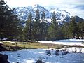
The park features spectacular mountain landscapes, whose main attractions are the Antuco Volcano, Sierra Velluda and Laguna del Laja (Laja Lake). The latter gives the name to this protected area, but it only borders the park. The park ranges in elevation from 976 m to 3585 m at Sierra Velluda.[1] Although a little snow caps Antuco volcano, much more snow adorns the two major summits of its southern neighbor, even during Chile’s summer. Sharp ridges and deep valleys carve this rugged region, which alternates between bare rock and lush vegetation.[2] Another summit in the park, although least prominent, is Cerro Cóndor at 1,668 m.[1]
The park forms part of the Bío Bío River basin. Some small tributaries of Laja River originate in the park.
Biology
The Park lies within the Valdivian temperate forests ecoregion.[3]
It is home to a wide variety of wildlife, including the Cougar and foxes (particularly the Chilla and the Culpeo). In the park have been identified 47 bird species.[4]
Endangered and rare vegetation species are found in the park. Among them are: Ciprés de la Cordillera, Araucaria, Maitén del Chubut and Radal Enano.[4]
Tourism
Several activities can be performed within the boundaries of the park and in the surrounding area including climbing, trekking, skiing and fishing.

-
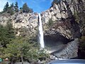 One of the park's waterfalls
 -
 in the park
 -

-
 Ice caves formed at the foot of the Sierra Velluda in summer.


References
- ^ a b c "Plan de Manejo Parque Nacional Laguna del Laja" (PDF). Documento de Trabajo. CONAF. Retrieved 2007-02-05.
- ^ "Cerro Antuco and Laguna de Laja, Chile". EO Newsroom: New Images. NASA. Retrieved 2007-02-05.
- ^ Olson, D. M, E. Dinerstein; et al. (2001). "Terrestrial Ecoregions of the World: A New Map of Life on Earth". BioScience. 51 (11): 933–938. doi:10.1641/0006-3568(2001)051[0933:TEOTWA]2.0.CO;2.
{{cite journal}}: Explicit use of et al. in:|author=(help)CS1 maint: multiple names: authors list (link) - ^ a b "Áreas Silvestres". Región del Bío Bío. Sernatur. Archived from the original on 2006-09-24. Retrieved 2006-11-24.