Gran Sabana: Difference between revisions
No edit summary |
No edit summary |
||
| Line 176: | Line 176: | ||
[[File:Gran_Sabana_Quebrada_de_Jaspe_I_(1).JPG|thumb|250px|left|The Jasper Creek is a river whose waters circulate in a smooth surface of [[jasper]], red and black, mostly]] |
[[File:Gran_Sabana_Quebrada_de_Jaspe_I_(1).JPG|thumb|250px|left|The Jasper Creek is a river whose waters circulate in a smooth surface of [[jasper]], red and black, mostly]] |
||
To reach the |
To reach the town of Kavak, where the gorge of the river of that name, it is essential to travel by air. In the second half of 2011, however, vehicles banned from some of the unpaved roads, such as at the River Torón. This measure was taken by the Government, because the soil condition was badly damaged by the passage of four wheel drive vehicles. The most important falls, and easier access on the main road, that can be reached without four wheel drive vehicles are the Falls Kama or "Kama-Merú" in Pemon language, Pacheco Creek or "Arapan-Merú" and Jasper Creek or "Kako Paru". |
||
Another issue to consider to move in the Gran Sabana is the supply of gasoline. There are few suppliers of fuel, and not everyone is always open. Most likely to find gasoline in Santa Elena has Uairén, however, the |
Another issue to consider to move in the Gran Sabana is the supply of gasoline. There are few suppliers of fuel, and not everyone is always open. Most likely to find gasoline is in Santa Elena has Uairén, however, the town is over 200 km from the entrance to the Gran Sabana by La Escalera. For foreign tourists the fuel supply is not guaranteed, because the government guarantees gasoline only for Venezuelans. There is also differentiation of supply for Venezuelan tourists and local, due to smuggling of gasoline in Brazil has a much higher value than in Venezuela. The same problem of illegal purchase and sale of gasoline is before the entrance to the Gran Sabana, the Venezuelan side, in the town of San Isidro, also known as "Km 88". |
||
| ⚫ | |||
| ⚫ | |||
| ⚫ | Some tranches can be done in "curiaras", which are boats carved in wood, manned by local people. Despite being managed by pemones, these boats may have engines to reduce travel time. Such is the case of access to Falls Aponwao one of the most renowned for its majestic in the Gran Sabana, with a fall of about 110 meters. To get the fall is due to arrive by car to the camp Liwöriwö by ground road, and then take the curiara guided by Indigenous (a journey of about 20 minutes) until the fall. |
||
| ⚫ | |||
| ⚫ | |||
| ⚫ | Another high tourist activity, albeit at a price somewhat less accessible, is to fly by helicopter or plane. It can take flights from many places, however, the most common is to take off from Santa Elena de Uairén, where local agencies. Some plans include tours on tepuis Roraima and Kukenan, visits to waterfalls, overlooking Auyantepuy with overflight of Angel Falls and camp visits of Canaima, which is not accessible by vehicle. |
||
| ⚫ | Some |
||
| ⚫ | Another high tourist activity, albeit at a price somewhat less accessible, is to fly by helicopter or plane. |
||
=== Sites of interest === |
|||
* Falls Aponwao (Chinak-meru) |
|||
* Falls Kamá (Kamá Meru) |
|||
* Falls Kamá (Kamá Mesalto) |
|||
* [[Falls Kawi]] (Kawí merú) |
|||
* [[Falls Kukenan]] |
|||
* Falls Yuruaní |
|||
* Falls Karuay |
|||
* La Laja |
|||
* El Paují |
|||
* El Abismo |
|||
* Santa Elena de Uairén |
|||
* Mission of Kavanayen |
|||
===Photo Gallery=== |
|||
<center> |
|||
{{Gallery |
|||
|title= |
|||
|width=160 |
|||
|File:Laguna Verde - San Isidro Km 88.jpg|A small lake of green water in the Km ''88'' |
|||
|File:Salto Kama - Gran Sabana.jpg|Falls Kamá |
|||
|File:Ptarí and Sororopán tepuis panoramic view.jpg|Panoramic view of the tepuis Ptarí and Sororopán |
|||
|File:Quebrada de Jaspe II.jpg|Well in Jasper Creek II |
|||
|File:Gran Sabana paisaje 1.jpg|Typical landscape |
|||
|File:Atardecer Kukenan pared roja.jpg|Last rays of the setting sun on the wall of the tepui Kukenan |
|||
|File:Piedra de la Virgen 1.JPG|Stone of the Virgin |
|||
|File:Tepui in Gran Sabana.jpg|Tepuy at sunset |
|||
|File:Mt Roraima in Venezuela 001.JPG|Mount Roraima from Tëk River Camp |
|||
|File:Mt Kukenan in Venezuela 001.JPG|Kukenan |
|||
|File:Kavanayén panorámica tepuys.jpg|Overview of tepuis from Kavanayen |
|||
|File:Aponwao.jpg|Upper Falls Aponwao |
|||
}} |
|||
</center> |
|||
==External links== |
==External links== |
||
Revision as of 15:16, 5 August 2012

La Gran Sabana (Spanish pronunciation: [la ɣɾan saˈβana], English: The Great Savanna), also known as Guianan savanna, is a region located in southeastern Venezuela, in the Guiana Highlands, also south-east in Bolívar State, and extending until the border with Brazil and Guyana. The Gran Sabana has 10,820 km ² and is part of one of the largest National Parks in Venezuela, the Canaima National Park. The average temperature is around 20 º C, but at night can drop to 13 ° C, and in some of the most elevated sites, depending on weather, may fall a bit more. The location offers unique landscapes around the world, has rivers, waterfalls and gorges, deep and vast valleys, impenetrable jungles, and savannahs that host a large number and variety of plant species, a diverse fauna, and the plateaus better known as tepuis.
History

During the time of the Conquest and Colonization, the extent of the territories of Guiana and its natural resources gave rise to the legend of El Dorado, which caught the attention of adventurers, explorers and settlers. They eventually came to these shores in search of gold, gems and other valuable products. Thus began the exploration of a territory so vast and difficult to access, which to date has several areas that nobody has come.
Due to the richness and diversity, both biological and mineral and geographical of Southeast Guayana, was necessary to protect the territory by the Government of Venezuela. For this reason, Canaima was declared National Park, many years later by Executive Order No. 770 dated June 12, 1962. The park is the second largest of country.
The Canaima National Park now covers an area of about three million hectares (about 30,000 km ²), which places him among the six largest national parks in the world. However, its original area was of one million hectares, and did not include the territory of the Gran Sabana.

It was enlarged in 1975 to cover several points of high ecological importance. Among those sites are: Carrao River Basin, the headwaters of the Caroní River, the Sierra de Lema, the source of the Cuyuni River and the rolling plains, which form the Gran Sabana. Currently, the territory of the Gran Sabana is of 1,082 000 hectares, as shown in the image of the park entrance sign.
Currently, the Gran Sabana remains a place of high ecological value, not only for UNESCO, proclaimed World Heritage Site in 1994 to give that title to Canaima National Park, but also to the Government, which promotes conservation and exploration, and for the people of Venezuela: Thousands of tourists visit the place every year. They can enjoy the variety of natural wonders in the park and delight both for the beauty of its places of interest (his only relief, shaped landscapes of the tepuis, waterfalls and streams), and its diversity of fauna and flora. The latter attract many scholars and scientists from around the world. Only in the Gran Sabana is 40% of the species of Venezuela, and 23% in terms of reptiles and amphibians, with many endemic species.
The largest city in the area is Santa Elena de Uairén. Has experienced very rapid growth, with a population of over 30,000 habitantes. It was founded in 1923 by Lucas Fernández Peña, attracted by the growth of diamonds in the area. Its average temperature is between 25 and 28 ° C. It is located at 910 meters above sea level, is 15 km from the border with Brazil, 615 km from Ciudad Guayana, and about 1,400 km from Caracas, paved road. The total population of the Gran Sabana is currently estimated at about 48,000 habitantes.
Geography
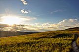
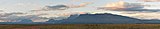
As mentioned above, the Gran Sabana is a park with unique characteristics. The beauty of the landscape is accentuated in the Guiana Shield, the oldest geological formation of the earth. It consists of two main geological formations, an igneous metamorphic age of approximately 2,000 million years and a layer of sedimentary rocks, sandstones of the Roraima formation, deposited makes about 1,700 million years. These sandstones sedimented in a lake or ocean, reaching thicknesses of several kilometers. Were originally united in one or more plates with some linearity, but were fractured and eroded over hundreds of millions of years. During these eras were alternated humid and warm climates. This region was subjected to several periods of uplift and subsidence tectonics, and because of this, certain areas of the shield were more prone to erosion than others. This determined the presence of large sandstone beds are isolated, called "tepuis" in the language of the indigenous inhabitants of the region. The relief of the region is slightly wavy. The average height is about a thousand feet high, but it can vary considerably over short distances: the road of El Dorado to Santa Elena de Uairén is of 200 meters to 1,500 in less than 30 km, in a place called "La Escalera", a raise with a paved street. Its condition of savanna is not due to climate (which is enough rain to support a forest vegetation), but the formation of rocky and sandy soils, although parts of the jungle can be seen in some depressions and, above all, forests gallery along the rivers.

Hydrography
La Gran Sabana, and the rest as Venezuela in general, is rich in river networks. The main drainage sub-basins are formed by the rivers Yuruaní, Aponwao, Kukenán, Suruku, Ikabarú, Karuay, Urimán and Antabare.

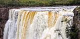
Note that the Caroní River, of 925 km in length, and flow rate equal to 5000 m³/s, from which Venezuela gets most of its electricity by hydropower exploitation with, originates from several tributaries coming from tepuis and mountains of the Gran Sabana, as the Aponwao, the Yuruaní and the Kukenan. The vast majority of rivers and streams in the region are of dark waters, with coloration similar to that of tea. The waters are very poor in dissolved nutrients and rich in humic acids and tannins, which give them its characteristic brown color. The acidity is quite high, reaching PH3-4, and although this may cause acidity in visitors that taste first these waters, it can say that these are among the least polluted waters in the world. As to tourist interest, the rivers are of great importance, as visitors who travel the roads of the Gran Sabana usually use for recreation, swimming, and camping. These are usually easily accessible and that the entries are found throughout the main road, and many are arranged with steps for easy access. At several points, the Pemones offer guidebooks and/or ask for contributions of money in exchange for keeping clean areas.
Tepuys
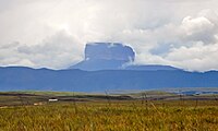
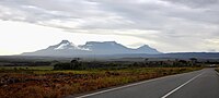
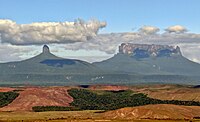
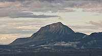
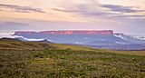
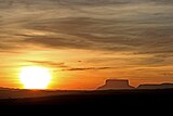
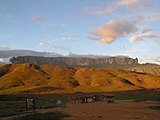
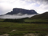
In the Gran Sabana is randomly distributed ancient massifs eroded in tabular form, known as tepuis, examples of inverted relief, which form a kind of typical plateaus of the Guiana highlands. These plateaus, in the Gran Sabana, reach its maximum altitude in the Tepui Roraima, with nearly 2,800 meters above sea level.
Auyantepui
Although the Auyantepui not part of the Gran Sabana as the exact delimitation of the territory, is considered by many to be part of it, being the most famous tepui throughout Guiana. It is located in Canaima Northwest and is one of the most recognized tepuis in the world, because it comes from the highest waterfall in the world, the Angel Falls (named for the local indigenous "Karepacupai-merú") with almost 979 meters fall libre.

This Falls was discovered by the explorer aviator Jimmy Angel in 1937. It attempted to land his plane on top of Auyantepui, crashing (without fatalities) in one of his expeditions. Is the second largest Guiana tepui, with its surface of 700 km ², after Chimantá. It has an altitude of 2,535 meters. The Auyantepui is inclined on its surface: on the southern edge exceeds 2,400 meters, while the northern edge of 1,600 barely meters.
It can access the southern part of Auyantepui and climb. In some sections of the trip is necessary to use ropes to climb, although the difficulty level is not high. To make the ascent to the tepui is necessary to reach the village of Kavak by plane or helicopter, as there is no vehicle access routes to the tepui.
Chimantá Massif
The Chimantá Massif is the formation of plateaus (10 in total, among which Amurí, Churí, and Akopán-tepui) largest in all of Venezuela, with its 1,470 km ². The tepui is not easily accessible, and is not visited by tourists. It is located in the central-western Canaima. Recently, the Venezuelan scientist Charles Brewer Carías, flying over the massif discovered a huge cave entrance to a 250 meters high. From this observation had two expeditions, one of which found the same Brewer Carías, among many other innovations a new species of frog, named in his honor Colostethus breweri.
Mount Roraima
.JPG?lang=en)
It is the highest tepui of the National Park. It is also known as Blue Mountain or Crystal Mountain, and is considered by the local Indians as a divinity. The Pemon believe that most tepuis host powerful spirits or entities to which they respect and fear. Some of them even make offerings and prayers at the top in her infrequent visits to the tepui (usually as tourist guides in exchange for money and/or food. Its height is about 2,800 meters, covers an area of 15 km long and its surface is 200 km ². Its walls, completely vertical, may reach 500 meters high.

Despite this, over this wall, is an outstanding area, with tilt and space for tourists to climb to the top. Among the attractions are the Valley of the crystals (a deposit of quartz formations), the Jacuzzi area (where water wells of greenish-yellow color), the viewpoints of La Ventana and El Abismo, the North Mazes, la Proa, Lake Gladys, and the "Triple Point". This point is located in the northeast of the tepui, and is the place where it meets the border between Brazil, Venezuela and Guyana. Are also very attractive rock formations eroded by wind, leading to myriad interpretations of figures , as the formations of the "flying turtle", the "Mexican hat", the "monkey eating an ice cream cone," or the "elephant", shown in the image.
Kukenan (Matawi-tepui)
Incorrectly named and widely known as Kukenan-tepui, this plateau is real called Matawi-tepui. It has a height of 2,680 meters and was first climbed in 1963. This expedition was organized by the University of Bangor, England. The Matawi-Tepui chain belongs to the eastern tepuis of the Gran Sabana, along with the Yuruani-tepui. Also born the Kukenan Falls listed as the tenth highest waterfall in the world with its 629 meters of free fall.

Other tepuis
Other recognized tepuis are in the chain Ilú-Tramén-Karaurín, as well the Wadaka-piapó (or Wadakapiapü) and the Yuruaní, which together with the Kukenan and Roraima, in the chain of the 7 eastern tepuis. These also highlight the tepuys Iglú-tepui, Ptarí-tepui, Acopán-tepui and the Sororopán-tepui, which has a tilt feature, and can be climbed. There are a large number of minor tepuis, however, can be found tepuis along the whole of Canaima, the total of these around 150. Most tepuis reach heights ranging between 2,000 to 2,700 m.
-
 Ptarí-tepui
 -
 Tepuis Ilú, Tramén and Karaurín
 -
 Tepuis Wadaka-piapó and Yuruaní
 -
 Moná-tepui
 -
 Tepui Chiricayen


Climate
Temperature
Due to the elevation at which there is the Gran Sabana, about 1,000 meters high on average, the weather is quite pleasant, mild with average annual temperature of 20 ° C, similar to the valley of Caracas.

However, due to rainfall, which abound throughout the year, and therefore its cloud cover, the average annual temperature is lower, and daily temperature variations. Minimum temperatures rarely dropping below 8-10 ° C (unless it is on top of the tepuis higher exposed, such as Roraima, overnight). The maximum usually not exceeding 32-35 ° C

Precipitation
Rainy season prevails about 10 months, with a period of relative drought between January and March with annual average between 1,600 and 2,200 mm of rain (twice what is observed in the Venezuelan capital). This measure is not invariant along the savanna area, in the south the average drops to between 1,600 and 1,900 mm of rain, in the north varies between 1,600 and 2,500 mm, and in the south-east is above of 3,000 mm.
Winds
Visitors to the Gran Sabana may notice strong winds to finish up the area of La Escalera and see for first time large areas of savannah. Compared to the average weather of Venezuela, the site moved relatively favorable and cool winds, creating a comfortable feeling. Climate variation is determined by altitude and winds, as the latitude (between 4 ° and 8 ° latitude north) of the site falls within the equatorial belt. The area further north in its lower part, is subject to the influence of winds from the east and northeast, resulting in a rainy season and drought season. The south by contrast, is affected by wet winds from the Amazon depression and Southeast, which condense when in contact with elevations, producing heavy rains.
Flora and vegetation
The savannas occupy undisputed first place in the diverse range of ecosystems that developed in the region. But the Gran Sabana is comprised of a variety of scenarios. These are subject to a complex mix of climatic and ecological conditions ranging from hot lowlands to the high cold mountains. Because of this, it have developed a considerable number of plant species adapted to its ecosystems. The vegetation is characterized by be particular in the region and builds on very acid soils, derived from the decomposition of the sandstones. Dominate the savannas and gallery forests, which are situated along the courses of rivers and streams that traverse the savannahs. These forests have a very varied vegetation where there are trees, shrubs, guacos, epiphytes and the Moriche Palm Mauritia flexuosa. Shrubs rarely exceed 2-3 meters high. Its leafs are mostly thick, probably due to lack of nutrients in the soil, and its acid. La Gran Sabana has a grassy vegetation of grasses, that due to the ground with many rocks and sandy, not make it suitable for feed any livestock, whether goat, sheep or bovine. The most important plant families are Theaceae, Humiriaceae, Ericaceae, Compositae, Aquifoliaceae, Burseraceae, Sapotaceae. Among the most high, it should be emphasized Rutaceae the Spathelia Fruticosa with unbranched stems up to four meters, and a tuft of compound leafs at the apex. On the summits of the tepuis, despite the hostile environment (especially on Mount Roraima), there is a wide variety of plants, ranging from 20 to 30 centimeters to four meters high. In the turbulent rivers and in the many waterfalls, plants grow on the rocks peculiar carpets that are green or tan. These are Spermatophyte plants of the family Podostemaceae. Between 600 to 1,200 meters above sea level begins to observe the submontane evergreen forests ombrophilous, upper-middle-high (20-30m) thick and well developed understory. From the 1,200 meters to 2,000 meters at the foot of the cliffs within large Tepui grow ombrophilous montane forests evergreens, including low tepui forests above 1,700 m. These form dense communities of medium to high altitudes, with undergrowth closed, sometimes with many epiphytes. At the summit of the Auyantepui and the Massif Chimantá there are several kinds of plants do not grow anywhere else in the world, such as gender Ayensua (family Bromeliaceae), Tepuia (Ericaceae), Mallophyton (Melastomataceae), Coryphothamnus and Aphanocarpus (Rubiaceae), and finally Arimantaea and Achnopogon (Asteraceae). Many of the rarest species are found on exposed sandstone formations open. Furthermore, in shady and protected beneath the rocks and small cavities, are achieved endemic ferns of the genus Hymenophyllopsis and Pterozonium. The flora has been one of the most important attractions for botanical studies, found insectivorous plant communities belonging to the genera Heliamphora, Drosera and Utricularia. These live in the thin layer of soil resting directly on the bedrock.


Fauna
Despite the enormous variety of species living in the Gran Sabana, is not common for visitors to find animals on the road to El Dorado to Santa Elena de Uairén, because there prevails the open forest, and these animals prefer the islands forest, riparian forests, and jungles that are in the mountains at the foot of the tepuis.
Savanaian wildlife species include endangered species like the giant anteater (Myrmecophaga tridactyla), the giant armadillo (Priodontes maximus), the giant Amazon otter (Pteronura brasiliensis), the ocelot (Leopardus pardalis), the paca Agouti paca, or the marsupial endemic of the tepui summits (Marmosa tyleriana). It also has its habitat in this region of the Orinoco capuchin monkey (Chiropotes satanas), the howler (Alouatta seniculus) and the widow monkey (Pithecia pithecia). The avifauna is varied, especially the cock of the rock (Rupicola rupicola) and the harpy eagle (Harpia harpyja). Among the reptiles are: the Boa constrictor, the anaconda (Eunectes murinus) and the pineapple cuaima (Lachesis muta muta). Many species of amphibians live in wet areas, including mining frog (Dendrobates leucomelas).
Other common species include the armadillo (Dasypus novemcinctus), the small cuspa (Cabassous unicinctus), or capybara (Hydrochoerus hydrochaeris), the higher rodent of the world. You can also find very rare event, jaguars (Panthera onca), pumas (Felis concolor), ocelots (Leopardus wiedii) and Tigritos (Panthera tigris). They have been porcupines (Sphiggurus insidiosus), cuchicuchis (Potos flavus) and weasels (Mustela nivalis), which are creatures of habit generally arboreal. Another interesting mammal from zoological point of view is the bush dog (Speothos venaticus), seldom sighted and only in forests of this region.
The fauna of the tepuis is found in very low, due to the low amount of nutrients and harsh environmental conditions on the tops of the plateaus.
-
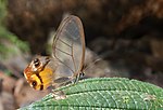 Butterfly Haetera piera
 -
 Frog on Kavanayén
 -
 Oreophrynella quelchii
 -
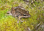 Frog in the camp Iwore
 -
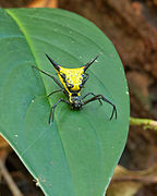 Spider on the slopes of the Ptarí tepui
 -
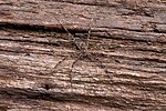 Spider river on a log
 -
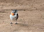 Zonotrichia capensis on top of Mount Roraima


Ethnic groups

The ethnicity of the Pemon is the largest group of indigenous people in the region. Are scattered throughout the Canaima National Park and are divided into three groups: Arekunas, Taurepanes and Kamarakotos. Most of them usually friendly, quiet and hardworking. They are the native inhabitants of the Gran Sabana and today have pervaded in tourism, manage and administer inns and serve as guides on expeditions in the region. Some can also speak English. Is not known exactly the number of native inhabitants of la Gran Sabana, however, the population census carried out by INE in 2001, revealed the presence of a total of 42,600 indigenous statewide Bolívar, of which the vast majority live in the Gran Sabana.
Languages
The language of almost all the Indians of the area is the Pemon, a language of Carib family related to the extinct and Tamanaco and Chaimas. Most of them also speak Spanish. However, note that there is a large non indigenous population that speaks Spanish. In Santa Elena de Uairén, in the area near the Brazilian border, is common to find people who speak Portuguese.
Towns and communities
Santa Elena de Uairén

As already mentioned, the main town is Santa Elena de Uairén, which is also the capital of the Gran Sabana Municipality. The city's name originated in the first daughter of the founder, Lucas Fernández Peña, called "Elena", and on the river that crosses the city, the "Uairén". It has an airport, a military post and is a free port from 1999, organized and founded by the son of the founder, Professor Héctor Fernández Espinoza. Its economy is based on trade and mining. Recently, the tourism sector has been an important development because of its proximity to the main natural features of the Gran Sabana and its location near the border. The city has introduced a rapid population growth during the last decade and it is estimated that by 2016 the population of the town is around 55,000. Several hotels that are involved in tourism with limited resources are spread through the center of the city. The Hotel Gran Sabana is a luxury option, like the Hotel Anaconda. In the center of the city can find many shops where it can buy supplies for camping in the national park, from canned or fresh food, to spare normal camping equipment. Many are also the business of buying and selling gold in the village.

Kavanayen
Kavanayen (Santa Teresita de Kavanayen) is an indigenous village inhabited mainly by the Pemon people. Currently it is estimated that about 30,000 people in the town. Is located within the boundaries of Canaima National Park in the Gran Sabana Municipality, in the Upper Caroní River. The Capuchin missionaries founded in 1943 Kavanayen. The buildings of the town are built with the technique developed by missionaries with stone taken from the area. One of the most important architectural attractions of the community, is the Shrine of Santa Teresita de Kavanayen, but it has other buildings of significant size and importance as a presidential residence where they usually stay for short periods the Presidents of the Republic of Venezuela, a beacon station, a generating turbine of hydroelectric power between others.
El Paují
The community of El Paují is located south of Bolivar State, about 75 km west of Santa Elena de Uairén, on the road that leads to Icabarú and very close to the border with Brazil. In El Paují the streets are not paved. Has power, but the build system is switched off shortly before midnight. Almost all households have its own generating plant. No cell phone service or coverage, but there is a communications center which it can access the internet. The community also has an airstrip, medications, a rescue group and a school. For tourists there are inns and eating places. In the community living around 500 people, many of them professionals and retirees. Among them there are craftsmen, adventurers, miners, beekeepers.
San Francisco de Yuruaní (Kumaracapai)

San Francisco de Yuruaní, indigenous community located in the "km 250" of the Troncal 10 is an important craft selling point scale, and refueling for tourists. The name in the native language of the community is Kumarakapay. The town offers various iconic pieces, including bracelets and necklaces. It can also find there the largest sample of mineral stones common in Bolivar state, as auriferous quartz, rose quartz, slate, iron, marble, bauxite, silicon, jet and ruffe, among others. In the restaurants of the community can sample typical foods. The small town has several services, including lodging at inns, selling groceries, restaurants, health, sale of crafts. It is also possible to organize trips and excursions to other parts of Canaima National Park.
Other communities
Among other less important communities may be mentioned San Rafael de Kamoirán, where are the Rapids Kamoirán, Wönken, known for its Capuchin missions, Paraitepuy of Roraima, where the walk starts normally to the tepui, and Iboriwo or Liwöriwö, where it can camp to visit the Aponwao Falls. Other sites, and located closer to Canaima area include Kavak, Kamarata, Pupurken, Guayaraca and Uruyén. These communities offer the possibility to the visitors of trekking in the area, or climbing Auyantepui being the pemones guides with extensive knowledge on the zone.
Tourism
Access and displacement in la Gran Sabana

To reach the Gran Sabana is necessary to pass the paved road (called Troncal 10) passing through Ciudad Guayana and reaches the Brazilian border. Just before arriving at the Gran Sabana is to pass the said place called La Escalera, an uphill road with several curves and immersed in a typically rainy and foggy forest. Once past that section there is a paved road that runs through the Gran Sabana. There are other ways to access other sites, but are not paved.
It can also take a plane to Santa Elena de Uairén. It can reach this town completely by paved road from Caracas, or from Brazil through Pacaraima, traveling along the highway BR174, which connects Manaus (some 1,000 km away from Santa Helena) and Boa Vista (approximately 225 km) with the Venezuela-Brazil border. Currently exists bus service between Ciudad Guayana and Santa Elena de Uairén, but it recommend car travel in order to make frequent stops in interesting places. The journey from Caracas is usually done in two days.
Some of the most attractive places reached only on four wheel drive vehicles (such is the case in places like Torón and Toroncito, Rapids Sakaika, Rapids Anaway, Rapids Käk, the town of Paraitepuy de Roraima, and several sites of interest in the way to Ikabarú).
.JPG?lang=en)
To reach the town of Kavak, where the gorge of the river of that name, it is essential to travel by air. In the second half of 2011, however, vehicles banned from some of the unpaved roads, such as at the River Torón. This measure was taken by the Government, because the soil condition was badly damaged by the passage of four wheel drive vehicles. The most important falls, and easier access on the main road, that can be reached without four wheel drive vehicles are the Falls Kama or "Kama-Merú" in Pemon language, Pacheco Creek or "Arapan-Merú" and Jasper Creek or "Kako Paru". Another issue to consider to move in the Gran Sabana is the supply of gasoline. There are few suppliers of fuel, and not everyone is always open. Most likely to find gasoline is in Santa Elena has Uairén, however, the town is over 200 km from the entrance to the Gran Sabana by La Escalera. For foreign tourists the fuel supply is not guaranteed, because the government guarantees gasoline only for Venezuelans. There is also differentiation of supply for Venezuelan tourists and local, due to smuggling of gasoline in Brazil has a much higher value than in Venezuela. The same problem of illegal purchase and sale of gasoline is before the entrance to the Gran Sabana, the Venezuelan side, in the town of San Isidro, also known as "Km 88".

It can lose hours to fill a vehicle fuel in high season. Because of these difficulties, it is recommended to tourists carry with pimpinas or drums (properly identified with the red color for security reasons).
Some tranches can be done in "curiaras", which are boats carved in wood, manned by local people. Despite being managed by pemones, these boats may have engines to reduce travel time. Such is the case of access to Falls Aponwao one of the most renowned for its majestic in the Gran Sabana, with a fall of about 110 meters. To get the fall is due to arrive by car to the camp Liwöriwö by ground road, and then take the curiara guided by Indigenous (a journey of about 20 minutes) until the fall.
Another high tourist activity, albeit at a price somewhat less accessible, is to fly by helicopter or plane. It can take flights from many places, however, the most common is to take off from Santa Elena de Uairén, where local agencies. Some plans include tours on tepuis Roraima and Kukenan, visits to waterfalls, overlooking Auyantepuy with overflight of Angel Falls and camp visits of Canaima, which is not accessible by vehicle.
Sites of interest
- Falls Aponwao (Chinak-meru)
- Falls Kamá (Kamá Meru)
- Falls Kamá (Kamá Mesalto)
- Falls Kawi (Kawí merú)
- Falls Kukenan
- Falls Yuruaní
- Falls Karuay
- La Laja
- El Paují
- El Abismo
- Santa Elena de Uairén
- Mission of Kavanayen
Photo Gallery
-
 A small lake of green water in the Km 88
 -
 Falls Kamá
 -
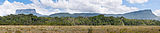 Panoramic view of the tepuis Ptarí and Sororopán
 -
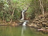 Well in Jasper Creek II
 -
 Typical landscape
 -
 Last rays of the setting sun on the wall of the tepui Kukenan
 -
 Stone of the Virgin
 -
 Tepuy at sunset
 -
 Mount Roraima from Tëk River Camp
 -
 Kukenan
 -
 Overview of tepuis from Kavanayen
 -
 Upper Falls Aponwao


