Gran Sabana: Difference between revisions
No edit summary |
No edit summary |
||
| Line 17: | Line 17: | ||
The largest city in the area is [[Santa Elena de Uairén]]. Has experienced very rapid growth, with a population of over 30,000 habitantes. It was founded in 1923 by Lucas Fernández Peña, attracted by the growth of diamonds in the area. Its average temperature is between 25 and 28 ° C. It is located at 910 meters above sea level, is 15 km from the border with Brazil, 615 km from [[Ciudad Guayana]], and about 1,400 km from [[Caracas]], paved road. The total population of the Gran Sabana is currently estimated at about 48,000 habitantes. |
The largest city in the area is [[Santa Elena de Uairén]]. Has experienced very rapid growth, with a population of over 30,000 habitantes. It was founded in 1923 by Lucas Fernández Peña, attracted by the growth of diamonds in the area. Its average temperature is between 25 and 28 ° C. It is located at 910 meters above sea level, is 15 km from the border with Brazil, 615 km from [[Ciudad Guayana]], and about 1,400 km from [[Caracas]], paved road. The total population of the Gran Sabana is currently estimated at about 48,000 habitantes. |
||
==Geography== |
|||
As mentioned above, the Gran Sabana is a park with unique characteristics. The beauty of the landscape is accentuated in the [[Guiana Shield]], the oldest geological formation of the earth. It consists of two main geological formations, an [[igneous]] [[metamorphic]] age of approximately 2,000 million years and a layer of sedimentary rocks, [[sandstones]] of the Roraima formation, deposited makes about 1,700 million years. These sandstones sedimented in a lake or ocean, reaching thicknesses of several kilometers. Were originally united in one or more plates with some linearity, but were fractured and eroded over hundreds of millions of years. During these eras were alternated [[humid]] and [[warm]] climates. This region was subjected to several periods of [[Tectonic uplift|uplift]] and subsidence [[Plate tectonics|tectonics]], and because of this, certain areas of the shield were more prone to erosion than others. This determined the presence of large sandstone beds are isolated, called "tepuis" in the language of the indigenous inhabitants of the region. The relief of the region is slightly wavy. The average height is about a thousand feet high, but it can vary considerably over short distances: the road of [[El Dorado]] to Santa Elena de Uairén is of 200 meters to 1,500 in less than 30 km, in a place called "La Escalera", a raise with a paved street. Its condition of savanna is not due to climate (which is enough rain to support a forest vegetation), but the formation of rocky and sandy soils, although parts of the [[jungle]] can be seen in some depressions and, above all, forests gallery along the rivers. |
|||
[[File:360_Panoramic_view_from_Kavanayen_-_Canaima_National_Park.jpg|thumb|center|800px|360 degree panoramic view of a typical landscape of the Gran Sabana]] |
|||
===Hydrography=== |
|||
La Gran Sabana, and the rest as Venezuela in general, is rich in river networks. The main [[Drainage basin|drainage sub-basins]] are formed by the rivers Yuruaní, Aponwao, Kukenán, Suruku, Ikabarú, Karuay, Urimán and Antabare. |
|||
[[File:Yuruani_tepuy_y_rio_-_Gran_sabana.jpg|thumb|250 px|left|Yuruaní River, with the tepui of same name at the bottom]] |
|||
Note that the Caroní River, of 925 km in length, and flow rate equal to 5000 m³/s, from which Venezuela gets most of its [[Electric power|electricity]] by [[Hydroelectricity|hydropower]] exploitation with, originates from several tributaries coming from tepuis and mountains of the Gran Sabana, as the Aponwao, the Yuruaní and the Kukenan. The vast majority of rivers and streams in the region are of dark waters, with coloration similar to that of tea. The waters are very poor in dissolved nutrients and rich in humic acids and tannins, which give them its characteristic brown color. The acidity is quite high, reaching PH3-4, and although this may cause acidity in visitors that taste first these waters, it can say that these are among the least polluted waters in the world. As to tourist interest, the rivers are of great importance, as visitors who travel the roads of the Gran Sabana usually use for recreation, swimming, and camping. These are usually easily accessible and that the entries are found throughout the main road, and many are arranged with steps for easy access. At several points, the Pemones offer guidebooks and/or ask for contributions of money in exchange for keeping clean areas. |
|||
=== Tepuys === |
|||
In the Gran Sabana is randomly distributed ancient massifs eroded in tabular form, known as tepuis, examples of inverted relief, which form a kind of typical plateaus of the Guiana highlands. These plateaus, in the Gran Sabana, reach its maximum altitude in the [[Mount Roraima|Tepui Roraima]], with nearly 2,800 meters above sea level. |
|||
====Auyantepui==== |
|||
Although the Auyantepui not part of the Gran Sabana as the exact delimitation of the territory, is considered by many to be part of it, being the most famous tepui throughout Guiana. It is located in Canaima Northwest and is one of the most recognized tepuis in the world, because it comes from the highest waterfall in the world, the Angel Falls (named for the local indigenous "Karepacupai-merú") with almost 979 meters fall libre. |
|||
[[File:Auyan Tepui 01.JPG|thumb|250 px|left|The Auyantepui from Camp Uruyén]] |
|||
This Falls was discovered by the explorer aviator [[Jimmy Angel]] in 1937. It attempted to land his plane on top of Auyantepui, crashing (without fatalities) in one of his expeditions. Is the second largest Guiana tepui, with its surface of 700 km ², after Chimantá. It has an altitude of 2,535 meters. The Auyantepui is inclined on its surface: on the southern edge exceeds 2,400 meters, while the northern edge of 1,600 barely meters. |
|||
It can access the southern part of Auyantepui and climb. In some sections of the trip is necessary to use ropes to climb, although the difficulty level is not high. To make the ascent to the tepui is necessary to reach the village of Kavak by plane or helicopter, as there is no vehicle access routes to the tepui. |
|||
===Chimantá Massif=== |
|||
[[File:Cueva Charles Brewer.jpg|thumb|160px|Interior Charles Brewer Cave in Chimantá]] |
|||
The Chimantá Massif is the formation of plateaus (10 in total, among which Amurí, Churí, and Akopán-tepui) largest in all of Venezuela, with its 1,470 km ². The tepui is not easily accessible, and is not visited by tourists. It is located in the central-western Canaima. Recently, the Venezuelan scientist [[Charles Brewer Carías]], flying over the massif discovered a huge cave entrance to a 250 meters high. From this observation had two expeditions, one of which found the same Brewer Carías, among many other innovations, a new species of frog, named in his honor [[Colostethus breweri]]. |
|||
===Mount Roraima=== |
|||
[[File:Roraima3 (79).JPG|thumb|left|250px|Mount Roraima clear, rare event]] |
|||
It is the highest tepui of the National Park. It is also known as Blue Mountain or Crystal Mountain, and is considered by the local Indians as a divinity. The Pemon believe that most tepuis host powerful spirits or entities to which they respect and fear. Some of them even make offerings and prayers at the top in her infrequent visits to the tepui (usually as tourist guides in exchange for money and/or food. Its height is about 2,800 meters, covers an area of 15 km long and its surface is 200 km ². Its walls, completely vertical, may reach 500 meters high. |
|||
[[File:Roraima Elefante.jpg|thumb|right|160px|Rock formation of the "Elephant" at the top of Mount Roraima]] |
|||
Despite this, over this wall, is an outstanding area, with tilt and space for tourists to climb to the top. Among the attractions are the Valley of the crystals (a deposit of quartz formations), the Jacuzzi area (where water wells of greenish-yellow color), the viewpoints of La Ventana and El Abismo, the North Mazes, la Proa, Lake Gladys, and the "Triple Point". This point is located in the northeast of the tepui, and is the place where it meets the border between Brazil, Venezuela and Guyana. Are also very attractive rock formations eroded by wind, leading to myriad interpretations of figures , as the formations of the "flying turtle", the "Mexican hat", the "monkey eating an ice cream cone," or the "elephant", shown in the image. |
|||
===Kukenan (Matawi-tepui)=== |
|||
Incorrectly named and widely known as Kukenan-tepui, this plateau is real called Matawi-tepui. It has a height of 2,680 meters and was first climbed in 1963. This expedition was organized by the [[Bangor University|University of Bangor]], [[England]]. The Matawi-Tepui chain belongs to the eastern tepuis of the Gran Sabana, along with the Yuruani-tepui. Also born the [[Cuquenan Falls|Kukenan Falls]] listed as the tenth highest waterfall in the world with its 629 meters of free fall. |
|||
[[File:Kukenan Tepuy at Sunset.jpg|thumb|center|500px|The majesty of Tepuy [[Kukenan]] or Matawi-tepui, viewed from the Tek River Base Camp, 1,100 m]] |
|||
===Other tepuis=== |
|||
Other recognized tepuis are in the chain Ilú-Tramén-Karaurín, as well the Wadaka-piapó (or Wadakapiapü) and the Yuruaní, which together with the Kukenan and Roraima, in the chain of the 7 eastern tepuis. These also highlight the tepuys Iglú-tepui, Ptarí-tepui, Acopán-tepui and the Sororopán-tepui, which has a tilt feature, and can be climbed. There are a large number of minor tepuis, however, can be found tepuis along the whole of Canaima, the total of these around 150. Most tepuis reach heights ranging between 2,000 to 2,700 m. |
|||
<div class="center"><gallery> |
|||
File:Tepuy_Gran_Sabana.jpg|Ptarí-tepui |
|||
File:Tramen Ilu Karaurin tepuys.jpg|Tepuys Ilú, Tramén and Karaurín |
|||
File:Wadakapiapo Yuruani tepuy 2010.jpg|Tepuys Wadaka-piapó and Yuruaní |
|||
File:Mona tepui.jpg|Moná-tepui |
|||
File:Chiricayen.jpg|Tepuy Chiricayen |
|||
</gallery></div> |
|||
==Flora and fauna== |
==Flora and fauna== |
||
Revision as of 19:26, 4 August 2012

La Gran Sabana (Spanish pronunciation: [la ɣɾan saˈβana], English: The Great Savanna), also known as Guianan savanna, is a region located in southeastern Venezuela, in the Guiana Highlands, also south-east in Bolívar State, and extending until the border with Brazil and Guyana. The Gran Sabana has 10,820 km ² and is part of one of the largest National Parks in Venezuela, the Canaima National Park. The average temperature is around 20 º C, but at night can drop to 13 ° C, and in some of the most elevated sites, depending on weather, may fall a bit more. The location offers unique landscapes around the world, has rivers, waterfalls and gorges, deep and vast valleys, impenetrable jungles, and savannahs that host a large number and variety of plant species, a diverse fauna, and the plateaus better known as tepuis.
History

During the time of the Conquest and Colonization, the extent of the territories of Guiana and its natural resources gave rise to the legend of El Dorado, which caught the attention of adventurers, explorers and settlers. They eventually came to these shores in search of gold, gems and other valuable products. Thus began the exploration of a territory so vast and difficult to access, which to date has several areas that nobody has come.
Due to the richness and diversity, both biological and mineral and geographical of Southeast Guayana, was necessary to protect the territory by the Government of Venezuela. For this reason, Canaima was declared National Park, many years later by Executive Order No. 770 dated June 12, 1962. The park is the second largest of country.
The Canaima National Park now covers an area of about three million hectares (about 30,000 km ²), which places him among the six largest national parks in the world. However, its original area was of one million hectares, and did not include the territory of the Gran Sabana.

It was enlarged in 1975 to cover several points of high ecological importance. Among those sites are: Carrao River Basin, the headwaters of the Caroní River, the Sierra de Lema, the source of the Cuyuni River and the rolling plains, which form the Gran Sabana. Currently, the territory of the Gran Sabana is of 1,082 000 hectares, as shown in the image of the park entrance sign.
Currently, the Gran Sabana remains a place of high ecological value, not only for UNESCO, proclaimed World Heritage Site in 1994 to give that title to Canaima National Park, but also to the Government, which promotes conservation and exploration, and for the people of Venezuela: Thousands of tourists visit the place every year. They can enjoy the variety of natural wonders in the park and delight both for the beauty of its places of interest (his only relief, shaped landscapes of the tepuis, waterfalls and streams), and its diversity of fauna and flora. The latter attract many scholars and scientists from around the world. Only in the Gran Sabana is 40% of the species of Venezuela, and 23% in terms of reptiles and amphibians, with many endemic species.
The largest city in the area is Santa Elena de Uairén. Has experienced very rapid growth, with a population of over 30,000 habitantes. It was founded in 1923 by Lucas Fernández Peña, attracted by the growth of diamonds in the area. Its average temperature is between 25 and 28 ° C. It is located at 910 meters above sea level, is 15 km from the border with Brazil, 615 km from Ciudad Guayana, and about 1,400 km from Caracas, paved road. The total population of the Gran Sabana is currently estimated at about 48,000 habitantes.
Geography
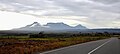
As mentioned above, the Gran Sabana is a park with unique characteristics. The beauty of the landscape is accentuated in the Guiana Shield, the oldest geological formation of the earth. It consists of two main geological formations, an igneous metamorphic age of approximately 2,000 million years and a layer of sedimentary rocks, sandstones of the Roraima formation, deposited makes about 1,700 million years. These sandstones sedimented in a lake or ocean, reaching thicknesses of several kilometers. Were originally united in one or more plates with some linearity, but were fractured and eroded over hundreds of millions of years. During these eras were alternated humid and warm climates. This region was subjected to several periods of uplift and subsidence tectonics, and because of this, certain areas of the shield were more prone to erosion than others. This determined the presence of large sandstone beds are isolated, called "tepuis" in the language of the indigenous inhabitants of the region. The relief of the region is slightly wavy. The average height is about a thousand feet high, but it can vary considerably over short distances: the road of El Dorado to Santa Elena de Uairén is of 200 meters to 1,500 in less than 30 km, in a place called "La Escalera", a raise with a paved street. Its condition of savanna is not due to climate (which is enough rain to support a forest vegetation), but the formation of rocky and sandy soils, although parts of the jungle can be seen in some depressions and, above all, forests gallery along the rivers.

Hydrography
La Gran Sabana, and the rest as Venezuela in general, is rich in river networks. The main drainage sub-basins are formed by the rivers Yuruaní, Aponwao, Kukenán, Suruku, Ikabarú, Karuay, Urimán and Antabare.

Note that the Caroní River, of 925 km in length, and flow rate equal to 5000 m³/s, from which Venezuela gets most of its electricity by hydropower exploitation with, originates from several tributaries coming from tepuis and mountains of the Gran Sabana, as the Aponwao, the Yuruaní and the Kukenan. The vast majority of rivers and streams in the region are of dark waters, with coloration similar to that of tea. The waters are very poor in dissolved nutrients and rich in humic acids and tannins, which give them its characteristic brown color. The acidity is quite high, reaching PH3-4, and although this may cause acidity in visitors that taste first these waters, it can say that these are among the least polluted waters in the world. As to tourist interest, the rivers are of great importance, as visitors who travel the roads of the Gran Sabana usually use for recreation, swimming, and camping. These are usually easily accessible and that the entries are found throughout the main road, and many are arranged with steps for easy access. At several points, the Pemones offer guidebooks and/or ask for contributions of money in exchange for keeping clean areas.
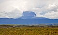
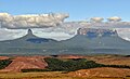
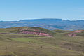
Tepuys
In the Gran Sabana is randomly distributed ancient massifs eroded in tabular form, known as tepuis, examples of inverted relief, which form a kind of typical plateaus of the Guiana highlands. These plateaus, in the Gran Sabana, reach its maximum altitude in the Tepui Roraima, with nearly 2,800 meters above sea level.
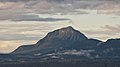
Auyantepui
Although the Auyantepui not part of the Gran Sabana as the exact delimitation of the territory, is considered by many to be part of it, being the most famous tepui throughout Guiana. It is located in Canaima Northwest and is one of the most recognized tepuis in the world, because it comes from the highest waterfall in the world, the Angel Falls (named for the local indigenous "Karepacupai-merú") with almost 979 meters fall libre.

This Falls was discovered by the explorer aviator Jimmy Angel in 1937. It attempted to land his plane on top of Auyantepui, crashing (without fatalities) in one of his expeditions. Is the second largest Guiana tepui, with its surface of 700 km ², after Chimantá. It has an altitude of 2,535 meters. The Auyantepui is inclined on its surface: on the southern edge exceeds 2,400 meters, while the northern edge of 1,600 barely meters.
It can access the southern part of Auyantepui and climb. In some sections of the trip is necessary to use ropes to climb, although the difficulty level is not high. To make the ascent to the tepui is necessary to reach the village of Kavak by plane or helicopter, as there is no vehicle access routes to the tepui.
Chimantá Massif
The Chimantá Massif is the formation of plateaus (10 in total, among which Amurí, Churí, and Akopán-tepui) largest in all of Venezuela, with its 1,470 km ². The tepui is not easily accessible, and is not visited by tourists. It is located in the central-western Canaima. Recently, the Venezuelan scientist Charles Brewer Carías, flying over the massif discovered a huge cave entrance to a 250 meters high. From this observation had two expeditions, one of which found the same Brewer Carías, among many other innovations, a new species of frog, named in his honor Colostethus breweri.
Mount Roraima
.JPG?lang=en)
It is the highest tepui of the National Park. It is also known as Blue Mountain or Crystal Mountain, and is considered by the local Indians as a divinity. The Pemon believe that most tepuis host powerful spirits or entities to which they respect and fear. Some of them even make offerings and prayers at the top in her infrequent visits to the tepui (usually as tourist guides in exchange for money and/or food. Its height is about 2,800 meters, covers an area of 15 km long and its surface is 200 km ². Its walls, completely vertical, may reach 500 meters high.

Despite this, over this wall, is an outstanding area, with tilt and space for tourists to climb to the top. Among the attractions are the Valley of the crystals (a deposit of quartz formations), the Jacuzzi area (where water wells of greenish-yellow color), the viewpoints of La Ventana and El Abismo, the North Mazes, la Proa, Lake Gladys, and the "Triple Point". This point is located in the northeast of the tepui, and is the place where it meets the border between Brazil, Venezuela and Guyana. Are also very attractive rock formations eroded by wind, leading to myriad interpretations of figures , as the formations of the "flying turtle", the "Mexican hat", the "monkey eating an ice cream cone," or the "elephant", shown in the image.
Kukenan (Matawi-tepui)
Incorrectly named and widely known as Kukenan-tepui, this plateau is real called Matawi-tepui. It has a height of 2,680 meters and was first climbed in 1963. This expedition was organized by the University of Bangor, England. The Matawi-Tepui chain belongs to the eastern tepuis of the Gran Sabana, along with the Yuruani-tepui. Also born the Kukenan Falls listed as the tenth highest waterfall in the world with its 629 meters of free fall.

Other tepuis
Other recognized tepuis are in the chain Ilú-Tramén-Karaurín, as well the Wadaka-piapó (or Wadakapiapü) and the Yuruaní, which together with the Kukenan and Roraima, in the chain of the 7 eastern tepuis. These also highlight the tepuys Iglú-tepui, Ptarí-tepui, Acopán-tepui and the Sororopán-tepui, which has a tilt feature, and can be climbed. There are a large number of minor tepuis, however, can be found tepuis along the whole of Canaima, the total of these around 150. Most tepuis reach heights ranging between 2,000 to 2,700 m.
-
 Ptarí-tepui
 -
 Tepuys Ilú, Tramén and Karaurín
 -
 Tepuys Wadaka-piapó and Yuruaní
 -
 Moná-tepui
 -
 Tepuy Chiricayen


Flora and fauna
The area contains a number of unique plant species that have adapted to the specific and sometimes harsh environment of the area.
Access
To get to la Gran Sabana by road one must go by the tarmac road from El Dorado to Brazil. Alternatively, one can fly to Santa Elena de Uairen. To access the best attractions, one would take a 4x4. Kavak can only be reached by air.