Concepción, Chile: Difference between revisions
m r2.7.2) (Robot: Removing bo:ཀོན་སེབ་སི་ཡོན། (ཅི་ལི།), bpy:Concepción |
|||
| Line 272: | Line 272: | ||
|Image:Biobus01.jpg|BioBus, transport to a train station |
|Image:Biobus01.jpg|BioBus, transport to a train station |
||
|Image:Hotel El Araucano.JPG|Hotel Araucano |
|Image:Hotel El Araucano.JPG|Hotel Araucano |
||
|File:Escultura en UConce.jpg|Sculpture ''Homage to the spirit of the founders of the University of Concepción'' |
|||
|File:C. Dinosaurio3.JPG|C. Dinosaurio3|Diplodocus in the Jurassic Park of the Plaza Acevedo. |
|||
|File:Detalle mural Precencia de América Latina.jpg|Entrance Casa del Arte together with the mural ''[[Presencia de América Latina]]''. |
|||
|Image:Plaza de Armas Concepción.jpg|''Plaza de la Independencia'', the [[Plaza de Armas]] of Concepcion |
|Image:Plaza de Armas Concepción.jpg|''Plaza de la Independencia'', the [[Plaza de Armas]] of Concepcion |
||
|File:Parque Ecuador.jpg|View of Ecuador Park, on the slopes of [[Cerro Caracol]]. |
|||
|File:Lagunalomendez.jpg|[[Lo Méndez Lagoon]]. |
|||
}} |
}} |
||
Revision as of 18:04, 11 January 2012
This article needs additional citations for verification. (September 2010) |
You can help expand this article with text translated from the corresponding article in Spanish. (February 2010) Click [show] for important translation instructions.
|
Concepción
La Concepción de María Purísima del Nuevo Extremo (original name) | |
|---|---|
 Flag .svg?lang=en) Seal | |
| Nickname: Biobío's Pearl | |
| Motto(s): La Capital del Sur de Chile The Capital of the South of Chile | |
 Location in the Biobío Region | |
| Country | Chile |
| Region | Biobío |
| Province | Concepción |
| Founded | October 5, 1550 |
| Founded by | Pedro de Valdivia |
| Government | |
| • Type | Municipality |
| • Alcalde | Patricio Kuhn Artigues (2008-2012) (UDI) |
| Area | |
| • City and Commune | 222 km2 (86 sq mi) |
| Population (2006) | |
| • City and Commune | 292,589 |
| • Density | 1,318/km2 (3,410/sq mi) |
| • Metro | 1,322,581 |
| Demonym | Penquista |
| Time zone | UTC−4 (CLT) |
| • Summer (DST) | UTC−3 (CLST) |
| Post code | 3349001 |
| Telephone prefix | 56 + 41 |
| Website | Municipality of Concepción |
Concepción () is a city in Chile, capital of Concepción Province and of the Biobío Region or Region VIII. Greater Concepción (Gran Concepción, including Talcahuano, San Pedro de la Paz, Hualpén, Chiguayante, Penco, Tomé, Lota, Coronel, Hualqui and Concepción) is the second-largest conurbation in the country, with 889,725 inhabitants (2002 census). Individually, it is the 11th largest commune in the country, with a population of 212,003.
History
.jpg?lang=en)
Concepción was founded by Pedro de Valdivia[FN 1] in 1550 north of the Bío-Bío River, at the site which is today known as Penco. At that time it was given the name Concepción del Nuevo Extremo. The new settlement of Concepción was just a few kilometers north of La Frontera (The Frontier), the boundary between Spanish territory and the land of the Mapuche, an American Indian ethnic group that remained independent until the 1870s. The settlement was formally recognized by the Spanish authorities as a town two years later by a royal decree. It was given a coat-of-arms that is still in use today.
Although Concepción was a significant military settlement for the Captaincy-General of Chile, it was overrun and destroyed by Mapuche armies in 1554, and once again after being refounded in 1555. Concepción was restored during the governorship of García Hurtado de Mendoza when he landed there and built a fort on the Alto de Pinto in 1557. The town was refounded once more on January 6, 1558, by captain Jerónimo de Villegas. It became the headquarters of the military forces engaged against the Mapuche in Araucanía over the next two centuries, growing to a population of 10,000 despite a siege in 1564 and other attacks by the Mapuche. Concepción was the home of the Real Audiencia from 1565 to 1575.
Earthquakes and tsunamis, which razed the town in 1570, 1657, 1687, 1730 and 1751, led the authorities to move the town to its current site in the Valle de la Mocha, alongside the Bío-Bío River; the old site lay empty until March 29, 1842, when the present town of Penco was founded.
The new site for the town of Concepción became the main town of the Intendancy of Concepción, whose jurisdiction extended from the Maule River to La Frontera. The first Intendant of Concepción was the Irishman Ambrose O'Higgins, Marquis of Osorno, who later became Royal Governor of Chile and Viceroy of Peru.
When the First National Government Board met in Santiago on September 18, 1810, citizens of Concepción joined up. Concepción was used as the point of entry by the Spanish Army in the attempt by the Viceroyalty of Peru to re-conquer Chile. Concepción politicians and soldiers became a significant political force in the newly-independent country.
On January 1, 1818, Ambrose O'Higgins's son, Bernardo O'Higgins, proclaimed and took the oath of the Chilean War of Independence in the main square of Concepción, which since then has been known as "Plaza de la Independencia". On February 20, 1835, the town again was largely destroyed by an earthquake and had to be rebuilt.
As of 2010, Concepción is the second largest city of Chile. The Universidad de Concepción, founded in 1919, became the first private university in Chile. The neighboring harbor of Talcahuano is the site of the largest naval base in Chile.
27 February 2010 earthquake
This section needs expansion. You can help by adding to it. (March 2010) |

On February 27, 2010, an 8.8 magnitude earthquake struck the city of Concepción, killing more than 521 people and injuring thousands nationwide. Following the earthquake, geologists relying on global positioning satellite (GPS) data concluded that the city had been displaced roughly 3 meters (10 feet) to the west as a result of the event.[2] Fortunately, the city avoided the tsunami that followed the earthquake.[3]
After the 2010 Chile earthquake, a prison riot began in Concepción's El Manzano prison following a failed escape attempt by the internees. Different parts of the prison were set on fire and the riot was controlled only after the guards shot into the air and received help from military units.[4] As of 5 March 2010, a Peruvian field hospital has been deployed to the city.[5]
Seismology
Like all of Chile, the Concepción region is seismically active, with much of Concepción destroyed by a violent earthquake in 1939. Another major earthquake in 1960 had a nearby epicenter.[FN 2]
On February 27, 2010, an earthquake of 8.8 magnitude struck at 35.846°S, 72.719°W, 115 km (71 mi) NNE of the city. The United States Geological Survey said the earthquake struck at 0334 GMT on Saturday at a depth of 35 km (22 mi). The effects were felt as far away as São Paulo, Brazil—2,870 miles (4,620 km).
Climate
The climate of Concepción is classified as Köppen climate classification Csb, with a dry summer nadir in February. Despite the Csb classification, the climate is generally considered oceanic, because for most of the year it resembles an oceanic climate. The climate's oceanic influence keeps temperatures mild throughout the year. Temperatures rarely exceed 30 °C (86 °F) or fall below −3 °C (26.6 °F). In the five-month period between May and October, the city receives approximately 83% of it's total annual precipitation, which totals 1,110 mm (44 in). The wettest month since records began in 1912 was June 2000 with 561 millimetres (22.1 in)[6]
| Climate data for Concepcion (Carriel Sur), Chile | |||||||||||||
|---|---|---|---|---|---|---|---|---|---|---|---|---|---|
| Month | Jan | Feb | Mar | Apr | May | Jun | Jul | Aug | Sep | Oct | Nov | Dec | Year |
| Mean daily maximum °C (°F) | 22.8 (73.0) |
22.4 (72.3) |
20.9 (69.6) |
18.4 (65.1) |
15.6 (60.1) |
13.4 (56.1) |
13.0 (55.4) |
13.8 (56.8) |
15.1 (59.2) |
16.8 (62.2) |
19.2 (66.6) |
21.5 (70.7) |
17.7 (63.9) |
| Daily mean °C (°F) | 16.3 (61.3) |
15.7 (60.3) |
13.9 (57.0) |
12.0 (53.6) |
10.8 (51.4) |
9.2 (48.6) |
8.8 (47.8) |
9.1 (48.4) |
9.7 (49.5) |
11.5 (52.7) |
13.5 (56.3) |
15.5 (59.9) |
12.2 (54.0) |
| Mean daily minimum °C (°F) | 10.5 (50.9) |
10.2 (50.4) |
8.9 (48.0) |
7.5 (45.5) |
7.4 (45.3) |
6.2 (43.2) |
5.7 (42.3) |
5.6 (42.1) |
5.6 (42.1) |
6.8 (44.2) |
8.3 (46.9) |
9.9 (49.8) |
7.7 (45.9) |
| Average rainfall mm (inches) | 21.0 (0.83) |
14.6 (0.57) |
24.9 (0.98) |
56.0 (2.20) |
175.9 (6.93) |
218.2 (8.59) |
222.1 (8.74) |
153.2 (6.03) |
87.6 (3.45) |
64.9 (2.56) |
41.1 (1.62) |
28.2 (1.11) |
1,107.7 (43.61) |
| Source: Meteorología Interactiva[7] | |||||||||||||
Demographics
| Year | Population | Reference |
|---|---|---|
| 2012 | 229,684 | [8] |
| 2006 | 225,158 | [8] |
| 2002 | 216,061 | [9] |
| 1992 | 326,784 | [10] |
| 1982 | 267,891 | [10] |
| 1970 | 161,006 | [10] |
According to data collected on 2002 in the Census of the National Institute of Statistics, the township has an area of 221.6 km2 (86 sq mi) and a population of 216,061 inhabitants, of whom 103,860 are men and 112,201 are women.
Conception is home to 11.61% of the total population of the region. 1.88% (4,058 persons) is for rural population and 98.12% (212,003) to urban population.
Between 1970 and 1982 there is a large increase in the population. One reason is the inclusion of San Pedro, segregated from the municipality of Coronel.
The Concepción commune population declined sharply because in 1996 it was divided, creating Chiguayante and San Pedro de la Paz. In these communes the population has grown quickly since they have become bedroom communities of Concepción, i.e. residential cities that do not have a center with many shops, such as Concepcion.
It is projected that by 2009 an estimated population of 227,768 inhabitants live in the commune.[8]
There is a significant percentage of foreign residents in the city, the most numerous are the Spanish, Italian and U.S. expatriate communities. Also are smaller segments of German, French, British, Dutch, Greek, Portuguese, Croatian, Scandinavian, Arab and Australian descendants in a city settled by waves of immigration.
Cultural life
To an outsider, there may be confusion between the demonyms of the inhabitants of Concepción and the nearby city of Penco. Due to the previous location of Concepción being where Penco currently stands, inhabitants of Concepción are called penquistas while inhabitants of Penco are known as pencones.
Concepción is one of the most active cities in Chilean rock music and many famous rock groups in Chile started up in Concepción. Concepción has the second largest concentration of universities in Chile, and is home to three major universities. Concepción currently has four traditional universities:
- Universidad de Concepción
- Universidad Católica de la Santísima Concepción
- Universidad Técnica Federico Santa María
- Universidad del Bío-Bío
Sports
Concepción is home of three professional football teams:
- Club Deportivo Universidad de Concepción, currently in the Chilean top division, Liga Chilena de Fútbol: Primera División
- Club Deportivo Ferroviario Almirante Arturo Fernández Vial, currently in the Chilean third division, Tercera A
- Club de Deportes Concepción, currently in the second division, Liga Chilena de Fútbol: Primera B
Basketball is also played at a high professional level. The most notable team is:
- Club Deportivo Universidad de Concepción, currently in DIMAYOR, División Mayor del Básquetbol de Chile
Economy

Historically characterized by a strong manufacturing industry, Concepión has also been a major center for distribution and services and the financial basis of the regional economy.
Trade in the city is concentrated in the Plaza Independencia (Independence Square), the pedestrian street Alonso de Ercilla y Zúñiga (built in 1981), and along the major avenues. One such avenue is the Diego Barros Arana street which has developed into the commercial center of the city and the region was until 1907 even known as "calle Comercio" ("Commerce Street"). New commercial centers are being developed around the old central station and the new civic district as a part of the Chilean bicentennial (September 18, 2010). A considerable percentage of local trade is taking place in settlements around the city.
Administration
As a commune, Concepción is a third-level administrative division of Chile administered by a municipal council, headed by an alcalde who is directly elected every four years. The municipal building (alcaldía) is located at O'Higgins Nº 525 36°49′41.50″S 73°03′04.93″W / 36.8281944°S 73.0513694°W.[11] The 2008-2012 alcalde is Patricio Kuhn Artigues (UDI). The communal council has the following members:[1]
- Alvaro Ortiz Vera (PDC)
- Rodrigo Díaz Wörner (PDC)
- Christian Paulsen Espejo-Pando (RN)
- Escequiel Riquelme Figueroa (Ind.)
- Fernando Gonzalez Sánchez (UDI)
- Alejandra Smith Becerra (PDC)
- Patricio Lynch Gaete (UDI)
- Jorge Condeza Neuber
Within the electoral divisions of Chile, Concepción is represented in the Chamber of Deputies by José Miguel Ortiz (PDC) and Enrique Van Rysselberghe (UDI) as part of the 44th electoral district, (together with San Pedro de la Paz and Chiguayante). The commune is represented in the Senate by Alejandro Navarro Brain (MAS) and Hosain Sabag Castillo (PDC) as part of the 12th senatorial constituency (Biobío-Cordillera).
Notable citizens
- Enrique Molina Garmendia - Founder of university of Concepción, one of the top universities in Chile.
- Luis Altamirano - President of the 1924 Government Junta of Chile
- Graciela Araya - opera singer
- José María de la Cruz - Soldier
- Adrián García - Tennis player
- Lisando Henríquez - Footballer
- Ignacio Urrutia Manzano - Politician
- Adelqui Migliar - Film actor, director, writer and producer
- Marco Enriquez Ominami - Politician
- José A. Santos - Retired American jockey
- Paulina Veloso - Lawyer and Socialist Party politician
- Aníbal Zañartu - Politician
Twin cities
This article needs additional citations for verification. (April 2011) |
About eight or nine cities have sister city associations, including one in the USA.
 - Cascavel, Brazil
 - Bethlehem, Palestinian National Authority
 - Guayaquil, Ecuador
 - Rosario, Argentina
- - La Plata, Argentina
 - Auckland, New Zealand
 - Sucre, Bolivia
 - Caracas, Venezuela
 - Palm Desert, California.
Gallery
-
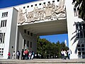 Arco de Medicina ("Arch of Medicine"), on the campus of the Universidad de Concepción
 -
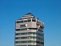 Andes Tower
 -
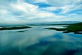 Mouth of the Bío-Bío River emptying into the Pacific Ocean
 -
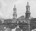 Cathedral of Concepción; it was demolished after an earthquake in 1939
 -
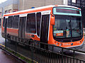 BioBus, transport to a train station
 -
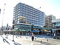 Hotel Araucano
 -
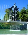 Sculpture Homage to the spirit of the founders of the University of Concepción
 -
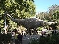 C. Dinosaurio3
 -
File:Detalle mural Precencia de América Latina.jpg


References
- Ida Stevenson Weldon Vernon (1969) Pedro de Valdivia, Conquistador of Chile, Greenwood Press
- John Milton Nickles, Marie Siegrist (1965) Bibliography and Index of Geology Exclusive of North America, Geological Society of America, v.28
Line notes
Citations
- ^ a b Template:Es "Municipality of Concepción". Retrieved 3 September 2010.
- ^ CNN, "Chile quake moves city more than 10 feet", "9 March 2010" (accessed 10 March 2010)
- ^ Time Magazine, "Quake Response Doesn't Live Up to Chile's Self-Image", Eben Harrell, 4 March 2010 (accessed 4 March 2010)
- ^ El Mercurio, March 1. Cuerpo C, page C13
- ^ UKPA, "Foreign hospitals help out Chile", 6 March 2010 (accessed 6 March 2010)
- ^ Climate explorer for Concepción
- ^ "Información climatológica de estaciones chilenas".
- ^ a b c Projections by the INE.
- ^ According to Census 2002, operated by the INE. Note that the agency's projections indicate that 2006 the estimated population of 225,158 inhabitants.
- ^ a b c According to Last 5 census, the INE
- ^ Template:Es "Government of Chile: SUBDERE - Alcaldes and Councilors". Retrieved 18 September 2010.
External links
- Concepción municipality Template:Es icon
- El Sur, newspaper of Concepción Template:Es icon
- Viveconce, Event schedule of Concepción Template:Es icon
- Octava, Website directory Template:Es icon
- HelloChile - Spanish tutoring and tourism in and around the city of Concepción, Information in English about the Chilean life and places to visit Template:En icon
- Template:Wikitravel Template:En icon
