Cusco: Difference between revisions
No edit summary |
|||
| Line 370: | Line 370: | ||
[[File:82 - Cuzco - Juin 2009.jpg|thumb|center|815px|<center>The Plaza de Armas of the city of Cuzco, Peru at night.</center>]] |
[[File:82 - Cuzco - Juin 2009.jpg|thumb|center|815px|<center>The Plaza de Armas of the city of Cuzco, Peru at night.</center>]] |
||
==Population== |
|||
Until the late 18th century Cuzco was the most populous city in the continent, even more than Lima. But because of the great revolution of Túpac Amaru in 1780, the white population migrated to Arequipa considered as the most secure and safe from a possible new uprising. So to the 20th century the population was largely mestizo and indigenous, but now the white population has grown significantly in the city as high as 30%, as it is experiencing a demographic explosion process led by the tourism boom. |
|||
The city has a population of 390,000 people by 2008 according to [[Instituto Nacional de Estadística e Informática|INEI]]. |
|||
[[File:Cusco-c02.jpg|thumb|300px|View of the city from [[Sacsayhuamán]]. Roofs of Colonial architecture.]] |
|||
{| |
|||
| valign="top" | |
|||
{| class="toc" cellpadding=0 cellspacing=2 width=180px style="float:left; margin: 0.5em 0.5em 0.5em 1em; padding: 0.5e text-align:left; clear:all; margin-left:3px; font-size:90%"|right |
|||
|colspan=3 style="background:#black; color:white;" align=center bgcolor="black"|'''Evolution of the population of Metropolitan Cuzco*''' |
|||
|- |
|||
|bgcolor="#e9e9e9"| '''Year''' |
|||
|bgcolor="#e9e9e9"| '''Population''' |
|||
|- |
|||
|bgcolor=#f0f0f0| 1614 |
|||
|bgcolor=#f0f0f0 align=right| 5,000 |
|||
|- |
|||
|bgcolor=#f0f0f0| 1761 |
|||
|bgcolor=#f0f0f0 align=right| 6,600 |
|||
|- |
|||
|bgcolor=#f0f0f0| 1812 |
|||
|bgcolor=#f0f0f0 align=right| 6,900 |
|||
|- |
|||
|bgcolor=#f0f0f0| 1820 |
|||
|bgcolor=#f0f0f0 align=right| 9,000 |
|||
|- |
|||
|bgcolor=#f0f0f0| 1827 |
|||
|bgcolor=#f0f0f0 align=right| 15,000 |
|||
|- |
|||
|bgcolor=#f0f0f0| 1850 |
|||
|bgcolor=#f0f0f0 align=right| 16,000 |
|||
|- |
|||
|bgcolor=#f0f0f0| 1861 |
|||
|bgcolor=#f0f0f0 align=right| 15,000 |
|||
|- |
|||
|bgcolor=#f0f0f0| 1877 |
|||
|bgcolor=#f0f0f0 align=right| 17,000 |
|||
|- |
|||
|bgcolor=#f0f0f0| 1890 |
|||
|bgcolor=#f0f0f0 align=right| 18,900 |
|||
|- |
|||
|bgcolor=#f0f0f0| 1896 |
|||
|bgcolor=#f0f0f0 align=right| 20,000 |
|||
|- |
|||
|bgcolor=#f0f0f0| 1900 |
|||
|bgcolor=#f0f0f0 align=right| 25,000 |
|||
|- |
|||
|bgcolor=#f0f0f0| 1908 |
|||
|bgcolor=#f0f0f0 align=right| 33,900 |
|||
|- |
|||
|bgcolor=#f0f0f0| 1920 |
|||
|bgcolor=#f0f0f0 align=right| 30,500 |
|||
|- |
|||
|bgcolor=#f0f0f0| 1925 |
|||
|bgcolor=#f0f0f0 align=right| 32,000 |
|||
|- |
|||
|bgcolor=#f0f0f0| 1927 |
|||
|bgcolor=#f0f0f0 align=right| 33,000 |
|||
|} |
|||
| valign="top" | |
|||
{| class="toc" cellpadding=0 cellspacing=2 width=180px style="float:left; margin: 0.5em 0.5em 0.5em 1em; padding: 0.5e text-align:left; clear:all; margin-left:3px; font-size:90%" |
|||
|- |
|||
|bgcolor=#f0f0f0| 1931 |
|||
|bgcolor=#f0f0f0 align=right| 35,900 |
|||
|- |
|||
|bgcolor=#f0f0f0| 1940 |
|||
|bgcolor=#f0f0f0 align=right| 40,600 |
|||
|- |
|||
|bgcolor=#f0f0f0| 1945 |
|||
|bgcolor=#f0f0f0 align=right| 45,600 |
|||
|- |
|||
|bgcolor=#f0f0f0| 1951 |
|||
|bgcolor=#f0f0f0 align=right| 50,000 |
|||
|- |
|||
|bgcolor=#f0f0f0| 1953 |
|||
|bgcolor=#f0f0f0 align=right| 54,000 |
|||
|- |
|||
|bgcolor=#f0f0f0| 1961 |
|||
|bgcolor=#f0f0f0 align=right| 80,100 |
|||
|- |
|||
|bgcolor=#f0f0f0| 1969 |
|||
|bgcolor=#f0f0f0 align=right| 115,300 |
|||
|- |
|||
|bgcolor=#f0f0f0| 1981 |
|||
|bgcolor=#f0f0f0 align=right| 180,227 |
|||
|- |
|||
|bgcolor=#f0f0f0| 1993 |
|||
|bgcolor=#f0f0f0 align=right| 250,270 |
|||
|- |
|||
|bgcolor=#f0f0f0| 1997 |
|||
|bgcolor=#f0f0f0 align=right| 275,318 |
|||
|- |
|||
|bgcolor=#f0f0f0| 2000 |
|||
|bgcolor=#f0f0f0 align=right| 295,530 |
|||
|- |
|||
|bgcolor=#f0f0f0| 2005 |
|||
|bgcolor=#f0f0f0 align=right| 320,900 </sup> |
|||
|- |
|||
|bgcolor=#f0f0f0| 2006 |
|||
|bgcolor=#f0f0f0 align=right| 338,965 </sup> |
|||
|- |
|||
|bgcolor=#f0f0f0| 2007 |
|||
|bgcolor=#f0f0f0 align=right| 390,000 </sup> |
|||
|- |
|||
|bgcolor=#f0f0f0| 2008 |
|||
|bgcolor=#f0f0f0 align=right| 463,000 </sup> |
|||
|- |
|||
|bgcolor=#f0f0f0| 2009 |
|||
|bgcolor=#f0f0f0 align=right| 510,000 </sup> |
|||
|- |
|||
|} |
|||
|} |
|||
'''Population of the city''' |
|||
The city of Cuzco is composed of five districts: |
|||
:* [[Cusco District|Cuzco]]. |
|||
:* [[San Jerónimo District, Cusco|San Jerónimo]]. |
|||
:* [[San Sebastian District|San Sebastian]]. |
|||
:* [[Santiago District, Cusco|Santiago]]. |
|||
:* [[Wanchaq District|Wanchaq]]. |
|||
{|class="wikitable" align="center" style="font-size:90%;width:100%;border:0px;text-align:center; line-height:120%" |
|||
|- bgcolor=silver |
|||
! style="background: #6688AA; color: white;" | Municipality de<br />La Ciudad |
|||
! style="background: #6688AA; color: white;" | Extension<br />[[km²]] |
|||
! style="background: #6688AA; color: white;" | Population<br />censo 2007(hab) |
|||
! style="background: #6688AA; color: white;" | Housing<br />(2007) |
|||
! style="background: #6688AA; color: white;" | Density<br />(hab/[[km²]]) |
|||
! style="background: #6688AA; color: white;" | Altitude<br />[[msnm]] |
|||
! style="background: #6688AA; color: white;" | Distance ([[km]]) |
|||
|- |
|||
| style="background: #DDDDDD;" |'''[[Cusco District|Cuzco]]''' |
|||
| align="right" | 116,22 km² |
|||
| align="right" | 108.798* |
|||
| align="right" | 28.476 |
|||
| align="right" | 936,1 |
|||
| align="right" | 3.399 [[msnm]] |
|||
| align="right" | 0 km |
|||
|- |
|||
| style="background: #DDDDDD;" |'''[[San Jerónimo District, Cusco|San Jerónimo]]''' |
|||
| align="right" | 103,34 km² |
|||
| align="right" | 28.856* |
|||
| align="right" | 8.942 |
|||
| align="right" | 279,2 |
|||
| align="right" | 3.244 msnm |
|||
| align="right" | |
|||
|- |
|||
| style="background: #DDDDDD;" |'''[[San Sebastian District|San Sebastian]]''' |
|||
| align="right" | 89,44 km² |
|||
| align="right" | 85.472* |
|||
| align="right" | 18.109 |
|||
| align="right" | 955,6 |
|||
| align="right" | 3.244 msnm |
|||
| align="right" | |
|||
|- |
|||
| style="background: #DDDDDD;" |'''[[Santiago District, Cusco|Santiago]]]''' |
|||
| align="right" | 69,72 km² |
|||
| align="right" | 66.277* |
|||
| align="right" | 21.168 |
|||
| align="right" | 950,6 |
|||
| align="right" | 3.400 msnm |
|||
| align="right" | |
|||
|- |
|||
| style="background: #DDDDDD;" |'''[[Distrito de Wanchaq|Wanchaq]]''' |
|||
| align="right" | 6,38 km² |
|||
| align="right" | 54.524* |
|||
| align="right" | 14.690 |
|||
| align="right" | 8.546,1 |
|||
| align="right" | 3.366 msnm |
|||
| align="right" | |
|||
|- |
|||
| style="background: #DDDDDD;" |'''Total''' |
|||
| align="right" | '''385,1 km²''' |
|||
| align="right" | '''358.052*''' |
|||
| align="right" | '''91.385 ''' |
|||
| align="right" | '''929,76''' |
|||
| align="center" | — |
|||
| align="center" | — |
|||
|- |
|||
! colspan="7" |<big>*</big><small>Census data conducted by [[Instituto Nacional de Estadística e Informática|INEI]]<ref name=autogenerated2>[http://desa.inei.gob.pe/mapas/bid/ Censo 2005 INEI]</ref> |
|||
|} |
|||
==Food== |
==Food== |
||
Revision as of 03:41, 10 April 2011
13°31′30″S 71°58′20″W / 13.52500°S 71.97222°W
This template is a customized wrapper for {{[[Template:{{{1}}}|{{{1}}}]]}}. Any field from {{[[Template:{{{1}}}|{{{1}}}]]}} can work so long as it is added to this template first. Questions? Just ask here or over at [[Template talk:{{{1}}}]]. |
|
Cusco
Qusqu (Quechua) | |
|---|---|
 Top: Plaza de Armas, Middle left: Temple of Coricancha, Middle right: Aerial view of Cusco, Bottom left: Sacsayhuamán, Bottom right: Cathedral of Cusco | |
 Seal | |
| Nickname: La Ciudad Imperial (The Imperial City) | |
| Districts of Cusco Districts of Cusco | |
| Country | |
| Region | Cusco |
| Province | Cusco |
| Founded | 1100 A.D. 1st |
| Government | |
| • Type | City |
| • Mayor | Luis Florez |
| Area | |
| • Total | 70,015.3 km2 (27,033 sq mi) |
| Elevation | 3,310 m (10,860 ft) |
| Population 2007 | |
| • Total | 358,935 |
| Time zone | UTC-5 (PET) |
| • Summer (DST) | UTC-5 (PET) |
| Area code | 84 |
| Website | www.municusco.gob.pe |
.svg?lang=en)
|} Cusco (Template:Pron-en in English, often spelled Cuzco; in Quechua written Qusqu and pronounced [ˈqo̝s.qo]) is a city in southeastern Peru, near the Urubamba Valley of the Andes mountain range. It is the capital of the Cusco Region as well as the Cusco Province. In 2007, the city had a population of 358,935 which was triple the figure of 20 years ago. Located on the eastern end of the Knot of Cusco, its altitude is around 3,400 m (11,200 ft).

Cusco was the site of the historic capital of the Inca Empire and was declared a World Heritage Site in 1983 by UNESCO. It is a major tourist destination and receives almost 1.5 million visitors a year. It is designated as the Historical Capital of Peru by the Constitution of Peru.[1]
Spelling and etymology
The aboriginal name of this city was Qosqo. Although it was used in Quechua, its origin has been found in the Aymara language. The word itself originated in the phrase qusqu wanka ('Rock of the owl'), attending to the foundational myth of the Ayar Siblings. According to this legend, Ayar Auca (Ayar Awqa) got wings and flew to the site of the future city and transformed into a rock to mark the possession of the land by his ayllu ('linage').[2]
"¡Go fly over there (they say his wings were born), and by sitting down there take possession in the very seat where that milestone appears, because we'll then settle and live there". Ayar Auca, after hearing the words of his brother, rose on his wings and went to that place Manco Capac commanded him, he sat there and turned himself into stone and became a possession mark, which in the ancient language of this valley is called cozco, therefore this place remained with the name of Cozco until today.
— Juan Diez de Betanzos, Suma y narración de los incas.
The Spanish conquistadors adopted the local name, transliterating it into Spanish as Cuzco or less often Cozco. Cuzco was the standard spelling on official documents and chronicles at the colonial epoch.[3] In 1976, the City Mayor of Cuzco signed an ordinance banning the traditional spelling and ordering the use of a new one, Cusco, in the municipalty publications. Nineteen years later, in 23 June 1990, the local authorities officialized a brand new spelling instead: Qosqo.
In English, both s[4][5] and z[6][7] are accepted, as there is no international "official" spelling.[8] The Encyclopaedia Britannica uses "Cuzco".
History
| UNESCO World Heritage Site | |
|---|---|
| Criteria | City of Cusco: iii, iv |
| Reference | 273 |
| Inscription | 1983 (7th Session) |
Killke culture
The Killke occupied the region from 900 to 1200, prior to the arrival of the Incas in the 13th century. Carbon-14 dating of Sacsayhuaman, the walled complex outside Cusco, has demonstrated that the Killke culture constructed the fortress about 1100. The Inca later expanded and occupied the complex in the 13th century and after. On 13 March 2008, archaeologists discovered the ruins of an ancient temple, roadway and acqueduct system at Sacsayhuaman.[9] This find plus the results of excavations in 2007, when another temple was found at the edge of the fortress, indicates religious as well as military use of the facility.[10]
Inca history
Cusco was the capital of the Inca Empire (13th century-1532). Many believe that the city was planned as an effigy in the shape of a puma, a sacred animal.[11] Under the Inca, the city had two sectors: the urin and hanan. Each was further divided to encompass two of the four provinces, Chinchasuyu (NW), Antisuyu (NE), Qontisuyu (SW) and Collasuyu (SE). A road led from each of these quarters to the corresponding quarter of the empire. Each local leader was required to build a house in the city and live part of the year in Cusco, but only in the quarter that corresponded to the quarter of the empire in which he had territory. After the rule of Pachacuti, when an Inca died, his title went to one son and his property was given to a corporation controlled by his other relatives (the process was called split inheritance). Each title holder had to build a new house and add new lands to the empire, in order to own the land his family needed to maintain after his death.
According to Inca legend, the city was built by Sapa Inca Pachacuti, the man who transformed the Kingdom of Cusco from a sleepy city-state into the vast empire of Tahuantinsuyu. Archaeological evidence, however, points to a slower, more organic growth of the city beginning before Pachacuti. The city was constructed according to a definite plan, and two rivers were channeled around the city. Archaeologists such as Larry Coben have suggested the city plan was replicated at other sites throughout the empire.
The city fell to the sphere of Huáscar in the division of the empire after the death of Huayna Capac in 1527. It was captured by the generals of Atahualpa in April 1532 in the Battle of Quipaipan. Nineteen months later, Spanish explorers invaded the city (see battle of Cuzco).
Cusco after the Spanish invasion

The first Spaniards arrived in the city on 15 November 1533. Francisco Pizarro officially arrived in Cusco on 23 March 1534, renaming it the "Very noble and great city of Cuzco". The many buildings constructed after the Hispanic invasion have a mixture of Spanish influence with Inca indigenous architecture, including the Santa Clara and San Blas neighborhoods. The Spanish destroyed many Inca buildings, temples and palaces. They used the remaining walls as bases for the construction of a new city. Cusco stands on layers of cultures, with the old Tawantinsuyu built on Killke structures, and the Spanish having replaced indigenous temples with Catholic churches, and palaces with mansions for the invaders.
Cusco was the center for the Spanish colonization and spread of Christianity in the Andean world. It became very prosperous thanks to agriculture, cattle raising, and mining, as well as the trade with Spain. The Spanish colonists constructed many churches and convents, as well as a cathedral, university and Archbishopric. Just as the Inca built on top of Killke structures, Spanish buildings were based on the massive stone walls built by the Inca.
A major earthquake on 21 May 1950 caused severe localised damage in Cusco. The Dominican Priory and Church of Santo Domingo, which were built on top of the impressive Qoricancha (Temple of the Sun), were among the colonial era buildings affected. The city's Inca architecture, however, withstood the earthquake. Many of the old Inca walls were at first thought to have been lost after the earthquake, but the granite retaining walls of the Qoricancha were exposed, as well as those of other ancient structures throughout the city. Restoration work at the Santo Domingo complex was conducted in such a way as to expose the Inca masonry formerly obscured by the super-structure without compromising the integrity of the colonial heritage.[12] Cusco had also been the center of a major earthquake in 1650, and many of the buildings damaged in 1950 had been impacted by an earthquake only nine years previously.[13]
Republican era
After Peru declared its independence in 1821, Cusco maintained its importance within the administrative structure of the country. Upon independence, the government created the Department of Cusco, maintaining authority over territory extending to the Brazilian border. Cusco was made capital of the department; subsequently it became the most important city in the south-eastern Andean region.
At the beginning of the 20th century, the city's urban sprawl spread to the neighboring districts of Santiago and Wanchaq.
In 1911, explorer Hiram Bingham used the city as a base for the expedition in which he rediscovered the ruins of Machu Picchu.
Honors
- In 1933, the Congress of Americanists met in La Plata, Argentina and declared the city as the Archeological Capital of the Americas.
- In 1978, the 7th Convention of Mayors of Great World Cities met in Milan, Italy and declared Cusco a Cultural Heritage of the World.
- In 1983, UNESCO, in Paris, France declared the city a World Heritage Site. The Peruvian government declared it the Tourism Capital of Peru and Cultural Heritage of the Nation.
- In 2007, the New7Wonders Foundation designated Machu Picchu one of the New Seven Wonders of the World, following a worldwide poll.[14]
Present

A 1950 earthquake shook the city, causing the destruction of more than one third of the city's structures. Later, the city began to establish itself as a focal point for tourism and began to receive a greater number of tourists.
Since the 1990s, tourism increased, and the hotel sector subsequently expanded. Currently, Cusco is the most important tourist destination in Peru. The city's urban sprawl is still expanding, having extended to the San Sebastian and San Jerónimo districts.
Under the administration of mayor Daniel Estrada Pérez, a staunch supporter of the Academia Mayor de la Lengua Quechua, between 1983 and 1995 the Quechua name Qosqo was officially adopted for the city.
Geography
| Cuzco | ||||||||||||||||||||||||||||||||||||||||||||||||||||||||||||
|---|---|---|---|---|---|---|---|---|---|---|---|---|---|---|---|---|---|---|---|---|---|---|---|---|---|---|---|---|---|---|---|---|---|---|---|---|---|---|---|---|---|---|---|---|---|---|---|---|---|---|---|---|---|---|---|---|---|---|---|---|
| Climate chart (explanation) | ||||||||||||||||||||||||||||||||||||||||||||||||||||||||||||
| ||||||||||||||||||||||||||||||||||||||||||||||||||||||||||||
| ||||||||||||||||||||||||||||||||||||||||||||||||||||||||||||
The city of Cusco extends throughout the Huatanay river valley. Located on the eastern end of the Knot of Cusco, its altitude is around 3,300 m (10,800 ft). North to Cusco is the range of Cordillera Vilcabamba with 4–6000 m high mountains. The highest peak is Nevado Salcantay (6271 m) about 60 km (37.28 mi) northwest of Cusco.[15]
Climate
Cusco has a subtropical highland climate (Köppen Cwb). Its climate is generally dry and temperate, with two defined seasons. The dry season lasts from April through October, with abundant sunshine, and occasional nighttime freezes: July is the coolest month with an average of 9.6 °C (49.3 °F). The wet season lasts from November to March, with night frost less common: November averages 13.4 °C (56.1 °F). Although frost and hail are common, snow is virtually unheard of. The last snowfall was recorded in June 1911.
Cusco was found in 2006 to be the spot on Earth with the highest ultraviolet light level.[16]
| Climate data for Cusco | |||||||||||||
|---|---|---|---|---|---|---|---|---|---|---|---|---|---|
| Month | Jan | Feb | Mar | Apr | May | Jun | Jul | Aug | Sep | Oct | Nov | Dec | Year |
| Record high °C (°F) | 28 (82) |
27 (81) |
26 (79) |
26 (79) |
26 (79) |
25 (77) |
25 (77) |
25 (77) |
27 (81) |
29 (84) |
28 (82) |
27 (81) |
29 (84) |
| Mean daily maximum °C (°F) | 18.9 (66.0) |
18.8 (65.8) |
19.1 (66.4) |
19.7 (67.5) |
19.8 (67.6) |
19.5 (67.1) |
19.1 (66.4) |
19.8 (67.6) |
19.8 (67.6) |
20.9 (69.6) |
20.7 (69.3) |
19.4 (66.9) |
19.6 (67.3) |
| Mean daily minimum °C (°F) | 6.6 (43.9) |
6.5 (43.7) |
6.2 (43.2) |
4.9 (40.8) |
2.5 (36.5) |
0.3 (32.5) |
0.1 (32.2) |
1.6 (34.9) |
3.9 (39.0) |
5.5 (41.9) |
6.1 (43.0) |
6.4 (43.5) |
4.2 (39.6) |
| Record low °C (°F) | 3 (37) |
2 (36) |
2 (36) |
−4 (25) |
−4 (25) |
−5 (23) |
−9 (16) |
−5 (23) |
−1 (30) |
−1 (30) |
1 (34) |
1 (34) |
−9 (16) |
| Average precipitation mm (inches) | 145.3 (5.72) |
133.7 (5.26) |
107.0 (4.21) |
43.2 (1.70) |
8.7 (0.34) |
1.5 (0.06) |
4.0 (0.16) |
8.6 (0.34) |
21.8 (0.86) |
39.4 (1.55) |
71.9 (2.83) |
122.7 (4.83) |
707.8 (27.87) |
| Average precipitation days | 18 | 13 | 11 | 8 | 3 | 2 | 2 | 2 | 7 | 8 | 12 | 16 | 102 |
| Source 1: World Meteorological Organisation (UN)[17] | |||||||||||||
| Source 2: BBC Weather[18] | |||||||||||||
Main sights

Although the original Inca city was said to have been founded in the 11th century, more recently scholars have established that Inca did not occupy the area until after 1200 AD. Before them the indigenous people of the Killke culture built the walled complex of Sacsayhuaman about 1100 AD. In November 2008, archeological researchers found that the Killke also built a major temple near Sacsayhuaman, as well as an acqueduct and roadway connecting prehistoric structures.
The Spanish explorer Pizarro sacked much of the Inca city in 1535. Remains of the palace of the Incas, the Temple of the Sun, and the Temple of the Virgins of the Sun still stand. In addition, Inca buildings and foundations in some cases have proved to be stronger than the foundations built in present-day Peru. Among the most noteworthy Spanish colonial buildings of the city is the Cathedral of Santo Domingo, Cusco.
The major nearby Inca sites are Pachacuti's presumed winter home, Machu Picchu, which can be reached on foot by an Inca trail or by train; and the "fortress" at Ollantaytambo. Sacsayhuaman was expanded by the Inca.
Less-visited ruins include: Inca Wasi, the highest of all Inca sites at 3,980 m (13,060 ft); Old Vilcabamba the capital of the Inca after the capture of Cusco; the sculpture garden at Chulquipalta (aka Chuquipalta, Ñusta España, The White Rock, Yurak Rumi); Tipón with working water channels in wide terraces; as well as Huillca Raccay, Patallacta, Choquequirao, Moray and many others.
The surrounding area, located in the Huatanay Valley, is strong in gold mining and agriculture, including corn, barley, quinoa, tea and coffee.
Thanks to remodelling, Cusco's main stadium Estadio Garcilaso de la Vega attracted more tourists during South America's continental soccer championship, the Copa América 2004 held in Peru. The stadium is home to one of the country's most successful soccer clubs, Cienciano. Cusco's local team has built a reputation in the world of club soccer, as it has won several international competitions in South America. It has yet to achieve such success in its home country.
The city is served by Alejandro Velasco Astete International Airport.
Architectural heritage

Because of its antiquity and importance, the center of the city retains many buildings, plazas and streets of pre-Columbian times and colonial buildings, which led to his being declared a World Heritage Site by UNESCO in 1983. Among the main sights of the city are:
Barrio de San Blas
This neighborhood focus artisans, workshops and craft shops, is one of the most picturesque sites in the city. Its streets are steep and narrow with old houses built by the Spanish over important Inca foundations. It has an attractive square and the oldest parish church in Cuzco, built in 1563, which has a carved wooden pulpit considered the epitome of Colonial era in Cuzco.
The Quechua name of this neighborhood is Toq'ocachi which means the opening of the Salt
Calle Hatun Rumiyuq
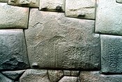
This is the most visited by tourists. In the street Hatun Rumiyoq ("Of the Mayor Rock") was the palace of Inca Roca, which currently belongs to the Archbishop's Palace.
In this street that runs from the Plaza de Armas to the Barrio de San Blas, it can see the Stone of Twelve Angles.
Convent and Church of la Merced
Its foundation dates from 1536. The first Mercy complex was destroyed by the earthquake of 1650 and the rebuilding of the church and convent was completed in 1675.
Its cloisters of Baroque Renaissance style highlights, and the choir stalls, colonial paintings and wood carvings.
You can also view a custodial of gold and precious stones of 22 kilos in weight and 130 cm in height.
Cathedral
In fact, the first cathedral of Cuzco is the Iglesia del Triunfo, built in 1539 on the basis of the Palace of Viracocha Inca. Today, this church is an auxiliary chapel of the Cathedral.
Between 1560 and 1664 it built the basilica cathedral of this city. To this end, the stone was used as the main material extracted from nearly quarries and partly reused blocks of red granite from the fortress known as Sacsayhuamán.
This great cathedral, of Renaissance plan interior presents late-Gothic, Baroque and plateresque interiors, and has one of the most outstanding examples of colonial goldsmith. Important are also its carved wooden altars.
Due this city was developed on canvas painting in the called "Cuzco School", precisely in the cathedral it can see major exhibitions of local artists of the time. It is the seat of the Roman Archdiocese of Cuzco.
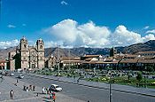
Plaza de Armas
"Square of the warrior" was called at the time of the Incas. This plaza has been the scene of several important events in the history of this city, as the proclamation by Francisco Pizarro in the conquest of Cuzco.
Similarly, the Plaza de Armas was the scenary of the death of Túpac Amaru II, considered the indigenous leader of the resistance.
The Spanish built in the plaza a stone arches, with Cuzco labor, which endures to this day. Here are the cathedral and the Church of La Compañía.

Population
Until the late 18th century Cuzco was the most populous city in the continent, even more than Lima. But because of the great revolution of Túpac Amaru in 1780, the white population migrated to Arequipa considered as the most secure and safe from a possible new uprising. So to the 20th century the population was largely mestizo and indigenous, but now the white population has grown significantly in the city as high as 30%, as it is experiencing a demographic explosion process led by the tourism boom.
The city has a population of 390,000 people by 2008 according to INEI.

|
| |||||||||||||||||||||||||||||||||||||||||||||||||||||||||||||||||||
Population of the city The city of Cuzco is composed of five districts:
| Municipality de La Ciudad |
Extension km² |
Population censo 2007(hab) |
Housing (2007) |
Density (hab/km²) |
Altitude msnm |
Distance (km) |
|---|---|---|---|---|---|---|
| Cuzco | 116,22 km² | 108.798* | 28.476 | 936,1 | 3.399 msnm | 0 km |
| San Jerónimo | 103,34 km² | 28.856* | 8.942 | 279,2 | 3.244 msnm | |
| San Sebastian | 89,44 km² | 85.472* | 18.109 | 955,6 | 3.244 msnm | |
| Santiago] | 69,72 km² | 66.277* | 21.168 | 950,6 | 3.400 msnm | |
| Wanchaq | 6,38 km² | 54.524* | 14.690 | 8.546,1 | 3.366 msnm | |
| Total | 385,1 km² | 358.052* | 91.385 | 929,76 | — | — |
| *Census data conducted by INEI[19] | ||||||
Food

As headquarters to the Inca Empire, Cusco was an important agricultural region. It was a natural reserve for thousands of native Peruvian species, including around 2,000 varieties of potato cultivated by the people.[20] Recently many fusion and neo-Andean restaurants have developed in Cusco, in which the cuisine is prepared with modern techniques and incorporates a blend of traditional Andean and international ingredients.[21] Also, recently opened a cacao and chocolate museum in the center of the city. The purpose of this place is to teach people about Peruvian cacao and also the whole process to make artisanal chocolate. The place is called ChocoMuseo.
Industry
International relations
Twin towns—Sister cities
|
Partnerships
Gallery
-

The Church of La Compañia on the Plaza de Armas -
12-sided stone -
 Chapel of the Holy Family / Capilla de la Sagrada Familia
 -
 Plaza de Armas


In modern culture
- In the children's movie The Emperor's New Groove and its spin-off animated television series The Emperor's New School, the main protagonist is "Kuzco", the young, often immature fictional emperor of the Incas.
- "Cuzco" was the name of a song on E.S. Posthumus' 2001 album Unearthed. Each song on the album was named after an ancient city.
- The Anthony Horowitz novel Evil Star takes places partly in Cusco.
See also
- Iperu, tourist information and assistance
- Tourism in Peru
- Inca road system
- Coricancha
- List of archaeoastronomical sites sorted by country
- PeruRail
- Pambokancha, Inca religious site
References
- Notes
- ^ "Constitución del Perъ de 1993". Pdba.georgetown.edu. Retrieved 22 July 2009.
- ^ Cerrón-Palomino, Rodolfo (2007). "Cuzco: La piedra donde se posó la lechuza. Historia de un nombre". Andina. 44. Lima: 143–174. ISBN 0259-9600.
{{cite journal}}: Check|isbn=value: length (help) - ^ Carrión Ordóñez, Enrique (1993). "Cuzco, con Z". Histórica. XVII. Lima: 267–270.
- ^ http://www.peru.info/e_ftociudadeseng.asp?ids=1290&ic=2&pdr=651&jrq=3.7
- ^ [1][dead link]
- ^ "City of Cusco - UNESCO World Heritage Centre". Whc.unesco.org. 21 August 2007. Retrieved 22 July 2009.
- ^ "Cusco Travel Information and Travel Guide - Peru". Lonely Planet. Retrieved 22 July 2009.
- ^ of words in English
- ^ Kelly Hearn, "Ancient Temple Discovered Among Inca Ruins", National Geographic News, 31 March 2008, accessed 12 January 2010
- ^ "NEWS - Comcast.net". Comcast.net<!. Retrieved 22 July 2009.
- ^ "The history of Cusco". cusco.net<!. Retrieved 25 July 2009.
- ^ http://www.sacred-destinations.com/peru/cusco-koricancha.htm
- ^ http://bssa.geoscienceworld.org/cgi/content/abstract/44/2A/97
- ^ Reuters via ABC News Australia "Opera House snubbed as new Wonders unveiled" 7 July 2007
- ^ Andes map
- ^ Liley, J. Ben and McKenzie, Richard L. (April 2006) "Where on Earth has the highest UV?" UV Radiation and its Effects: an update NIWA Science, Hamilton, NZ;
- ^ "World Weather Information Service - Cuzco". UN. Retrieved 3 May 2010.
- ^ "Average Conditions Cusco, Peru". BBC Weather. Retrieved March 2010.
{{cite web}}: Check date values in:|accessdate=(help) - ^ Censo 2005 INEI
- ^ "Cusco, Peru Bans GM Products To Protect Diversity Of Native Potatoes". Solutions-site.org. Retrieved 22 July 2009.
- ^ Guide to Peruvian Food, Cusco Reference
- ^ "Ciudades Hermanas (Sister Cities)" (in Spanish). Municipalidad del Cusco. Retrieved 23 September 2009.
- ^ "::Bethlehem Municipality::". www.bethlehem-city.org. Retrieved 10 October 2009.
- ^ "Kraków otwarty na świat". www.krakow.pl. Retrieved 19 July 2009.
External links
- Bibliography about Cuzco Template:Es
- Government Site Template:Es
- Government Cultural Site Template:Es
- PromPerú: Government Tourism Site on Cusco
- General facts and travel information about Cusco
- General information and basic facts
| Cultural |
| |
|---|---|---|
| Natural | ||
| Mixed |
| |