Soria: Difference between revisions
m →Sport |
No edit summary |
||
| Line 38: | Line 38: | ||
|footnotes = |
|footnotes = |
||
}} |
}} |
||
| ⚫ | |||
| ⚫ | |||
'''Soria''' is a city in north-central [[Spain]], the capital of the [[province of Soria]] in the [[autonomous communities of Spain|autonomous community]] of [[Castile and León]]. The [[municipality]] had a population of c. 39,500 inhabitants, nearly 40% of the population of the province. Situated on the [[Rio Duero]] in the east of the autonomous community, the city is noted for its walls and a number of architecturally distinctive churches. |
'''Soria''' is a city in north-central [[Spain]], the capital of the [[province of Soria]] in the [[autonomous communities of Spain|autonomous community]] of [[Castile and León]]. The [[municipality]] had a population of c. 39,500 inhabitants, nearly 40% of the population of the province. Situated on the [[Rio Duero]] in the east of the autonomous community, the city is noted for its walls and a number of architecturally distinctive churches. |
||
==History== |
==History== |
||
[[Image:Ermita El Mirón2.JPG|thumb|left|210px|Madonna del Mirón Hermitage, started to built in the [[VI century|VI century A.C.]] by the [[suebi]]s]] |
|||
The area of Soria was inhabited by the [[Iberians]], who merged with the [[Celts]] to form the [[Celtiberians]] around the 4th century BC. The name's origins are disputed: according to some scholars, it would derive from a Greek Achaian hero (''Orias''); a more considered theory has it stemming from ''Daurias'', ancient name of the Duero river. |
The area of Soria was inhabited by the [[Iberians]], who merged with the [[Celts]] to form the [[Celtiberians]] around the 4th century BC. The name's origins are disputed: according to some scholars, it would derive from a Greek Achaian hero (''Orias''); a more considered theory has it stemming from ''Daurias'', ancient name of the Duero river. |
||
| ⚫ | |||
During the Roman invasion of Spain, Soria was besieged and its population committed a collective suicide in order to escape slavery. After the fall of the [[Western Roman Empire]], the rebuilt city was occupied by the [[Suebi]]. Later, after the [[Arab conquests|Arab]] conquest of Spain, it grew in importance due to its vicinity with the border with the Christian lands, which in the 8th century had stabilized across the Duero. |
During the Roman invasion of Spain, Soria was besieged and its population committed a collective suicide in order to escape slavery. After the fall of the [[Western Roman Empire]], the rebuilt city was occupied by the [[Suebi]]. Later, after the [[Arab conquests|Arab]] conquest of Spain, it grew in importance due to its vicinity with the border with the Christian lands, which in the 8th century had stabilized across the Duero. |
||
| Line 57: | Line 58: | ||
==Main sights== |
==Main sights== |
||
| ⚫ | |||
*The Renaissance ''Ayuntamiento'' (Town Hall, 16th century), in the ''Plaza Mayor'' (main square) |
*The Renaissance ''Ayuntamiento'' (Town Hall, 16th century), in the ''Plaza Mayor'' (main square) |
||
*''Palacio de la Audiencia'' (theatre), from 1739 |
*''Palacio de la Audiencia'' (theatre), from 1739 |
||
| Line 65: | Line 67: | ||
*''San Polo'', a former monastery of the [[Knights Templar]]. The churches of ''San Nicolas'' and San Gines'' are from the same age. |
*''San Polo'', a former monastery of the [[Knights Templar]]. The churches of ''San Nicolas'' and San Gines'' are from the same age. |
||
*the Romanesque convent church of [[Santo Domingo]] (12th century) |
*the Romanesque convent church of [[Santo Domingo]] (12th century) |
||
| ⚫ | |||
| ⚫ | |||
*[[San Juan de Duero]] withe the 12th century ruined cloisters, on the other side of the river from the old town. |
*[[San Juan de Duero]] withe the 12th century ruined cloisters, on the other side of the river from the old town. |
||
*sanctuaries of ''Ermita de San Saturio'' (18th century) and ''Ermita de la Soledad'' (17th century) |
*sanctuaries of ''Ermita de San Saturio'' (18th century) and ''Ermita de la Soledad'' (17th century) |
||
| Line 73: | Line 77: | ||
==Culture== |
==Culture== |
||
[[Image:Sanjuansoria.jpg|thumb| |
[[Image:Sanjuansoria.jpg|thumb|245px|San Juan´s feast day in Soria.]] |
||
The 20th century Spanish poet [[Antonio Machado]] spent five years in Soria teaching [[French language|French]] in a [[secondary school]] in the early part of the century, before spending 12 years in the neighbouring town of [[Segovia]]. These years were to prove essential to his further literary development. He married and lost his wife there and discovered much about the nature of the [[Castilian people]] – a subject about which the [[Generation of '98]] authors were very interested. |
The 20th century Spanish poet [[Antonio Machado]] spent five years in Soria teaching [[French language|French]] in a [[secondary school]] in the early part of the century, before spending 12 years in the neighbouring town of [[Segovia]]. These years were to prove essential to his further literary development. He married and lost his wife there and discovered much about the nature of the [[Castilian people]] – a subject about which the [[Generation of '98]] authors were very interested. |
||
| Line 87: | Line 91: | ||
*{{flagicon|FRA}} [[Collioure]], [[France]] |
*{{flagicon|FRA}} [[Collioure]], [[France]] |
||
| ⚫ | |||
==See also== |
==See also== |
||
*[[List of Spanish cities]] |
*[[List of Spanish cities]] |
||
| Line 93: | Line 96: | ||
*[[Numantia]] |
*[[Numantia]] |
||
==Gallery== |
|||
<gallery> |
|||
Image:StoDomingo-Conjunto.jpg|Santo Domingo Church (XII century). |
|||
Image:San_Pedrosoria.jpg|Concatedral de San Pedro de Soria, founded in 1152. |
|||
Image:SanJuanRabanera-Abside.jpg|Apse of San Juan de Rabanera Church, built in the XII century. |
|||
Image:San Juan de Duero.JPG|Cloister of Arcos de San Juan de Duero, (XII century). |
|||
</gallery> |
|||
| ⚫ | |||
==References== |
==References== |
||
{{reflist}} |
{{reflist}} |
||
Revision as of 05:06, 17 September 2010
Soria | |
|---|---|
 Main square of Soria | |
 Seal | |
 | |
| Country | |
| Autonomous community | |
| Province | Soria |
| Municipality | Soria |
| Government | |
| • Mayor | Carlos Martínez Mínguez |
| Area | |
| • Total | 272 km2 (105 sq mi) |
| Elevation | 1,063 m (3,488 ft) |
| Population (2009) | |
| • Total | 39,528 |
| • Density | 150/km2 (380/sq mi) |
| Time zone | UTC+1 (CET) |
| • Summer (DST) | UTC+2 (CEST) |
| Website | www.ayto-soria.es |
Soria is a city in north-central Spain, the capital of the province of Soria in the autonomous community of Castile and León. The municipality had a population of c. 39,500 inhabitants, nearly 40% of the population of the province. Situated on the Rio Duero in the east of the autonomous community, the city is noted for its walls and a number of architecturally distinctive churches.
History

The area of Soria was inhabited by the Iberians, who merged with the Celts to form the Celtiberians around the 4th century BC. The name's origins are disputed: according to some scholars, it would derive from a Greek Achaian hero (Orias); a more considered theory has it stemming from Daurias, ancient name of the Duero river.
During the Roman invasion of Spain, Soria was besieged and its population committed a collective suicide in order to escape slavery. After the fall of the Western Roman Empire, the rebuilt city was occupied by the Suebi. Later, after the Arab conquest of Spain, it grew in importance due to its vicinity with the border with the Christian lands, which in the 8th century had stabilized across the Duero.
In 869 Soria was the centre of the rebellion of Suleyman ibn-Abus against the caliph of Córdoba, who sent his son Hakan to quench it. In the early 12th century the city was conquered by Alfonso I the Battler, being absorbed into the Kingdom of León in 1134. Due to its strategic placement at the borders of the Kingdoms of Castile, Aragon, Navarre and León, Soria in the Middle Ages was at the centre of several conflicts between them. Alfonso VIII of Castile, in reward for its support, gave the city several privileges which it maintained until modern times. In 1195 the town was stormed by Sancho VII of Navarre, but later recovered and continued to develop its splendour and trades, mostly held by a community of Jews.

Soria lost most of its importance after the unification of Aragon and Castile in 1479, and above all after the decree of exile issued against the Jews in 1492. In the War of Spanish Succession (early 18th century), Soria sided for Philip V. In 1808 it was captured and set on fire by the French troops.
The economical and social crisis of Spain in the early 20th century, and the Spanish Civil War with Francisco Franco's dictatorship which followed, had negative effects on Soria and its neighborhood, which became depopulated due to strong emigration.
The policy of the current authorities aims to strengthen the local economy pivoting on Soria's tourism potential, and has also launched a program of reconstruction for the neighbouring villages.
Main sights

- The Renaissance Ayuntamiento (Town Hall, 16th century), in the Plaza Mayor (main square)
- Palacio de la Audiencia (theatre), from 1739
- Nuestra Señora de la Mayor (16th century), with a Romanesque portal
- Iglesia del Espino (16th century)
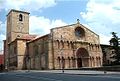
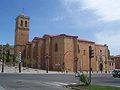
- Plateresque Concatedral de San Pedro, erected in the 12th-13th centuries, rebuilt in the 16th century, and its cloister.
- San Juan de Rabanera, Romanesque church from the 12th century
- San Polo, a former monastery of the Knights Templar. The churches of San Nicolas and San Gines are from the same age.
- the Romanesque convent church of Santo Domingo (12th century)


- San Juan de Duero withe the 12th century ruined cloisters, on the other side of the river from the old town.
- sanctuaries of Ermita de San Saturio (18th century) and Ermita de la Soledad (17th century)
- Palacio de los condes de Gomara (Judiciary Palace, 1592)
- remains of the medieval castle, commanding the town from the eponymous hill, and of the walls
A few kilometres north of the town are the ruins of Numantia, a Celtiberian town whose inhabitants destroyed it rather than let it fall to Scipio. In Soria is the Museo Numantino, devoted to the archaeological remains of this site.
Culture

The 20th century Spanish poet Antonio Machado spent five years in Soria teaching French in a secondary school in the early part of the century, before spending 12 years in the neighbouring town of Segovia. These years were to prove essential to his further literary development. He married and lost his wife there and discovered much about the nature of the Castilian people – a subject about which the Generation of '98 authors were very interested.
Sport
The city's professional football club is called CD Numancia.
Two of Spain's foremost runners of the late 20th century lived and trained in Soria: Fermín Cacho, a gold medallist at the 1992 Barcelona Olympics, and Abel Antón, a two-time World Champion in the marathon. The area in which they trained, Monte Valonsadero, is now host to the annual Cross Internacional de Soria meeting – one of Spain's most prestigious cross country running competitions.[1][2]
The European Youth Orienteering Championships were held in Soria in July 2010. [1]
Twin towns
See also
Gallery
-
 Santo Domingo Church (XII century).
 -
 Concatedral de San Pedro de Soria, founded in 1152.
 -
 Apse of San Juan de Rabanera Church, built in the XII century.
 -
 Cloister of Arcos de San Juan de Duero, (XII century).


References
- ^ Valiente, Emerterio (2007-11-23). Spotlight on Ebuya and Melkamu - Soria Cross Country preview. IAAF. Retrieved on 2009-11-29.
- ^ Historia del Cross Internacional de Soria Template:Es icon. ANOC. Retrieved on 2009-11-29.
41°46′N 2°28′W / 41.767°N 2.467°W
