Condado de Treviño: Difference between revisions
Undid revision 313860756 by French Tourist (talk) See talk page |
new pictures added |
||
| Line 41: | Line 41: | ||
In the 13th century, the [[king of Castile]] and the [[king of Navarre]] exchanged it for some towns in current [[Rioja (Spain)|Rioja]]. A population growth ensued, this explains why it is a Burgos [[exclave]] surrounded by [[Álava]] land. The Alavese capital [[Vitoria-Gasteiz]] is much nearer than [[Burgos]]. [[Basque nationalism|Basque irredentism]] claims the county (''Trebiñuko Konderria'' in Basque) as part of Álava, but the Castile-Leon government opposes the transfer. |
In the 13th century, the [[king of Castile]] and the [[king of Navarre]] exchanged it for some towns in current [[Rioja (Spain)|Rioja]]. A population growth ensued, this explains why it is a Burgos [[exclave]] surrounded by [[Álava]] land. The Alavese capital [[Vitoria-Gasteiz]] is much nearer than [[Burgos]]. [[Basque nationalism|Basque irredentism]] claims the county (''Trebiñuko Konderria'' in Basque) as part of Álava, but the Castile-Leon government opposes the transfer. |
||
| ⚫ | |||
| ⚫ | |||
[[Image:N1 Trebinu.jpg|thumb|Condado de Treviño is crossed by the [[Nacional N-1]] road.]] |
|||
==See also== |
==See also== |
||
*[[Villaverde de Trucíos]], another exclave surrounded by Basque land. |
*[[Villaverde de Trucíos]], another exclave surrounded by Basque land. |
||
| ⚫ | |||
| ⚫ | |||
==Gallery of towns of Condado de Treviño== |
|||
<gallery> |
|||
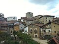
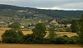
File:Treviño.jpg|Treviño village. |
|||
File:Armentia trebiñu.jpg|Armentia town. |
|||
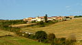
File:Arrieta mendia eta herria.jpg|Arrieta town. |
|||
File:Arrietatrebiñu.jpg|A street of Arrieta. |
|||
File:Bustu.jpg|Busto de Treviño town. |
|||
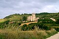
File:Obekuri 2007 9 27.JPG|Obécuri town. |
|||
File:Doroñu.jpg|Doroño town. |
|||
File:Franku trebiñu.jpg|Franco town. |
|||
File:Golernio.jpg|Golernio town. |
|||
File:Imiruri.jpg|Imiruri town. |
|||
File:Ozana.jpg|Asunción de Nuestra Señora Church, in Ozana town. |
|||
File:Kutxuko eliza eta plaza.jpg|Invención de la Santa Cruz Church in Cucho town. |
|||
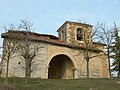
File:San vicentejo.jpg|La Concepción Hermitage (XII century), in San Vicentejo town. |
|||
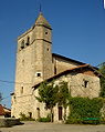
File:Iglesia de Saraso.jpg|San Andrés Church (XII century), in Saraso town. |
|||
File: Añastroko eliza.jpg|San Andrés Church (XVI century) in Añastro town. |
|||
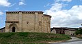
File:Ochate.JPG|The abadoned Ochate town, with the tower of the ancient San Miguel Church. |
|||
</gallery> |
|||
{{Municipalities in Burgos}} |
{{Municipalities in Burgos}} |
||
Revision as of 00:08, 29 September 2009
Condado de Treviño, Spain | |
|---|---|
| Nickname: Treviño | |
 | |
| Country | Spain |
| Autonomous community | Castile and León |
| Province | Burgos |
| Municipality | Condado de Treviño |
| Area | |
| • Total | 260 km2 (100 sq mi) |
| Population (2004) | |
| • Total | 1,282 |
| • Density | 4.9/km2 (13/sq mi) |
| Time zone | UTC+1 (CET) |
| • Summer (DST) | UTC+2 (CEST) |
This article needs additional citations for verification. (October 2007) |
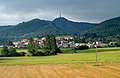
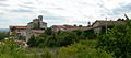
Condado de Treviño ("County of Treviño") is a part of the province of Burgos, Castile and León, Spain, and is completely surrounded by the Basque Province of Álava. It is formed around the town of Treviño (officially named Condado de Treviño and La Puebla de Arganzón). According to the 2004 census (INE), the municipality has a population of 1,282 inhabitants.
In the 13th century, the king of Castile and the king of Navarre exchanged it for some towns in current Rioja. A population growth ensued, this explains why it is a Burgos exclave surrounded by Álava land. The Alavese capital Vitoria-Gasteiz is much nearer than Burgos. Basque irredentism claims the county (Trebiñuko Konderria in Basque) as part of Álava, but the Castile-Leon government opposes the transfer.
See also
- Villaverde de Trucíos, another exclave surrounded by Basque land.


Gallery of towns of Condado de Treviño
-
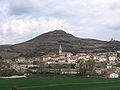 Treviño village.
 -
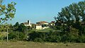 Armentia town.
 -
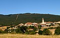 Arrieta town.
 -
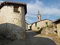 A street of Arrieta.
 -
 Busto de Treviño town.
 -
 Obécuri town.
 -
 Doroño town.
 -
 Franco town.
 -
 Golernio town.
 -
 Imiruri town.
 -
 Asunción de Nuestra Señora Church, in Ozana town.
 -
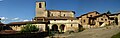 Invención de la Santa Cruz Church in Cucho town.
 -
 La Concepción Hermitage (XII century), in San Vicentejo town.
 -
 San Andrés Church (XII century), in Saraso town.
 -
 San Andrés Church (XVI century) in Añastro town.
 -
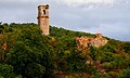 The abadoned Ochate town, with the tower of the ancient San Miguel Church.


42°44′06″N 2°44′49″W / 42.735°N 2.747°W
This article about a location in the province of Burgos, Spain is a stub. You can help Wikipedia by expanding it. |