Churún River
(Redirected from Churun River)
| Churún River | |
|---|---|
 Churún River, Cañón del Diablo and Angel Falls. | |
| Location | |
| Country | Venezuela |
| State | Bolívar |
| Physical characteristics | |
| Source | Auyán-tepui |
| • coordinates | 5°52′44″N 62°35′12″W / 5.8789°N 62.5867°W |
| • elevation | 1,590 m (5,220 ft)[1] |
| Mouth | Carrao River |
• coordinates | 6°04′50″N 62°37′10″W / 6.08056°N 62.61944°W |
• elevation | 450 m (1,480 ft) |
| Length | 54.34 km (33.77 mi)[2] |
| Basin size | 580 km2 (220 sq mi) |
| Discharge | |
| • average | 20,000 cu ft/s (570 m3/s) |
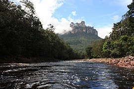
The Churún River (Spanish: Río Churún) is a river in Venezuela, part of the Orinoco River basin. It is located in Canaima National Park and a tributary comes from the Angel Falls, which are the world's tallest single-drop waterfall.
Gallery
[edit]-
 Rio Churun is the gateway to Angel Falls.
.jpg?lang=en)
References
[edit]